Property Record
430 Fairhill Rd, Hatfield, PA 19440
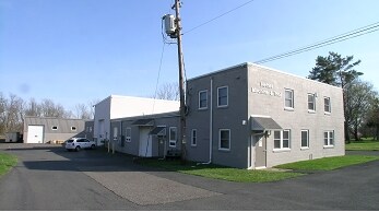

Property Detail
430 Fairhill Rd
15-024-056
6.029 AC 584 E T332 378 LR09081
Industrialgeneral
Bucks
RR
Pennsylvania
B and X Area of moderate flood hazard, usually the area between the limits of the 100-year and 500-year floods.
6.03 AC
2024
Bucks
2025
Philadelphia
102104
Philadelphia-Camden-Wilmington, PA-NJ-DE-MD
15,082 SF
NEARBY LISTINGS FOR SALE OR LEASE
DEMOGRAPHICS near 430 Fairhill Rd
1 mile
3 mile
5 mile
2025 Total Population
1,429
50,520
118,947
2030 Population
1,432
52,152
121,833
Pop Growth 2025-2030
+ 0.21%
+ 3.23%
+ 2.43%
Average Age
45
42
42
2025 Total Households
524
19,064
45,163
HH Growth 2025-2030
+ 0.38%
+ 2.92%
+ 2.32%
Median Household Inc
$123,499
$100,627
$105,184
Avg Household Size
2.70
2.60
2.60
2025 Avg HH Vehicles
2.00
2.00
2.00
Median Home Value
$470,833
$407,396
$426,312
Median Year Built
1984
1980
1978
Nearby Places
Map Layers
Map Styles
 Street
 Aerial
Layers
 Traffic
 Biking
Places
Listings with unknown addresses are not visible on the map
- Restaurants
- Banks
- Shops
- Fitness
- Groceries
PUBLIC TRANSPORTATION
COMMUTER RAIL
Link Belt (R5 - Southeastern Pennsylvania Transportation Authority Regional Rail (SEPTA Regional Rail))
Drive
Walk
Distance
Link Belt (R5 - Southeastern Pennsylvania Transportation Authority Regional Rail (SEPTA Regional Rail))
9 min
4.7 mi
Colmar (R5 - Southeastern Pennsylvania Transportation Authority Regional Rail (SEPTA Regional Rail))
Drive
Walk
Distance
Colmar (R5 - Southeastern Pennsylvania Transportation Authority Regional Rail (SEPTA Regional Rail))
9 min
4.7 mi
AIRPORT
Lehigh Valley International
Drive
Walk
Distance
Lehigh Valley International
49 min
28.5 mi
Trenton Mercer
Drive
Walk
Distance
Trenton Mercer
59 min
34.6 mi
Philadelphia International
Drive
Walk
Distance
Philadelphia International
63 min
43.7 mi
SALE & LEASE HISTORY
LISTING DATE
SALE/LEASE

Sep 24, 2016
For Sale
Nearby Properties
Address
Land Use
TOTAL SIZE
Lot Size
Zoning
Address
Land Use
TOTAL SIZE
Lot Size
Zoning
977,439 SF
70.93 AC
GA
Address
Land Use
TOTAL SIZE
Lot Size
Zoning
412,306 SF
40.91 AC
I
Address
Land Use
TOTAL SIZE
Lot Size
Zoning
253,915 SF
17.78 AC
GA
Address
Land Use
TOTAL SIZE
Lot Size
Zoning
152,085 SF
38.16 AC
INST
Address
Land Use
TOTAL SIZE
Lot Size
Zoning
444,718 SF
46.51 AC
LI
Address
Land Use
TOTAL SIZE
Lot Size
Zoning
324,796 SF
42.20 AC
LI
Address
Land Use
TOTAL SIZE
Lot Size
Zoning
216,372 SF
18.46 AC
INST
Address
Land Use
TOTAL SIZE
Lot Size
Zoning
502,169 SF
83.16 AC
LI
Address
Land Use
TOTAL SIZE
Lot Size
Zoning
35.37 AC
LI
Address
Land Use
TOTAL SIZE
Lot Size
Zoning
213,542 SF
26.53 AC
LI
Address
Land Use
TOTAL SIZE
Lot Size
Zoning
184,471 SF
0.80 AC
INST
Address
Land Use
TOTAL SIZE
Lot Size
Zoning
65,178 SF
16.86 AC
B
Address
Land Use
TOTAL SIZE
Lot Size
Zoning
94,598 SF
27.72 AC
INST
Address
Land Use
TOTAL SIZE
Lot Size
Zoning
230,016 SF
11.27 AC
LI
Address
Land Use
TOTAL SIZE
Lot Size
Zoning
182,010 SF
12.25 AC
LI
Address
Land Use
TOTAL SIZE
Lot Size
Zoning
40,754 SF
6.23 AC
LI
Address
Land Use
TOTAL SIZE
Lot Size
Zoning
60,470 SF
14.60 AC
ER
Address
Land Use
TOTAL SIZE
Lot Size
Zoning
85,508 SF
25.83 AC
Address
Land Use
TOTAL SIZE
Lot Size
Zoning
237,667 SF
37.86 AC
LI
Address
Land Use
TOTAL SIZE
Lot Size
Zoning
121,762 SF
16.66 AC
LI
Address
Land Use
TOTAL SIZE
Lot Size
Zoning
63,183 SF
23.05 AC
INST
Address
Land Use
TOTAL SIZE
Lot Size
Zoning
90,211 SF
1.38 AC
C
Address
Land Use
TOTAL SIZE
Lot Size
Zoning
71,431 SF
2.65 AC
R2
Address
Land Use
TOTAL SIZE
Lot Size
Zoning
128,619 SF
7.61 AC
LI
Address
Land Use
TOTAL SIZE
Lot Size
Zoning
134,704 SF
34.23 AC
PC1
Address
Land Use
TOTAL SIZE
Lot Size
Zoning
146,539 SF
12.68 AC
LI
Address
Land Use
TOTAL SIZE
Lot Size
Zoning
53,795 SF
3.64 AC
INST
Address
Land Use
TOTAL SIZE
Lot Size
Zoning
52,092 SF
5.91 AC
R2
Address
Land Use
TOTAL SIZE
Lot Size
Zoning
98,397 SF
8.23 AC
LI
Address
Land Use
TOTAL SIZE
Lot Size
Zoning
42,494 SF
11.19 AC
C
The World's #1 Commercial Real Estate Marketplace
Connect with us
© 2026 CoStar Group
The information above has been obtained from sources believed reliable. While we do not doubt its accuracy we have not verified it and make no guarantee, warranty or representation about it. It is your responsibility to independently confirm its accuracy and completeness. Any projections, opinions, assumptions, or estimates used are for example only and do not represent the current or future performance of the property. The value of this transaction to you depends on tax and other factors which should be evaluated by your tax, financial, and legal advisors. You and your advisors should conduct a careful, independent investigation of the property to determine to your satisfaction the suitability of the property for your needs.