Property Record
430 Ledge Rd, Dayville, CT 06241
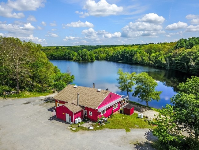

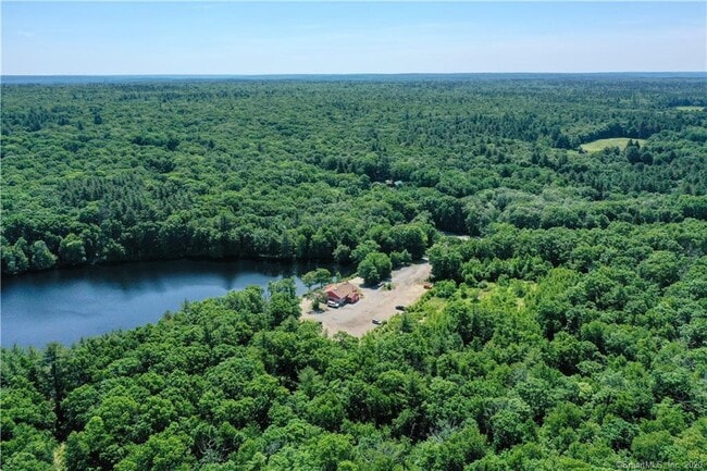
Property Detail
430 Ledge Rd
Restaurantbuilding
WINDHAM
RD
Connecticut
A Areas with a 1% annual chance of flooding and a 26% chance of flooding over the life of a 30-year mortgage.
78.84 AC
2025
Windham County
2025
Hartford
904102
Willimantic, CT
1,904 SF
KILL-000168-000000-000001
NEARBY LISTINGS FOR SALE OR LEASE
-
-
View all Dayville listings for sale on LoopNet.com
DEMOGRAPHICS near 430 Ledge Rd
1 mile
3 mile
5 mile
2025 Total Population
219
4,173
16,144
2030 Population
223
4,249
16,551
Pop Growth 2025-2030
+ 1.83%
+ 1.82%
+ 2.52%
Average Age
45
45
44
2025 Total Households
87
1,676
6,625
HH Growth 2025-2030
+ 1.15%
+ 1.91%
+ 2.64%
Median Household Inc
$102,500
$105,327
$88,365
Avg Household Size
2.50
2.50
2.40
2025 Avg HH Vehicles
2.00
2.00
2.00
Median Home Value
$370,454
$336,961
$321,602
Median Year Built
1978
1978
1969
Nearby Places
Map Layers
Map Styles
 Street
 Aerial
Transit
 Traffic
 Biking
Places
Listings with unknown addresses are not visible on the map
- Restaurants
- Banks
- Shops
- Fitness
- Groceries
PUBLIC TRANSPORTATION
AIRPORT
Rhode Island Tf Green International
Drive
Walk
Distance
Rhode Island Tf Green International
43 min
28.3 mi
Freight Ports
Port of Davisville, RI
Drive
Walk
Distance
Port of Davisville, RI
55 min
37.5 mi
SALE & LEASE HISTORY
LISTING DATE
SALE/LEASE

Sep 01, 2017
For Sale
Nov 16, 2017
For Sale
Jun 26, 2020
For Sale
Apr 08, 2019
For Sale
Nearby Properties
Address
Land Use
TOTAL SIZE
Lot Size
Zoning
Address
Land Use
TOTAL SIZE
Lot Size
Zoning
6,250 SF
225 AC
RD
Address
Land Use
TOTAL SIZE
Lot Size
Zoning
5,476 SF
2.46 AC
VC
Address
Land Use
TOTAL SIZE
Lot Size
Zoning
Address
Land Use
TOTAL SIZE
Lot Size
Zoning
4,528 SF
7.10 AC
1
Address
Land Use
TOTAL SIZE
Lot Size
Zoning
15,840 SF
14.90 AC
RD
Address
Land Use
TOTAL SIZE
Lot Size
Zoning
647 AC
RD
Address
Land Use
TOTAL SIZE
Lot Size
Zoning
9,828 SF
10.16 AC
1
Address
Land Use
TOTAL SIZE
Lot Size
Zoning
Address
Land Use
TOTAL SIZE
Lot Size
Zoning
2,000 SF
2.17 AC
30
Address
Land Use
TOTAL SIZE
Lot Size
Zoning
1,161 SF
6.10 AC
1
Address
Land Use
TOTAL SIZE
Lot Size
Zoning
5,184 SF
33 AC
RD
Address
Land Use
TOTAL SIZE
Lot Size
Zoning
1,696 SF
5 AC
1
Address
Land Use
TOTAL SIZE
Lot Size
Zoning
1,638 SF
2.75 AC
30
Address
Land Use
TOTAL SIZE
Lot Size
Zoning
1,728 SF
13.01 AC
1
Address
Land Use
TOTAL SIZE
Lot Size
Zoning
4,208 SF
0.50 AC
30
Address
Land Use
TOTAL SIZE
Lot Size
Zoning
8,628 SF
4.40 AC
RD
Address
Land Use
TOTAL SIZE
Lot Size
Zoning
768 SF
5.30 AC
1
Address
Land Use
TOTAL SIZE
Lot Size
Zoning
1,184 SF
2 AC
1
Address
Land Use
TOTAL SIZE
Lot Size
Zoning
1,793 SF
1 AC
1
Address
Land Use
TOTAL SIZE
Lot Size
Zoning
1,386 SF
0.62 AC
1
Address
Land Use
TOTAL SIZE
Lot Size
Zoning
3,012 SF
4.59 AC
30
Address
Land Use
TOTAL SIZE
Lot Size
Zoning
552 SF
2.30 AC
1
Address
Land Use
TOTAL SIZE
Lot Size
Zoning
6,863 SF
23.09 AC
30
Address
Land Use
TOTAL SIZE
Lot Size
Zoning
2,880 SF
53 AC
MMUDD
Address
Land Use
TOTAL SIZE
Lot Size
Zoning
30.98 AC
1
Address
Land Use
TOTAL SIZE
Lot Size
Zoning
2,964 SF
11 AC
1
Address
Land Use
TOTAL SIZE
Lot Size
Zoning
1,486 SF
42.78 AC
RD
Address
Land Use
TOTAL SIZE
Lot Size
Zoning
1,140 SF
4.33 AC
1
Address
Land Use
TOTAL SIZE
Lot Size
Zoning
0.60 AC
RD
Address
Land Use
TOTAL SIZE
Lot Size
Zoning
0.74 AC
RD
The World's #1 Commercial Real Estate Marketplace
Connect with us
© 2026 CoStar Group
The information above has been obtained from sources believed reliable. While we do not doubt its accuracy we have not verified it and make no guarantee, warranty or representation about it. It is your responsibility to independently confirm its accuracy and completeness. Any projections, opinions, assumptions, or estimates used are for example only and do not represent the current or future performance of the property. The value of this transaction to you depends on tax and other factors which should be evaluated by your tax, financial, and legal advisors. You and your advisors should conduct a careful, independent investigation of the property to determine to your satisfaction the suitability of the property for your needs.