Property Record
430 N Main St, Florence, MA 01062
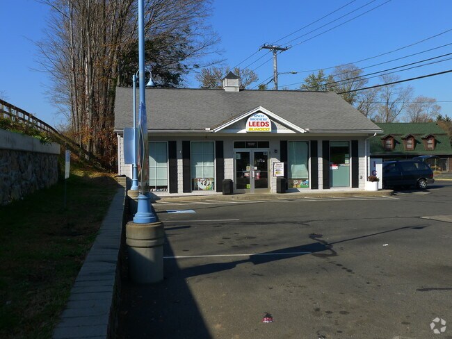

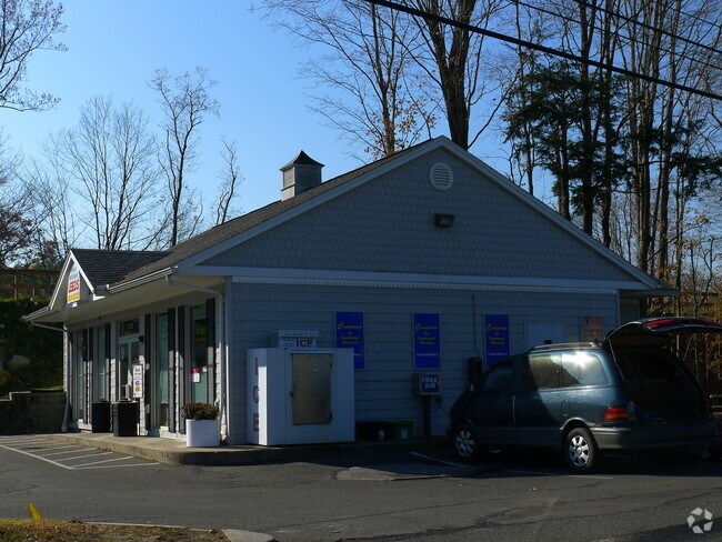
Property Detail
430 N Main St
NHAM-000011C-000054-000001
HAMPSHIRE
Servicestation
Massachusetts
HB
1
2025
0.28 AC
2025
Hampshire County
822200
Hartford
1,356 SF
Amherst Town-Northampton, MA
NEARBY LISTINGS FOR SALE OR LEASE
DEMOGRAPHICS near 430 N Main St
1 mile
3 mile
5 mile
2025 Total Population
2,850
17,379
36,056
2030 Population
2,842
17,292
35,883
Pop Growth 2025-2030
(0.28%)
(0.50%)
(0.48%)
Average Age
51
45
43
2025 Total Households
1,131
7,460
15,585
HH Growth 2025-2030
(0.80%)
(0.62%)
(0.56%)
Median Household Inc
$87,500
$83,511
$78,825
Avg Household Size
2.10
2.10
2.10
2025 Avg HH Vehicles
2.00
2.00
2.00
Median Home Value
$402,206
$416,887
$438,688
Median Year Built
1969
1960
1956
Nearby Places
Map Layers
Map Styles
 Street
 Aerial
Layers
 Traffic
 Biking
Places
Listings with unknown addresses are not visible on the map
- Restaurants
- Banks
- Shops
- Fitness
- Groceries
PUBLIC TRANSPORTATION
COMMUTER RAIL
Northampton (Valley Flyer - Amtrak, Vermonter - Amtrak)
Drive
Walk
Distance
Northampton (Valley Flyer - Amtrak, Vermonter - Amtrak)
10 min
4.3 mi
AIRPORT
Bradley International
Drive
Walk
Distance
Bradley International
61 min
33.9 mi
Freight Ports
Albany, NY Port
Drive
Walk
Distance
Albany, NY Port
118 min
90.7 mi
Nearby Properties
Address
Land Use
TOTAL SIZE
Lot Size
Zoning
Address
Land Use
TOTAL SIZE
Lot Size
Zoning
18.04 AC
URB
Address
Land Use
TOTAL SIZE
Lot Size
Zoning
143,471 SF
22.12 AC
URA
Address
Land Use
TOTAL SIZE
Lot Size
Zoning
26.50 AC
URB
Address
Land Use
TOTAL SIZE
Lot Size
Zoning
12.23 AC
HB
Address
Land Use
TOTAL SIZE
Lot Size
Zoning
30.42 AC
URB
Address
Land Use
TOTAL SIZE
Lot Size
Zoning
10.37 AC
HB
Address
Land Use
TOTAL SIZE
Lot Size
Zoning
243,012 SF
24.96 AC
URB
Address
Land Use
TOTAL SIZE
Lot Size
Zoning
131.99 AC
HB
Address
Land Use
TOTAL SIZE
Lot Size
Zoning
42,070 SF
4.38 AC
URA
Address
Land Use
TOTAL SIZE
Lot Size
Zoning
5.06 AC
URC
Address
Land Use
TOTAL SIZE
Lot Size
Zoning
4.73 AC
URA
Address
Land Use
TOTAL SIZE
Lot Size
Zoning
63.16 AC
URB
Address
Land Use
TOTAL SIZE
Lot Size
Zoning
5.87 AC
SR
Address
Land Use
TOTAL SIZE
Lot Size
Zoning
10.07 AC
URB
Address
Land Use
TOTAL SIZE
Lot Size
Zoning
16.77 AC
SI
Address
Land Use
TOTAL SIZE
Lot Size
Zoning
56,893 SF
1.22 AC
URB
Address
Land Use
TOTAL SIZE
Lot Size
Zoning
49,757 SF
11.07 AC
SR
Address
Land Use
TOTAL SIZE
Lot Size
Zoning
36,263 SF
1.49 AC
GB
Address
Land Use
TOTAL SIZE
Lot Size
Zoning
768 SF
2.13 AC
URB
Address
Land Use
TOTAL SIZE
Lot Size
Zoning
938 AC
RR
Address
Land Use
TOTAL SIZE
Lot Size
Zoning
2.88 AC
URB
Address
Land Use
TOTAL SIZE
Lot Size
Zoning
40,072 SF
0.59 AC
GB
Address
Land Use
TOTAL SIZE
Lot Size
Zoning
103.56 AC
SR
Address
Land Use
TOTAL SIZE
Lot Size
Zoning
77,732 SF
10.51 AC
SR
Address
Land Use
TOTAL SIZE
Lot Size
Zoning
6.30 AC
URB
Address
Land Use
TOTAL SIZE
Lot Size
Zoning
36.70 AC
URA
Address
Land Use
TOTAL SIZE
Lot Size
Zoning
34.39 AC
RR
Address
Land Use
TOTAL SIZE
Lot Size
Zoning
18.24 AC
URA
Address
Land Use
TOTAL SIZE
Lot Size
Zoning
174.89 AC
RR
Address
Land Use
TOTAL SIZE
Lot Size
Zoning
22,936 SF
5.13 AC
B
The World's #1 Commercial Real Estate Marketplace
Connect with us
© 2026 CoStar Group
The information above has been obtained from sources believed reliable. While we do not doubt its accuracy we have not verified it and make no guarantee, warranty or representation about it. It is your responsibility to independently confirm its accuracy and completeness. Any projections, opinions, assumptions, or estimates used are for example only and do not represent the current or future performance of the property. The value of this transaction to you depends on tax and other factors which should be evaluated by your tax, financial, and legal advisors. You and your advisors should conduct a careful, independent investigation of the property to determine to your satisfaction the suitability of the property for your needs.