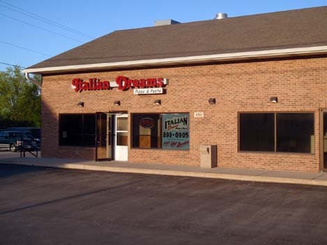
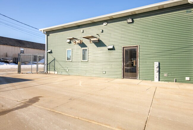
Property Record
430 N Main St, Sycamore, IL 60178
NEARBY LISTINGS FOR SALE OR LEASE
Property Detail
430 N Main St
Chicago-Naperville-Elgin, IL-IN-WI
Boyntons Addition
06-32-227-011
BOYNTONS ADDITION - N 130FT OF S 240FT OF W 120FT & E 5FT OF W 125FT OF N 80FT OF S 190FT
Commercialnec
DeKalb
X
Illinois
17037C0256E
b
2023
0.37 AC
2024
Western East/West Corr
000600
Chicago
4,000 SF
DEMOGRAPHICS near 430 N Main St
1 Mile
3 Mile
5 Mile
2024 Total Population
7,336
20,593
33,455
2029 Population
7,236
20,319
33,062
Pop Growth 2024-2029
(1.36%)
(1.33%)
(1.17%)
Average Age
39
40
40
2024 Total Households
3,050
8,205
13,191
HH Growth 2024-2029
(1.51%)
(1.46%)
(1.35%)
Median Household Inc
$71,296
$82,326
$81,353
Avg Household Size
2.40
2.50
2.50
2024 Avg HH Vehicles
2.00
2.00
2.00
Median Home Value
$214,446
$233,342
$214,761
Median Year Built
1975
1987
1983
Nearby Places
Map Layers
Map Styles
 Street
 Aerial
- Restaurants
- Banks
- Shops
- Fitness
- Groceries
PUBLIC TRANSPORTATION
AIRPORT
Chicago/Rockford International
DRIVE
WALK
Distance
Chicago/Rockford International
52 min
35.1 mi
Freight Ports
Port Milwaukee
DRIVE
WALK
Distance
Port Milwaukee
132 min
96.4 mi
SALE & LEASE HISTORY
LISTING DATE
SALE/LEASE

Sep 25, 2016
For Lease
Mar 02, 2021
For Lease
Nearby Properties
Address
Land Use
TOTAL SIZE
Lot Size
Zoning
Address
Land Use
TOTAL SIZE
Lot Size
Zoning
Address
Land Use
TOTAL SIZE
Lot Size
Zoning
204,828 SF
27.88 AC
Address
Land Use
TOTAL SIZE
Lot Size
Zoning
42,453 SF
13.08 AC
RC2
Address
Land Use
TOTAL SIZE
Lot Size
Zoning
13.48 AC
BC
Address
Land Use
TOTAL SIZE
Lot Size
Zoning
Address
Land Use
TOTAL SIZE
Lot Size
Zoning
29,732 SF
3.66 AC
Address
Land Use
TOTAL SIZE
Lot Size
Zoning
70,481 SF
7.93 AC
Address
Land Use
TOTAL SIZE
Lot Size
Zoning
16.04 AC
Address
Land Use
TOTAL SIZE
Lot Size
Zoning
143,935 SF
14.20 AC
Address
Land Use
TOTAL SIZE
Lot Size
Zoning
128,192 SF
18.02 AC
Address
Land Use
TOTAL SIZE
Lot Size
Zoning
188,034 SF
33.22 AC
Address
Land Use
TOTAL SIZE
Lot Size
Zoning
16.85 AC
Address
Land Use
TOTAL SIZE
Lot Size
Zoning
5 AC
A1
Address
Land Use
TOTAL SIZE
Lot Size
Zoning
8.41 AC
Address
Land Use
TOTAL SIZE
Lot Size
Zoning
7.03 AC
Address
Land Use
TOTAL SIZE
Lot Size
Zoning
28,011 SF
3.33 AC
Address
Land Use
TOTAL SIZE
Lot Size
Zoning
22,860 SF
27.55 AC
Address
Land Use
TOTAL SIZE
Lot Size
Zoning
127,415 SF
11.90 AC
Address
Land Use
TOTAL SIZE
Lot Size
Zoning
1.46 AC
Address
Land Use
TOTAL SIZE
Lot Size
Zoning
3.63 AC
Address
Land Use
TOTAL SIZE
Lot Size
Zoning
33,876 SF
2.87 AC
A1
Address
Land Use
TOTAL SIZE
Lot Size
Zoning
4.06 AC
Address
Land Use
TOTAL SIZE
Lot Size
Zoning
4.45 AC
Address
Land Use
TOTAL SIZE
Lot Size
Zoning
2.28 AC
Address
Land Use
TOTAL SIZE
Lot Size
Zoning
21,605 SF
16.08 AC
Address
Land Use
TOTAL SIZE
Lot Size
Zoning
127,200 SF
14.41 AC
Address
Land Use
TOTAL SIZE
Lot Size
Zoning
1.56 AC
Address
Land Use
TOTAL SIZE
Lot Size
Zoning
45,152 SF
3.55 AC
Address
Land Use
TOTAL SIZE
Lot Size
Zoning
137,068 SF
14.74 AC
Address
Land Use
TOTAL SIZE
Lot Size
Zoning
1.49 AC
The World's #1 Commercial Real Estate Marketplace
Connect with us
© 2026 CoStar Group
The information above has been obtained from sources believed reliable. While we do not doubt its accuracy we have not verified it and make no guarantee, warranty or representation about it. It is your responsibility to independently confirm its accuracy and completeness. Any projections, opinions, assumptions, or estimates used are for example only and do not represent the current or future performance of the property. The value of this transaction to you depends on tax and other factors which should be evaluated by your tax, financial, and legal advisors. You and your advisors should conduct a careful, independent investigation of the property to determine to your satisfaction the suitability of the property for your needs.