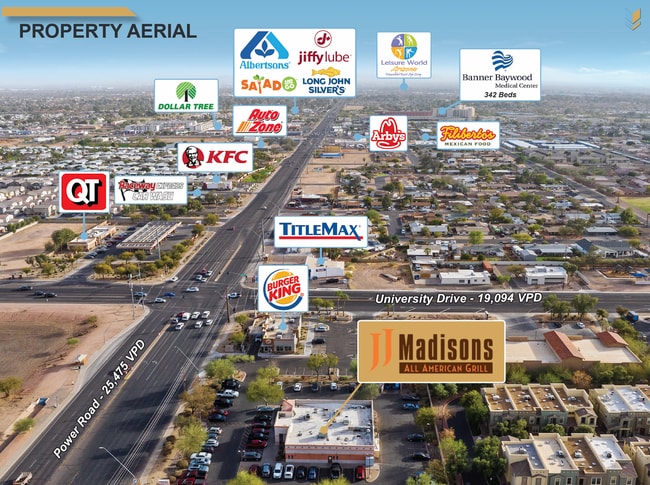
Property Record
430 N Power Rd, Mesa, AZ 85205


Property Detail
430 N Power Rd
141-62-012H
TH POR SE4 SEC 13 DAF COM AT SE COR SD SEC TH N 468.75F TH W 50F TPOB TH S 213.76F TH W 236.14F TH N 26D 43M W 11.44F TH N 203.81F TH E 241.81F TPOB EX E 25F TH/OF & EX TH PT LY W/IN P/F 98-0524337
Restaurantbuilding
Maricopa
C-C
Arizona
C and X Area of minimal flood hazard, usually depicted on FIRMs as above the 500-year flood level.
1.02 AC
2025
Red Mountain/Mesa
2025
Phoenix
420202
Phoenix-Mesa-Chandler, AZ
5,048 SF
NEARBY LISTINGS FOR SALE OR LEASE
DEMOGRAPHICS near 430 N Power Rd
1 mile
3 mile
5 mile
2025 Total Population
12,349
105,384
276,659
2030 Population
12,888
110,505
289,196
Pop Growth 2025-2030
+ 4.36%
+ 4.86%
+ 4.53%
Average Age
46
48
45
2025 Total Households
5,630
46,572
113,332
HH Growth 2025-2030
+ 4.40%
+ 5.29%
+ 4.91%
Median Household Inc
$64,583
$71,560
$80,927
Avg Household Size
2.10
2.20
2.40
2025 Avg HH Vehicles
2.00
2.00
2.00
Median Home Value
$319,096
$359,769
$404,931
Median Year Built
1988
1987
1992
Nearby Places
Map Layers
Map Styles
 Street
 Aerial
Transit
 Traffic
 Biking
Places
Listings with unknown addresses are not visible on the map
- Restaurants
- Banks
- Shops
- Fitness
- Groceries
PUBLIC TRANSPORTATION
AIRPORT
Phoenix-Mesa Gateway
Drive
Walk
Distance
Phoenix-Mesa Gateway
18 min
9.4 mi
Phoenix Sky Harbor International
Drive
Walk
Distance
Phoenix Sky Harbor International
33 min
23.8 mi
SALE & LEASE HISTORY
LISTING DATE
SALE/LEASE

Mar 10, 2025
For Sale
Jun 07, 2017
For Sale
Jan 30, 2018
For Sale
Aug 09, 2018
For Sale
Nearby Properties
Address
Land Use
TOTAL SIZE
Lot Size
Zoning
Address
Land Use
TOTAL SIZE
Lot Size
Zoning
1,522,034 SF
32.67 AC
C-N
Address
Land Use
TOTAL SIZE
Lot Size
Zoning
53,910 SF
4.98 AC
C-G
Address
Land Use
TOTAL SIZE
Lot Size
Zoning
57.25 AC
PF
Address
Land Use
TOTAL SIZE
Lot Size
Zoning
324,534 SF
50.86 AC
PF
Address
Land Use
TOTAL SIZE
Lot Size
Zoning
271,098 SF
142.75 AC
PF
Address
Land Use
TOTAL SIZE
Lot Size
Zoning
279,338 SF
39.90 AC
PF
Address
Land Use
TOTAL SIZE
Lot Size
Zoning
18.75 AC
PF
Address
Land Use
TOTAL SIZE
Lot Size
Zoning
711,933 SF
45.84 AC
Address
Land Use
TOTAL SIZE
Lot Size
Zoning
122,042 SF
15.79 AC
PF
Address
Land Use
TOTAL SIZE
Lot Size
Zoning
140,141 SF
37.70 AC
PF
Address
Land Use
TOTAL SIZE
Lot Size
Zoning
425,158 SF
23.71 AC
M-H
Address
Land Use
TOTAL SIZE
Lot Size
Zoning
219,041 SF
5.71 AC
I-1
Address
Land Use
TOTAL SIZE
Lot Size
Zoning
8.82 AC
Address
Land Use
TOTAL SIZE
Lot Size
Zoning
82,772 SF
131.12 AC
PF
Address
Land Use
TOTAL SIZE
Lot Size
Zoning
359,204 SF
40.94 AC
LI
Address
Land Use
TOTAL SIZE
Lot Size
Zoning
267,380 SF
17.08 AC
M-H
Address
Land Use
TOTAL SIZE
Lot Size
Zoning
225,660 SF
10.36 AC
M-H
Address
Land Use
TOTAL SIZE
Lot Size
Zoning
203,722 SF
11.73 AC
C-G
Address
Land Use
TOTAL SIZE
Lot Size
Zoning
7.90 AC
Address
Land Use
TOTAL SIZE
Lot Size
Zoning
214,197 SF
10.43 AC
RM3
Address
Land Use
TOTAL SIZE
Lot Size
Zoning
190,630 SF
6.61 AC
M-H
Address
Land Use
TOTAL SIZE
Lot Size
Zoning
256,284 SF
11.42 AC
M-H
Address
Land Use
TOTAL SIZE
Lot Size
Zoning
187,297 SF
3.99 AC
R-9
Address
Land Use
TOTAL SIZE
Lot Size
Zoning
7.26 AC
Address
Land Use
TOTAL SIZE
Lot Size
Zoning
94,209 SF
14.93 AC
C-G
Address
Land Use
TOTAL SIZE
Lot Size
Zoning
3,545 SF
1.14 AC
C-G
Address
Land Use
TOTAL SIZE
Lot Size
Zoning
163,562 SF
16.34 AC
Address
Land Use
TOTAL SIZE
Lot Size
Zoning
124,850 SF
12.09 AC
RM4
Address
Land Use
TOTAL SIZE
Lot Size
Zoning
308,103 SF
14.78 AC
M-H
Address
Land Use
TOTAL SIZE
Lot Size
Zoning
79,632 SF
10.54 AC
I-1
The World's #1 Commercial Real Estate Marketplace
Connect with us
© 2026 CoStar Group
The information above has been obtained from sources believed reliable. While we do not doubt its accuracy we have not verified it and make no guarantee, warranty or representation about it. It is your responsibility to independently confirm its accuracy and completeness. Any projections, opinions, assumptions, or estimates used are for example only and do not represent the current or future performance of the property. The value of this transaction to you depends on tax and other factors which should be evaluated by your tax, financial, and legal advisors. You and your advisors should conduct a careful, independent investigation of the property to determine to your satisfaction the suitability of the property for your needs.