Property Record
410 Remington Rd, Schaumburg, IL 60173
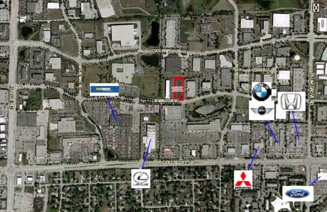
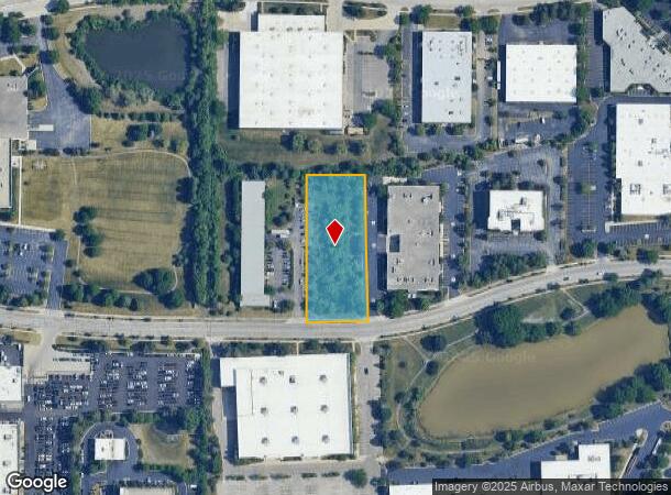
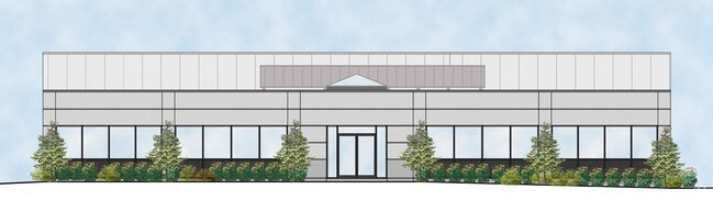
This Property Is For Sale
Current Lease Availabilities
NEARBY LISTINGS FOR SALE OR LEASE
Property Detail
410 Remington Rd
Chicago-Naperville-Elgin, IL-IN
A J
07-11-303-024-0000
Cook
Vacantlandnec
Illinois
X
b
17031C0187J
1.39 AC
2023
Northwest Cook
2025
Chicago
804603
DEMOGRAPHICS near 410 Remington Rd
1 Mile
3 Mile
5 Mile
2024 Total Population
8,043
92,518
255,436
2029 Population
7,818
89,742
247,671
Pop Growth 2024-2029
(2.80%)
(3.00%)
(3.04%)
Average Age
36
41
42
2024 Total Households
3,531
35,702
99,037
HH Growth 2024-2029
(3.09%)
(3.29%)
(3.34%)
Median Household Inc
$83,638
$91,056
$92,498
Avg Household Size
2.20
2.50
2.50
2024 Avg HH Vehicles
1.00
2.00
2.00
Median Home Value
$212,809
$317,755
$315,882
Median Year Built
1978
1976
1975
Nearby Places
Map Layers
Map Styles
 Street
 Aerial
- Restaurants
- Banks
- Shops
- Fitness
- Groceries
PUBLIC TRANSPORTATION
COMMUTER RAIL
Palatine Station (Union Pacific Northwest Line - Northeast Illinois Regional Commuter Railroad (Metra))
DRIVE
WALK
Distance
Palatine Station (Union Pacific Northwest Line - Northeast Illinois Regional Commuter Railroad (Metra))
13 min
6.2 mi
Roselle Station (Milwaukee District West Line - Northeast Illinois Regional Commuter Railroad (Metra))
DRIVE
WALK
Distance
Roselle Station (Milwaukee District West Line - Northeast Illinois Regional Commuter Railroad (Metra))
15 min
6.3 mi
AIRPORT
Chicago O'Hare International
DRIVE
WALK
Distance
Chicago O'Hare International
23 min
15.9 mi
Chicago Midway International
DRIVE
WALK
Distance
Chicago Midway International
45 min
30.0 mi
Nearby Properties
Address
Land Use
TOTAL SIZE
Lot Size
Zoning
Address
Land Use
TOTAL SIZE
Lot Size
Zoning
42.14 AC
Address
Land Use
TOTAL SIZE
Lot Size
Zoning
800,552 SF
38.86 AC
Address
Land Use
TOTAL SIZE
Lot Size
Zoning
3,464 SF
60.04 AC
Address
Land Use
TOTAL SIZE
Lot Size
Zoning
782,746 SF
12.44 AC
Address
Land Use
TOTAL SIZE
Lot Size
Zoning
300,000 SF
9.29 AC
Address
Land Use
TOTAL SIZE
Lot Size
Zoning
875,776 SF
8.73 AC
Address
Land Use
TOTAL SIZE
Lot Size
Zoning
12.66 AC
Address
Land Use
TOTAL SIZE
Lot Size
Zoning
Address
Land Use
TOTAL SIZE
Lot Size
Zoning
961,890 SF
42.21 AC
Address
Land Use
TOTAL SIZE
Lot Size
Zoning
Address
Land Use
TOTAL SIZE
Lot Size
Zoning
Address
Land Use
TOTAL SIZE
Lot Size
Zoning
510,788 SF
39.93 AC
Address
Land Use
TOTAL SIZE
Lot Size
Zoning
748,059 SF
7.36 AC
Address
Land Use
TOTAL SIZE
Lot Size
Zoning
338,694 SF
12.18 AC
Address
Land Use
TOTAL SIZE
Lot Size
Zoning
490,458 SF
13.52 AC
Address
Land Use
TOTAL SIZE
Lot Size
Zoning
365,253 SF
31.07 AC
Address
Land Use
TOTAL SIZE
Lot Size
Zoning
305,008 SF
40.11 AC
Address
Land Use
TOTAL SIZE
Lot Size
Zoning
427,761 SF
30.41 AC
Address
Land Use
TOTAL SIZE
Lot Size
Zoning
32,500 SF
2.92 AC
Address
Land Use
TOTAL SIZE
Lot Size
Zoning
302,135 SF
19.28 AC
Address
Land Use
TOTAL SIZE
Lot Size
Zoning
Address
Land Use
TOTAL SIZE
Lot Size
Zoning
300,686 SF
8.47 AC
Address
Land Use
TOTAL SIZE
Lot Size
Zoning
544,744 SF
14.87 AC
Address
Land Use
TOTAL SIZE
Lot Size
Zoning
Address
Land Use
TOTAL SIZE
Lot Size
Zoning
332,283 SF
Address
Land Use
TOTAL SIZE
Lot Size
Zoning
24.55 AC
Address
Land Use
TOTAL SIZE
Lot Size
Zoning
28,913 SF
6.63 AC
Address
Land Use
TOTAL SIZE
Lot Size
Zoning
388,080 SF
12.64 AC
Address
Land Use
TOTAL SIZE
Lot Size
Zoning
369,303 SF
29.96 AC
Address
Land Use
TOTAL SIZE
Lot Size
Zoning
325,470 SF
22.20 AC
The World's #1 Commercial Real Estate Marketplace
Connect with us
© 2026 CoStar Group
The information above has been obtained from sources believed reliable. While we do not doubt its accuracy we have not verified it and make no guarantee, warranty or representation about it. It is your responsibility to independently confirm its accuracy and completeness. Any projections, opinions, assumptions, or estimates used are for example only and do not represent the current or future performance of the property. The value of this transaction to you depends on tax and other factors which should be evaluated by your tax, financial, and legal advisors. You and your advisors should conduct a careful, independent investigation of the property to determine to your satisfaction the suitability of the property for your needs.