Property Record
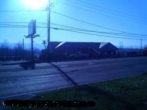
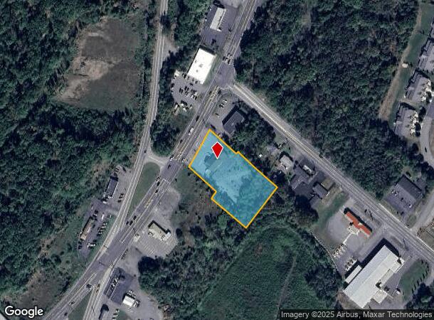
430 Scranton Cdale Highway Rte, Archbald, PA 18403
NEARBY LISTINGS FOR SALE OR LEASE
Property Detail
430 Scranton Cdale Highway Rte
Scranton--Wilkes-Barre--Hazelton, PA
Elk Hill Coal & Iron Company
09413010008
200X150 BLDG & LAND W-04 B-5350 L-000M P-00000
Taxexempt
Lackawanna
X
Pennsylvania
42069C0227D
m
2025
0.69 AC
2025
I-81 Corridor
111100
Philadelphia
DEMOGRAPHICS near 430 Scranton Cdale Highway Rte
1 Mile
3 Mile
5 Mile
2024 Total Population
2,593
27,478
46,308
2029 Population
2,550
27,094
45,792
Pop Growth 2024-2029
(1.66%)
(1.40%)
(1.11%)
Average Age
44
43
43
2024 Total Households
1,107
11,966
19,938
HH Growth 2024-2029
(1.72%)
(1.40%)
(1.12%)
Median Household Inc
$62,359
$61,870
$65,395
Avg Household Size
2.30
2.30
2.30
2024 Avg HH Vehicles
2.00
2.00
2.00
Median Home Value
$206,840
$168,797
$175,215
Median Year Built
1972
1954
1958
Nearby Places
Map Layers
Map Styles
 Street
 Aerial
- Restaurants
- Banks
- Shops
- Fitness
- Groceries
PUBLIC TRANSPORTATION
AIRPORT
Wilkes-Barre/Scranton International
DRIVE
WALK
Distance
Wilkes-Barre/Scranton International
27 min
17.4 mi
Freight Ports
Maher Terminal
DRIVE
WALK
Distance
Maher Terminal
150 min
118.4 mi
Nearby Properties
Address
Land Use
TOTAL SIZE
Lot Size
Zoning
Address
Land Use
TOTAL SIZE
Lot Size
Zoning
65.35 AC
Address
Land Use
TOTAL SIZE
Lot Size
Zoning
112.27 AC
Address
Land Use
TOTAL SIZE
Lot Size
Zoning
43.89 AC
Address
Land Use
TOTAL SIZE
Lot Size
Zoning
135.22 AC
Address
Land Use
TOTAL SIZE
Lot Size
Zoning
38.12 AC
Address
Land Use
TOTAL SIZE
Lot Size
Zoning
29.58 AC
Address
Land Use
TOTAL SIZE
Lot Size
Zoning
99.18 AC
Address
Land Use
TOTAL SIZE
Lot Size
Zoning
10.10 AC
Address
Land Use
TOTAL SIZE
Lot Size
Zoning
7.30 AC
Address
Land Use
TOTAL SIZE
Lot Size
Zoning
44.05 AC
Address
Land Use
TOTAL SIZE
Lot Size
Zoning
27.39 AC
Address
Land Use
TOTAL SIZE
Lot Size
Zoning
4.96 AC
Address
Land Use
TOTAL SIZE
Lot Size
Zoning
18.30 AC
Address
Land Use
TOTAL SIZE
Lot Size
Zoning
1.68 AC
Address
Land Use
TOTAL SIZE
Lot Size
Zoning
5.35 AC
Address
Land Use
TOTAL SIZE
Lot Size
Zoning
9.70 AC
Address
Land Use
TOTAL SIZE
Lot Size
Zoning
14.41 AC
Address
Land Use
TOTAL SIZE
Lot Size
Zoning
10.38 AC
Address
Land Use
TOTAL SIZE
Lot Size
Zoning
18.61 AC
Address
Land Use
TOTAL SIZE
Lot Size
Zoning
1.80 AC
Address
Land Use
TOTAL SIZE
Lot Size
Zoning
2,428 SF
357.58 AC
Address
Land Use
TOTAL SIZE
Lot Size
Zoning
13.64 AC
Address
Land Use
TOTAL SIZE
Lot Size
Zoning
10.24 AC
Address
Land Use
TOTAL SIZE
Lot Size
Zoning
Address
Land Use
TOTAL SIZE
Lot Size
Zoning
Address
Land Use
TOTAL SIZE
Lot Size
Zoning
6.20 AC
Address
Land Use
TOTAL SIZE
Lot Size
Zoning
0.47 AC
Address
Land Use
TOTAL SIZE
Lot Size
Zoning
0.95 AC
Address
Land Use
TOTAL SIZE
Lot Size
Zoning
8.51 AC
Address
Land Use
TOTAL SIZE
Lot Size
Zoning
0.17 AC
The World's #1 Commercial Real Estate Marketplace
Connect with us
© 2025 CoStar Group
The information above has been obtained from sources believed reliable. While we do not doubt its accuracy we have not verified it and make no guarantee, warranty or representation about it. It is your responsibility to independently confirm its accuracy and completeness. Any projections, opinions, assumptions, or estimates used are for example only and do not represent the current or future performance of the property. The value of this transaction to you depends on tax and other factors which should be evaluated by your tax, financial, and legal advisors. You and your advisors should conduct a careful, independent investigation of the property to determine to your satisfaction the suitability of the property for your needs.