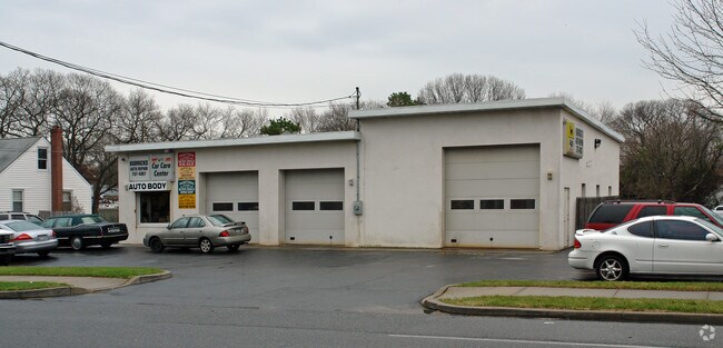
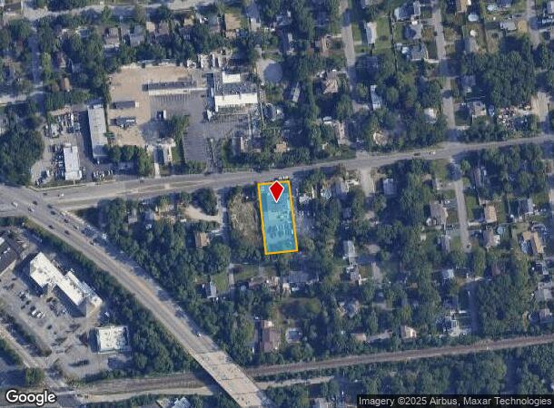
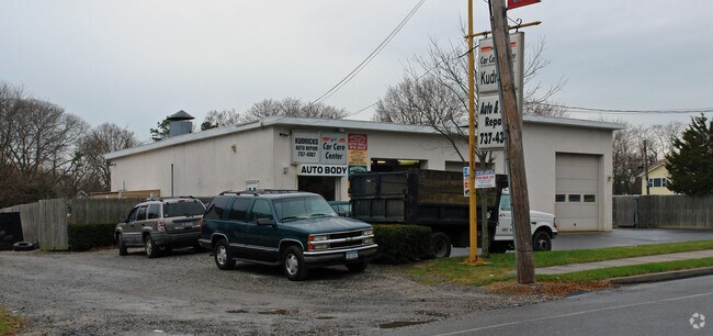
Property Record
430 Union Ave, Holbrook, NY 11741
NEARBY LISTINGS FOR SALE OR LEASE
Property Detail
430 Union Ave
Nassau County-Suffolk County, NY
Sunset Farms
0200-764-00-04-00-056-001
SUNSET FARM 1247 21 TO 25 & 51 TO 5
Autorepair
Suffolk
X
New York
36103C0690H
56
2024
0.60 AC
2024
Central Suffolk
158605
Long Island (New York)
DEMOGRAPHICS near 430 Union Ave
1 Mile
3 Mile
5 Mile
2024 Total Population
9,103
80,656
229,923
2029 Population
8,937
79,562
226,716
Pop Growth 2024-2029
(1.82%)
(1.36%)
(1.39%)
Average Age
42
41
41
2024 Total Households
2,911
27,384
79,554
HH Growth 2024-2029
(2.06%)
(1.51%)
(1.55%)
Median Household Inc
$131,895
$122,419
$113,734
Avg Household Size
3.10
2.90
2.80
2024 Avg HH Vehicles
2.00
2.00
2.00
Median Home Value
$449,499
$445,035
$447,677
Median Year Built
1971
1972
1971
Nearby Places
- Restaurants
- Banks
- Shops
- Fitness
- Groceries
PUBLIC TRANSPORTATION
COMMUTER RAIL
Ronkonkoma Station (Greenport Branch - Long Island Rail Road, Ronkonkoma Branch - Long Island Rail Road)
DRIVE
WALK
Distance
Ronkonkoma Station (Greenport Branch - Long Island Rail Road, Ronkonkoma Branch - Long Island Rail Road)
5 min
1.9 mi
Patchogue Station (Montauk Branch - Long Island Rail Road)
DRIVE
WALK
Distance
Patchogue Station (Montauk Branch - Long Island Rail Road)
11 min
5.5 mi
AIRPORT
Long Island MacArthur
DRIVE
WALK
Distance
Long Island MacArthur
12 min
4.2 mi
Nearby Properties
Address
Land Use
TOTAL SIZE
Lot Size
Zoning
Address
Land Use
TOTAL SIZE
Lot Size
Zoning
1,207.60 AC
Address
Land Use
TOTAL SIZE
Lot Size
Zoning
30.25 AC
CA
Address
Land Use
TOTAL SIZE
Lot Size
Zoning
95.19 AC
Address
Land Use
TOTAL SIZE
Lot Size
Zoning
29.86 AC
CA
Address
Land Use
TOTAL SIZE
Lot Size
Zoning
26.28 AC
CA
Address
Land Use
TOTAL SIZE
Lot Size
Zoning
23.50 AC
AA
Address
Land Use
TOTAL SIZE
Lot Size
Zoning
18.68 AC
IND1
Address
Land Use
TOTAL SIZE
Lot Size
Zoning
96 SF
18.29 AC
BUS3
Address
Land Use
TOTAL SIZE
Lot Size
Zoning
12.70 AC
IND1
Address
Land Use
TOTAL SIZE
Lot Size
Zoning
25.90 AC
Address
Land Use
TOTAL SIZE
Lot Size
Zoning
42.37 AC
Address
Land Use
TOTAL SIZE
Lot Size
Zoning
140.10 AC
Address
Land Use
TOTAL SIZE
Lot Size
Zoning
14.73 AC
AA
Address
Land Use
TOTAL SIZE
Lot Size
Zoning
11.19 AC
Address
Land Use
TOTAL SIZE
Lot Size
Zoning
16.90 AC
AA
Address
Land Use
TOTAL SIZE
Lot Size
Zoning
19.70 AC
AA
Address
Land Use
TOTAL SIZE
Lot Size
Zoning
14.70 AC
BUS3
Address
Land Use
TOTAL SIZE
Lot Size
Zoning
14.48 AC
IND1
Address
Land Use
TOTAL SIZE
Lot Size
Zoning
6.50 AC
GSE
Address
Land Use
TOTAL SIZE
Lot Size
Zoning
17.52 AC
ICD
Address
Land Use
TOTAL SIZE
Lot Size
Zoning
Address
Land Use
TOTAL SIZE
Lot Size
Zoning
14.75 AC
CA
Address
Land Use
TOTAL SIZE
Lot Size
Zoning
15.80 AC
ICD
Address
Land Use
TOTAL SIZE
Lot Size
Zoning
10.99 AC
Address
Land Use
TOTAL SIZE
Lot Size
Zoning
12.32 AC
IND1
Address
Land Use
TOTAL SIZE
Lot Size
Zoning
4.23 AC
IND1
Address
Land Use
TOTAL SIZE
Lot Size
Zoning
10.92 AC
ICD
Address
Land Use
TOTAL SIZE
Lot Size
Zoning
8.10 AC
GSC
Address
Land Use
TOTAL SIZE
Lot Size
Zoning
6.03 AC
IND1
Address
Land Use
TOTAL SIZE
Lot Size
Zoning
6,486 SF
0.55 AC
VILLA
The World's #1 Commercial Real Estate Marketplace
Connect with us
© 2025 CoStar Group
The information above has been obtained from sources believed reliable. While we do not doubt its accuracy we have not verified it and make no guarantee, warranty or representation about it. It is your responsibility to independently confirm its accuracy and completeness. Any projections, opinions, assumptions, or estimates used are for example only and do not represent the current or future performance of the property. The value of this transaction to you depends on tax and other factors which should be evaluated by your tax, financial, and legal advisors. You and your advisors should conduct a careful, independent investigation of the property to determine to your satisfaction the suitability of the property for your needs.