Property Record
430 W Jackson St, Willard, MO 65781
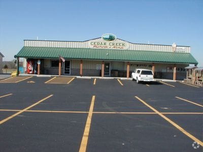

Property Detail
430 W Jackson St
07-22-400-033
FOXFIRE (REPL LOTS 1 & 2) LOT 1B
Storebuilding
Greene
INC
Missouri
B and X Area of moderate flood hazard, usually the area between the limits of the 100-year and 500-year floods.
2,1b
2025
0.78 AC
2025
Outlying Greene County
005002
Springfield
3,200 SF
Springfield, MO
NEARBY LISTINGS FOR SALE OR LEASE
-
-
View all Willard listings for sale on LoopNet.com
DEMOGRAPHICS near 430 W Jackson St
1 mile
3 mile
5 mile
2025 Total Population
1,674
7,420
11,692
2030 Population
1,724
7,640
11,989
Pop Growth 2025-2030
+ 2.99%
+ 2.96%
+ 2.54%
Average Age
38
38
39
2025 Total Households
585
2,726
4,383
HH Growth 2025-2030
+ 3.25%
+ 3.12%
+ 2.69%
Median Household Inc
$116,841
$95,958
$85,989
Avg Household Size
2.80
2.70
2.60
2025 Avg HH Vehicles
2.00
2.00
2.00
Median Home Value
$251,865
$250,302
$266,766
Median Year Built
1993
1990
1988
Nearby Places
Map Layers
Map Styles
 Street
 Aerial
Transit
 Traffic
 Biking
Places
Listings with unknown addresses are not visible on the map
- Restaurants
- Banks
- Shops
- Fitness
- Groceries
PUBLIC TRANSPORTATION
AIRPORT
Springfield-Branson Ntl
Drive
Walk
Distance
Springfield-Branson Ntl
14 min
7.0 mi
Nearby Properties
Address
Land Use
TOTAL SIZE
Lot Size
Zoning
Address
Land Use
TOTAL SIZE
Lot Size
Zoning
10.70 AC
INC
Address
Land Use
TOTAL SIZE
Lot Size
Zoning
5.71 AC
INC
Address
Land Use
TOTAL SIZE
Lot Size
Zoning
49,860 SF
5.34 AC
INC
Address
Land Use
TOTAL SIZE
Lot Size
Zoning
2,733 SF
4.49 AC
INC
Address
Land Use
TOTAL SIZE
Lot Size
Zoning
25,046 SF
6.37 AC
INC
Address
Land Use
TOTAL SIZE
Lot Size
Zoning
2 AC
INC
Address
Land Use
TOTAL SIZE
Lot Size
Zoning
24,695 SF
3.36 AC
INC
Address
Land Use
TOTAL SIZE
Lot Size
Zoning
1.62 AC
INC
Address
Land Use
TOTAL SIZE
Lot Size
Zoning
1.19 AC
INC
Address
Land Use
TOTAL SIZE
Lot Size
Zoning
1,335 SF
1.07 AC
INC
Address
Land Use
TOTAL SIZE
Lot Size
Zoning
Address
Land Use
TOTAL SIZE
Lot Size
Zoning
5,090 SF
1.35 AC
INC
Address
Land Use
TOTAL SIZE
Lot Size
Zoning
Address
Land Use
TOTAL SIZE
Lot Size
Zoning
0.77 AC
INC
Address
Land Use
TOTAL SIZE
Lot Size
Zoning
4,076 SF
1.05 AC
INC
Address
Land Use
TOTAL SIZE
Lot Size
Zoning
3.04 AC
INC
Address
Land Use
TOTAL SIZE
Lot Size
Zoning
7,500 SF
2.16 AC
INC
Address
Land Use
TOTAL SIZE
Lot Size
Zoning
1,960 SF
0.69 AC
INC
Address
Land Use
TOTAL SIZE
Lot Size
Zoning
1.05 AC
Address
Land Use
TOTAL SIZE
Lot Size
Zoning
2,888 SF
4.40 AC
INC
Address
Land Use
TOTAL SIZE
Lot Size
Zoning
0.80 AC
INC
Address
Land Use
TOTAL SIZE
Lot Size
Zoning
6,726 SF
0.98 AC
INC
Address
Land Use
TOTAL SIZE
Lot Size
Zoning
7,920 SF
133 AC
A-1
Address
Land Use
TOTAL SIZE
Lot Size
Zoning
9,200 SF
0.59 AC
INC
Address
Land Use
TOTAL SIZE
Lot Size
Zoning
1.04 AC
INC
Address
Land Use
TOTAL SIZE
Lot Size
Zoning
0.53 AC
INC
Address
Land Use
TOTAL SIZE
Lot Size
Zoning
8.42 AC
Address
Land Use
TOTAL SIZE
Lot Size
Zoning
8,471 SF
150 AC
Address
Land Use
TOTAL SIZE
Lot Size
Zoning
2,829 SF
0.72 AC
INC
Address
Land Use
TOTAL SIZE
Lot Size
Zoning
3,352 SF
0.81 AC
INC
The World's #1 Commercial Real Estate Marketplace
Connect with us
© 2026 CoStar Group
The information above has been obtained from sources believed reliable. While we do not doubt its accuracy we have not verified it and make no guarantee, warranty or representation about it. It is your responsibility to independently confirm its accuracy and completeness. Any projections, opinions, assumptions, or estimates used are for example only and do not represent the current or future performance of the property. The value of this transaction to you depends on tax and other factors which should be evaluated by your tax, financial, and legal advisors. You and your advisors should conduct a careful, independent investigation of the property to determine to your satisfaction the suitability of the property for your needs.