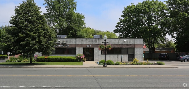
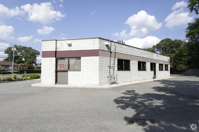
Property Record
430 W Main St, Babylon, NY 11702

Save to a Folder
{{folder.Name}}
{{folder.ListingIds.length}} Properties
{{folder.ListingIds.length}} Property
Create a New Folder
Property Detail
430 W Main St
Nassau County-Suffolk County, NY
FILED MAP 812 LOTS 11-16 INC.
0102-012-00-02-00-032-001
Suffolk
Financialbuilding
New York
B and X Area of moderate flood hazard, usually the area between the limits of the 100-year and 500-year floods.
32
2024
0.30 AC
2025
Southwestern Suffolk
159109
Long Island (New York)
2,964 SF
NEARBY LISTINGS FOR SALE OR LEASE
-
-
-
-
-
-
No Photo
-
-
View all Babylon listings for lease on LoopNet.com
DEMOGRAPHICS near 430 W Main St
1 mile
3 mile
5 mile
2025 Total Population
13,998
107,659
237,299
2030 Population
13,926
105,839
233,778
Pop Growth 2025-2030
(0.51%)
(1.69%)
(1.48%)
Average Age
44
42
41
2025 Total Households
5,407
36,608
77,563
HH Growth 2025-2030
(1.00%)
(1.97%)
(1.70%)
Median Household Inc
$114,783
$132,778
$125,972
Avg Household Size
2.50
2.80
2.90
2025 Avg HH Vehicles
2.00
2.00
2.00
Median Home Value
$681,684
$624,113
$584,085
Median Year Built
1960
1959
1961
Nearby Places
Map Layers
Map Styles
 Street
 Aerial
Layers
 Traffic
 Biking
Places
Listings with unknown addresses are not visible on the map
- Restaurants
- Banks
- Shops
- Fitness
- Groceries
PUBLIC TRANSPORTATION
COMMUTER RAIL
Babylon Station (Babylon Branch - Long Island Rail Road, Montauk Branch - Long Island Rail Road)
Drive
Walk
Distance
Babylon Station (Babylon Branch - Long Island Rail Road, Montauk Branch - Long Island Rail Road)
3 min
1.1 mi
Lindenhurst Station (Babylon Branch - Long Island Rail Road)
Drive
Walk
Distance
Lindenhurst Station (Babylon Branch - Long Island Rail Road)
5 min
2.3 mi
AIRPORT
Long Island MacArthur
Drive
Walk
Distance
Long Island MacArthur
26 min
17.2 mi
John F Kennedy International
Drive
Walk
Distance
John F Kennedy International
41 min
28.3 mi
LaGuardia
Drive
Walk
Distance
LaGuardia
51 min
35.3 mi
Freight Ports
NY - Red Hook Container Terminal
Drive
Walk
Distance
NY - Red Hook Container Terminal
62 min
39.7 mi
SALE & LEASE HISTORY
LISTING DATE
SALE/LEASE

Jun 21, 2017
For Lease
Nearby Properties
Address
Land Use
TOTAL SIZE
Lot Size
Zoning
Address
Land Use
TOTAL SIZE
Lot Size
Zoning
48.97 AC
GSC
Address
Land Use
TOTAL SIZE
Lot Size
Zoning
256 SF
24.20 AC
GSC
Address
Land Use
TOTAL SIZE
Lot Size
Zoning
20 AC
A
Address
Land Use
TOTAL SIZE
Lot Size
Zoning
10.07 AC
Address
Land Use
TOTAL SIZE
Lot Size
Zoning
20.50 AC
B
Address
Land Use
TOTAL SIZE
Lot Size
Zoning
20.10 AC
A
Address
Land Use
TOTAL SIZE
Lot Size
Zoning
4,290 SF
1.50 AC
VILLA
Address
Land Use
TOTAL SIZE
Lot Size
Zoning
18.70 AC
A
Address
Land Use
TOTAL SIZE
Lot Size
Zoning
14.60 AC
A
Address
Land Use
TOTAL SIZE
Lot Size
Zoning
9.70 AC
B
Address
Land Use
TOTAL SIZE
Lot Size
Zoning
19.40 AC
IND1
Address
Land Use
TOTAL SIZE
Lot Size
Zoning
11 AC
B
Address
Land Use
TOTAL SIZE
Lot Size
Zoning
7.50 AC
B
Address
Land Use
TOTAL SIZE
Lot Size
Zoning
6.37 AC
BUS1
Address
Land Use
TOTAL SIZE
Lot Size
Zoning
6.37 AC
BUS3
Address
Land Use
TOTAL SIZE
Lot Size
Zoning
1.82 AC
Address
Land Use
TOTAL SIZE
Lot Size
Zoning
15.60 AC
A
Address
Land Use
TOTAL SIZE
Lot Size
Zoning
3.91 AC
IND1
Address
Land Use
TOTAL SIZE
Lot Size
Zoning
4.15 AC
BUS1
Address
Land Use
TOTAL SIZE
Lot Size
Zoning
2.40 AC
A
Address
Land Use
TOTAL SIZE
Lot Size
Zoning
3.04 AC
BUS1
Address
Land Use
TOTAL SIZE
Lot Size
Zoning
5,010 SF
0.30 AC
R10
Address
Land Use
TOTAL SIZE
Lot Size
Zoning
3.01 AC
BUS1
Address
Land Use
TOTAL SIZE
Lot Size
Zoning
4.06 AC
BUS1
Address
Land Use
TOTAL SIZE
Lot Size
Zoning
2.69 AC
BUS1
Address
Land Use
TOTAL SIZE
Lot Size
Zoning
2.38 AC
Address
Land Use
TOTAL SIZE
Lot Size
Zoning
3.55 AC
BUS1
Address
Land Use
TOTAL SIZE
Lot Size
Zoning
3.44 AC
AA
Address
Land Use
TOTAL SIZE
Lot Size
Zoning
0.65 AC
R40
Address
Land Use
TOTAL SIZE
Lot Size
Zoning
The World's #1 Commercial Real Estate Marketplace
Connect with us
© 2026 CoStar Group
The information above has been obtained from sources believed reliable. While we do not doubt its accuracy we have not verified it and make no guarantee, warranty or representation about it. It is your responsibility to independently confirm its accuracy and completeness. Any projections, opinions, assumptions, or estimates used are for example only and do not represent the current or future performance of the property. The value of this transaction to you depends on tax and other factors which should be evaluated by your tax, financial, and legal advisors. You and your advisors should conduct a careful, independent investigation of the property to determine to your satisfaction the suitability of the property for your needs.