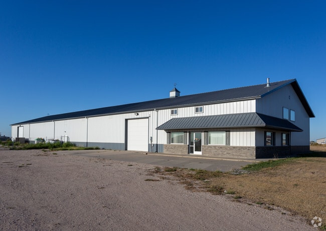
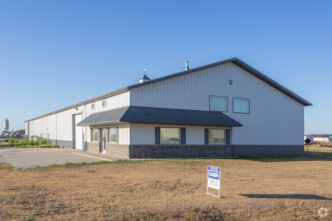
Property Record
4300 Chambers Dr, Garden City, KS 67846

NEARBY LISTINGS FOR SALE OR LEASE
Property Detail
4300 Chambers Dr
Other Market Areas
Airlinks Industrial Park Replat
Garden City, KS
AIRLINKS INDUSTRIAL PARK REPLAT LOTS 4, 10, & 16, S15, T24, R32W, LOT 10, ACRES 2.2, TR BEG NW COR TH E 246.8' TH S 388.1' TH
275-15-0-00-07-002.06-0
Finney
Lightindustrial
Kansas
2025
4,10
2025
2.20 AC
960501
Kansas Area
15,195 SF
DEMOGRAPHICS near 4300 Chambers Dr
1 Mile
3 Mile
5 Mile
2024 Total Population
3,962
19,723
31,687
2029 Population
3,856
19,094
30,723
Pop Growth 2024-2029
(2.68%)
(3.19%)
(3.04%)
Average Age
31
35
35
2024 Total Households
1,183
6,809
10,847
HH Growth 2024-2029
(2.54%)
(3.20%)
(3.07%)
Median Household Inc
$55,789
$60,725
$63,554
Avg Household Size
3.20
2.80
2.80
2024 Avg HH Vehicles
3.00
2.00
2.00
Median Home Value
$77,638
$165,632
$163,818
Median Year Built
1989
1977
1976
Nearby Places
Map Layers
Map Styles
 Street
 Aerial
- Restaurants
- Banks
- Shops
- Fitness
- Groceries
PUBLIC TRANSPORTATION
COMMUTER RAIL
Garden City Amtrak Station (Southwest Chief - Amtrak)
DRIVE
WALK
Distance
Garden City Amtrak Station (Southwest Chief - Amtrak)
8 min
3.9 mi
Freight Ports
Tulsa Port Of Catoosa
DRIVE
WALK
Distance
Tulsa Port Of Catoosa
450 min
392.5 mi
SALE & LEASE HISTORY
LISTING DATE
SALE/LEASE

Oct 09, 2019
For Sale
Oct 09, 2019
For Lease
Nov 15, 2017
For Sale
Nearby Properties
Address
Land Use
TOTAL SIZE
Lot Size
Zoning
Address
Land Use
TOTAL SIZE
Lot Size
Zoning
485,653 SF
107.22 AC
Address
Land Use
TOTAL SIZE
Lot Size
Zoning
21,733 SF
60.54 AC
PF
Address
Land Use
TOTAL SIZE
Lot Size
Zoning
182,177 SF
22.83 AC
R2
Address
Land Use
TOTAL SIZE
Lot Size
Zoning
73,757 SF
25.61 AC
A
Address
Land Use
TOTAL SIZE
Lot Size
Zoning
6,300 SF
55.93 AC
Address
Land Use
TOTAL SIZE
Lot Size
Zoning
90,384 SF
27.14 AC
R2
Address
Land Use
TOTAL SIZE
Lot Size
Zoning
2,720 SF
13.43 AC
A
Address
Land Use
TOTAL SIZE
Lot Size
Zoning
39,413 SF
7.39 AC
R1
Address
Land Use
TOTAL SIZE
Lot Size
Zoning
38,151 SF
9.04 AC
R3
Address
Land Use
TOTAL SIZE
Lot Size
Zoning
37,343 SF
12.42 AC
A
Address
Land Use
TOTAL SIZE
Lot Size
Zoning
64,065 SF
7.91 AC
R1
Address
Land Use
TOTAL SIZE
Lot Size
Zoning
69,088 SF
13.95 AC
A
Address
Land Use
TOTAL SIZE
Lot Size
Zoning
21,875 SF
17.05 AC
I3
Address
Land Use
TOTAL SIZE
Lot Size
Zoning
28,917 SF
3.99 AC
A
Address
Land Use
TOTAL SIZE
Lot Size
Zoning
64,277 SF
4.97 AC
R2
Address
Land Use
TOTAL SIZE
Lot Size
Zoning
60,280 SF
15.25 AC
A
Address
Land Use
TOTAL SIZE
Lot Size
Zoning
182,192 SF
24.54 AC
Address
Land Use
TOTAL SIZE
Lot Size
Zoning
51,489 SF
3.34 AC
R2
Address
Land Use
TOTAL SIZE
Lot Size
Zoning
121,301 SF
15.46 AC
A
Address
Land Use
TOTAL SIZE
Lot Size
Zoning
21,794 SF
3.12 AC
Address
Land Use
TOTAL SIZE
Lot Size
Zoning
46,619 SF
3.46 AC
R1
Address
Land Use
TOTAL SIZE
Lot Size
Zoning
17,176 SF
1.93 AC
C2
Address
Land Use
TOTAL SIZE
Lot Size
Zoning
4,545 SF
13.83 AC
I2
Address
Land Use
TOTAL SIZE
Lot Size
Zoning
18,950 SF
1.98 AC
R2
Address
Land Use
TOTAL SIZE
Lot Size
Zoning
30,104 SF
7.30 AC
Address
Land Use
TOTAL SIZE
Lot Size
Zoning
10,200 SF
83.93 AC
PF
Address
Land Use
TOTAL SIZE
Lot Size
Zoning
173,810 SF
18.33 AC
Address
Land Use
TOTAL SIZE
Lot Size
Zoning
204,578 SF
28.50 AC
GC
Address
Land Use
TOTAL SIZE
Lot Size
Zoning
10,146 SF
7.58 AC
Address
Land Use
TOTAL SIZE
Lot Size
Zoning
2,440 SF
3.32 AC
R1
The World's #1 Commercial Real Estate Marketplace
Connect with us
© 2026 CoStar Group
The information above has been obtained from sources believed reliable. While we do not doubt its accuracy we have not verified it and make no guarantee, warranty or representation about it. It is your responsibility to independently confirm its accuracy and completeness. Any projections, opinions, assumptions, or estimates used are for example only and do not represent the current or future performance of the property. The value of this transaction to you depends on tax and other factors which should be evaluated by your tax, financial, and legal advisors. You and your advisors should conduct a careful, independent investigation of the property to determine to your satisfaction the suitability of the property for your needs.