Property Record
362 County Road 60 Schovajsa Rd, Rosharon, TX 77583


NEARBY LISTINGS FOR SALE OR LEASE
-
-
View all Rosharon listings for sale on LoopNet.com
Property Detail
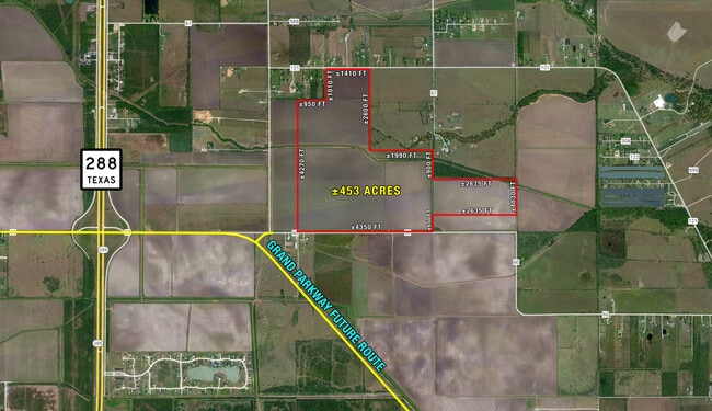
362 County Road 60 Schovajsa Rd
Houston-The Woodlands-Sugar Land, TX
H T & B R R
0256-0003-001
A0256 H T & B R R TRACT 1C ACRES 382.000
Agriculturalland
Brazoria
AE
Texas
48039C0120K
382 AC
2024
South Hwy 35
2025
Houston
661902
DEMOGRAPHICS near 362 County Road 60 Schovajsa Rd
1 Mile
3 Mile
5 Mile
2024 Total Population
68
3,245
18,462
2029 Population
79
3,721
21,339
Pop Growth 2024-2029
+ 16.18%
+ 14.67%
+ 15.58%
Average Age
37
37
36
2024 Total Households
22
1,015
5,863
HH Growth 2024-2029
+ 18.18%
+ 14.98%
+ 15.76%
Median Household Inc
$112,500
$86,017
$88,833
Avg Household Size
2.90
3.10
3.10
2024 Avg HH Vehicles
2.00
2.00
2.00
Median Home Value
$369,999
$346,842
$321,551
Median Year Built
2011
2010
2010
Nearby Places
Map Layers
Map Styles
 Street
 Aerial
- Restaurants
- Banks
- Shops
- Fitness
- Groceries
PUBLIC TRANSPORTATION
AIRPORT
William P Hobby
DRIVE
WALK
Distance
William P Hobby
41 min
26.5 mi
Freight Ports
Port of Houston
DRIVE
WALK
Distance
Port of Houston
46 min
33.3 mi
SALE & LEASE HISTORY
LISTING DATE
SALE/LEASE

Jul 20, 2023
For Sale
Nearby Properties
Address
Land Use
TOTAL SIZE
Lot Size
Zoning
Address
Land Use
TOTAL SIZE
Lot Size
Zoning
170.62 AC
Address
Land Use
TOTAL SIZE
Lot Size
Zoning
Address
Land Use
TOTAL SIZE
Lot Size
Zoning
14,978 SF
125.42 AC
0001
Address
Land Use
TOTAL SIZE
Lot Size
Zoning
Address
Land Use
TOTAL SIZE
Lot Size
Zoning
3.53 AC
Address
Land Use
TOTAL SIZE
Lot Size
Zoning
10,545 SF
2.75 AC
Address
Land Use
TOTAL SIZE
Lot Size
Zoning
16,018 SF
18 AC
Address
Land Use
TOTAL SIZE
Lot Size
Zoning
1,176 SF
87.64 AC
0001
Address
Land Use
TOTAL SIZE
Lot Size
Zoning
207.90 AC
Address
Land Use
TOTAL SIZE
Lot Size
Zoning
7,200 SF
1.91 AC
0011
Address
Land Use
TOTAL SIZE
Lot Size
Zoning
10.40 AC
Address
Land Use
TOTAL SIZE
Lot Size
Zoning
17,800 SF
2.36 AC
Address
Land Use
TOTAL SIZE
Lot Size
Zoning
19,001 SF
113.20 AC
0007
Address
Land Use
TOTAL SIZE
Lot Size
Zoning
3,769 SF
117.39 AC
0001
Address
Land Use
TOTAL SIZE
Lot Size
Zoning
4,500 SF
4.54 AC
Address
Land Use
TOTAL SIZE
Lot Size
Zoning
9,150 SF
21.25 AC
Address
Land Use
TOTAL SIZE
Lot Size
Zoning
362.31 AC
002
Address
Land Use
TOTAL SIZE
Lot Size
Zoning
10,000 SF
1.70 AC
Address
Land Use
TOTAL SIZE
Lot Size
Zoning
47.47 AC
Address
Land Use
TOTAL SIZE
Lot Size
Zoning
1,895 SF
94.08 AC
0009
Address
Land Use
TOTAL SIZE
Lot Size
Zoning
4,541 SF
13.10 AC
0011
Address
Land Use
TOTAL SIZE
Lot Size
Zoning
Address
Land Use
TOTAL SIZE
Lot Size
Zoning
749.85 AC
0021
Address
Land Use
TOTAL SIZE
Lot Size
Zoning
24.41 AC
0007
Address
Land Use
TOTAL SIZE
Lot Size
Zoning
39.81 AC
Address
Land Use
TOTAL SIZE
Lot Size
Zoning
4,567 SF
4.86 AC
0002
Address
Land Use
TOTAL SIZE
Lot Size
Zoning
5,238 SF
2 AC
0111
Address
Land Use
TOTAL SIZE
Lot Size
Zoning
84.99 AC
0001
Address
Land Use
TOTAL SIZE
Lot Size
Zoning
5,544 SF
3.48 AC
0008
The World's #1 Commercial Real Estate Marketplace
Connect with us
© 2026 CoStar Group
The information above has been obtained from sources believed reliable. While we do not doubt its accuracy we have not verified it and make no guarantee, warranty or representation about it. It is your responsibility to independently confirm its accuracy and completeness. Any projections, opinions, assumptions, or estimates used are for example only and do not represent the current or future performance of the property. The value of this transaction to you depends on tax and other factors which should be evaluated by your tax, financial, and legal advisors. You and your advisors should conduct a careful, independent investigation of the property to determine to your satisfaction the suitability of the property for your needs.