Property Record
4300 E Broad River Rd, Columbia, SC 29210
NEARBY LISTINGS FOR SALE OR LEASE
-
-
View all Columbia listings for sale on LoopNet.com
Property Detail
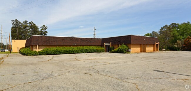
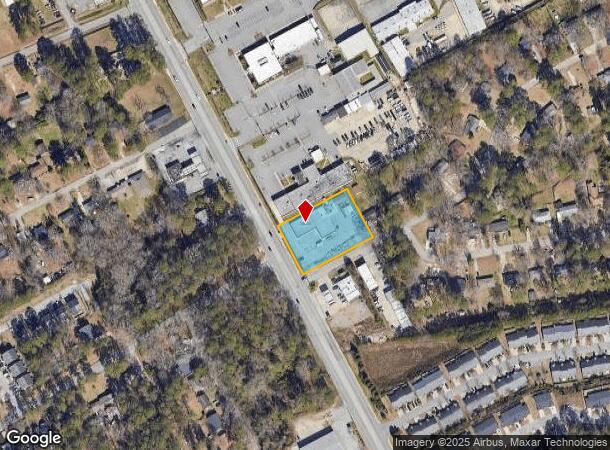
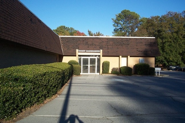
4300 E Broad River Rd
06108-05-02
Suggested Subdivision Property Of C Heat
Commercialnec
175X247.5X175X247.5 #SU MANDEL HALL #PR 8-462 463 11-83
X
Richland
45079C0228L
South Carolina
2024
1.12 AC
2023
St Andrews
010408
Columbia
8,000 SF
Columbia, SC
DEMOGRAPHICS near 4300 E Broad River Rd
1 Mile
3 Mile
5 Mile
2024 Total Population
11,314
45,659
101,649
2029 Population
11,432
47,286
105,933
Pop Growth 2024-2029
+ 1.04%
+ 3.56%
+ 4.21%
Average Age
37
38
39
2024 Total Households
3,187
19,151
43,715
HH Growth 2024-2029
+ 1.73%
+ 3.89%
+ 4.39%
Median Household Inc
$37,960
$46,552
$53,279
Avg Household Size
2.10
2.10
2.20
2024 Avg HH Vehicles
1.00
2.00
2.00
Median Home Value
$88,414
$144,810
$167,647
Median Year Built
1978
1977
1979
Nearby Places
Map Layers
Map Styles
 Street
 Aerial
- Restaurants
- Banks
- Shops
- Fitness
- Groceries
PUBLIC TRANSPORTATION
COMMUTER RAIL
DRIVE
WALK
Distance
15 min
8.4 mi
AIRPORT
Columbia Metro
DRIVE
WALK
Distance
Columbia Metro
26 min
13.2 mi
Nearby Properties
Address
Land Use
TOTAL SIZE
Lot Size
Zoning
Address
Land Use
TOTAL SIZE
Lot Size
Zoning
24.90 AC
PD
Address
Land Use
TOTAL SIZE
Lot Size
Zoning
128,160 SF
9.31 AC
RM-HD
Address
Land Use
TOTAL SIZE
Lot Size
Zoning
128,877 SF
24.71 AC
RM-HD
Address
Land Use
TOTAL SIZE
Lot Size
Zoning
370,876 SF
14.43 AC
PD
Address
Land Use
TOTAL SIZE
Lot Size
Zoning
9,620 SF
18.91 AC
GC
Address
Land Use
TOTAL SIZE
Lot Size
Zoning
183,392 SF
14.77 AC
RM-HD
Address
Land Use
TOTAL SIZE
Lot Size
Zoning
302,835 SF
11.48 AC
PD
Address
Land Use
TOTAL SIZE
Lot Size
Zoning
241,756 SF
14.25 AC
PD
Address
Land Use
TOTAL SIZE
Lot Size
Zoning
1,549.59 AC
T/C
Address
Land Use
TOTAL SIZE
Lot Size
Zoning
215,796 SF
12.71 AC
PD
Address
Land Use
TOTAL SIZE
Lot Size
Zoning
278,912 SF
23.24 AC
RM-HD
Address
Land Use
TOTAL SIZE
Lot Size
Zoning
207,112 SF
16.86 AC
RM-HD
Address
Land Use
TOTAL SIZE
Lot Size
Zoning
161,636 SF
12.38 AC
RM-HD
Address
Land Use
TOTAL SIZE
Lot Size
Zoning
208,688 SF
13.02 AC
RM-HD
Address
Land Use
TOTAL SIZE
Lot Size
Zoning
73,380 SF
16.07 AC
PDD
Address
Land Use
TOTAL SIZE
Lot Size
Zoning
2,268 SF
27.70 AC
RM-1
Address
Land Use
TOTAL SIZE
Lot Size
Zoning
129,108 SF
11.90 AC
RM-HD
Address
Land Use
TOTAL SIZE
Lot Size
Zoning
195,550 SF
17.19 AC
GC
Address
Land Use
TOTAL SIZE
Lot Size
Zoning
169,278 SF
12.21 AC
RM-HD
Address
Land Use
TOTAL SIZE
Lot Size
Zoning
153,272 SF
9.63 AC
RM-HD
Address
Land Use
TOTAL SIZE
Lot Size
Zoning
100 SF
465.41 AC
INS-GEN
Address
Land Use
TOTAL SIZE
Lot Size
Zoning
192,966 SF
13.23 AC
RM-HD
Address
Land Use
TOTAL SIZE
Lot Size
Zoning
127,063 SF
14.70 AC
RM-HD
Address
Land Use
TOTAL SIZE
Lot Size
Zoning
204,968 SF
17.39 AC
RM-HD
Address
Land Use
TOTAL SIZE
Lot Size
Zoning
178,000 SF
11.71 AC
RM-1
Address
Land Use
TOTAL SIZE
Lot Size
Zoning
159,139 SF
16.95 AC
GC
Address
Land Use
TOTAL SIZE
Lot Size
Zoning
146,254 SF
12.12 AC
PD
Address
Land Use
TOTAL SIZE
Lot Size
Zoning
89,376 SF
6.85 AC
CAC
Address
Land Use
TOTAL SIZE
Lot Size
Zoning
126,596 SF
10.84 AC
PD
Address
Land Use
TOTAL SIZE
Lot Size
Zoning
87,200 SF
7 AC
PDD
The World's #1 Commercial Real Estate Marketplace
Connect with us
© 2026 CoStar Group
The information above has been obtained from sources believed reliable. While we do not doubt its accuracy we have not verified it and make no guarantee, warranty or representation about it. It is your responsibility to independently confirm its accuracy and completeness. Any projections, opinions, assumptions, or estimates used are for example only and do not represent the current or future performance of the property. The value of this transaction to you depends on tax and other factors which should be evaluated by your tax, financial, and legal advisors. You and your advisors should conduct a careful, independent investigation of the property to determine to your satisfaction the suitability of the property for your needs.