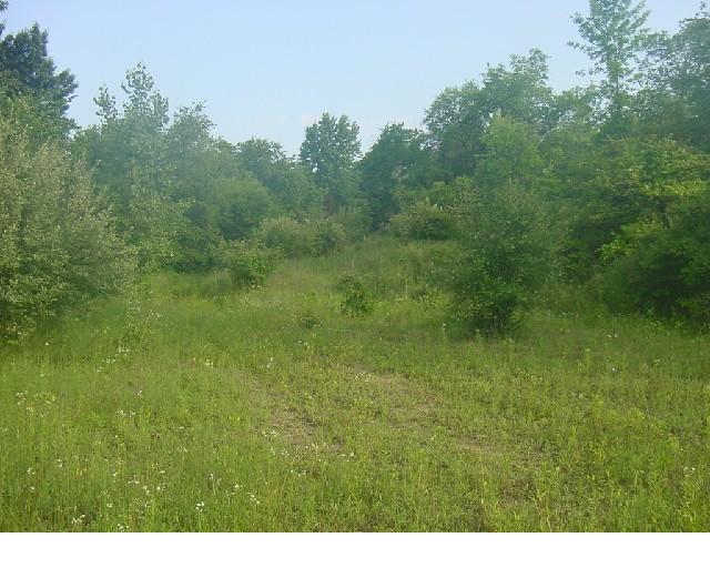
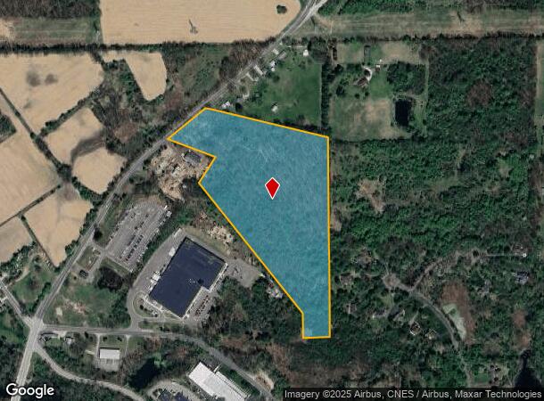
Property Record
4300 Mast Rd, Dexter, MI 48130
NEARBY LISTINGS FOR SALE OR LEASE
Property Detail
4300 Mast Rd
03-32-300-012
REWRITE PER SURVEY 12/05/2003 WE 32-17C PCL 4 COM AT S 1/4 COR SEC 32
Industrialacreage
Washtenaw
X
Michigan
26161C0230E
18.53 AC
2025
Washtenaw W of 23
2025
Detroit
461000
Ann Arbor, MI
DEMOGRAPHICS near 4300 Mast Rd
1 Mile
3 Mile
5 Mile
2024 Total Population
3,069
11,112
25,780
2029 Population
3,062
11,004
25,497
Pop Growth 2024-2029
(0.23%)
(0.97%)
(1.10%)
Average Age
41
42
42
2024 Total Households
1,194
4,169
9,670
HH Growth 2024-2029
(0.34%)
(1.08%)
(1.18%)
Median Household Inc
$98,768
$117,603
$120,004
Avg Household Size
2.50
2.60
2.60
2024 Avg HH Vehicles
2.00
2.00
2.00
Median Home Value
$390,403
$412,957
$424,846
Median Year Built
1993
1991
1991
Nearby Places
Map Layers
Map Styles
 Street
 Aerial
- Restaurants
- Banks
- Shops
- Fitness
- Groceries
PUBLIC TRANSPORTATION
AIRPORT
Detroit Metro Wayne County
DRIVE
WALK
Distance
Detroit Metro Wayne County
47 min
36.6 mi
Freight Ports
Port of Toledo
DRIVE
WALK
Distance
Port of Toledo
90 min
69.8 mi
SALE & LEASE HISTORY
LISTING DATE
SALE/LEASE

Sep 24, 2016
For Sale
Nearby Properties
Address
Land Use
TOTAL SIZE
Lot Size
Zoning
Address
Land Use
TOTAL SIZE
Lot Size
Zoning
460,082 SF
42.24 AC
RD
Address
Land Use
TOTAL SIZE
Lot Size
Zoning
443,838 SF
47.01 AC
I-1
Address
Land Use
TOTAL SIZE
Lot Size
Zoning
24.06 AC
R-3
Address
Land Use
TOTAL SIZE
Lot Size
Zoning
61,760 SF
18.06 AC
II
Address
Land Use
TOTAL SIZE
Lot Size
Zoning
52,990 SF
20.49 AC
I-1
Address
Land Use
TOTAL SIZE
Lot Size
Zoning
Address
Land Use
TOTAL SIZE
Lot Size
Zoning
13.36 AC
R-3
Address
Land Use
TOTAL SIZE
Lot Size
Zoning
Address
Land Use
TOTAL SIZE
Lot Size
Zoning
49,707 SF
4.50 AC
C-1
Address
Land Use
TOTAL SIZE
Lot Size
Zoning
31,970 SF
8.34 AC
C-1
Address
Land Use
TOTAL SIZE
Lot Size
Zoning
88,590 SF
9.80 AC
RD
Address
Land Use
TOTAL SIZE
Lot Size
Zoning
150,000 SF
18.24 AC
I-1
Address
Land Use
TOTAL SIZE
Lot Size
Zoning
68,000 SF
11.61 AC
RD
Address
Land Use
TOTAL SIZE
Lot Size
Zoning
84,460 SF
IFT PARCEL
Address
Land Use
TOTAL SIZE
Lot Size
Zoning
67,262 SF
9.05 AC
C-1
Address
Land Use
TOTAL SIZE
Lot Size
Zoning
4,788 SF
14.35 AC
SEVERAL
Address
Land Use
TOTAL SIZE
Lot Size
Zoning
43,293 SF
2.20 AC
RD
Address
Land Use
TOTAL SIZE
Lot Size
Zoning
15,444 SF
3.28 AC
PB
Address
Land Use
TOTAL SIZE
Lot Size
Zoning
576 SF
IFT PARCEL
Address
Land Use
TOTAL SIZE
Lot Size
Zoning
21,870 SF
0.46 AC
VILLAGE
Address
Land Use
TOTAL SIZE
Lot Size
Zoning
10,530 SF
2 AC
PB
Address
Land Use
TOTAL SIZE
Lot Size
Zoning
73,803 SF
3.70 AC
RD
Address
Land Use
TOTAL SIZE
Lot Size
Zoning
7,890 SF
1.20 AC
VR
Address
Land Use
TOTAL SIZE
Lot Size
Zoning
21,312 SF
1.99 AC
PUD
Address
Land Use
TOTAL SIZE
Lot Size
Zoning
131,520 SF
6.62 AC
C-1
Address
Land Use
TOTAL SIZE
Lot Size
Zoning
62,900 SF
10.01 AC
RD
Address
Land Use
TOTAL SIZE
Lot Size
Zoning
57,836 SF
6.89 AC
VILLAGE
Address
Land Use
TOTAL SIZE
Lot Size
Zoning
61,128 SF
4.79 AC
VILLAGE
Address
Land Use
TOTAL SIZE
Lot Size
Zoning
4,721 SF
1.52 AC
PUD
Address
Land Use
TOTAL SIZE
Lot Size
Zoning
30,720 SF
3.50 AC
RD
The World's #1 Commercial Real Estate Marketplace
Connect with us
© 2025 CoStar Group
The information above has been obtained from sources believed reliable. While we do not doubt its accuracy we have not verified it and make no guarantee, warranty or representation about it. It is your responsibility to independently confirm its accuracy and completeness. Any projections, opinions, assumptions, or estimates used are for example only and do not represent the current or future performance of the property. The value of this transaction to you depends on tax and other factors which should be evaluated by your tax, financial, and legal advisors. You and your advisors should conduct a careful, independent investigation of the property to determine to your satisfaction the suitability of the property for your needs.