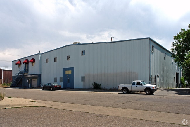
Property Record
4300 Adams St, Denver, CO 80216

This Property Is For Sale
NEARBY LISTINGS FOR SALE OR LEASE
Property Detail
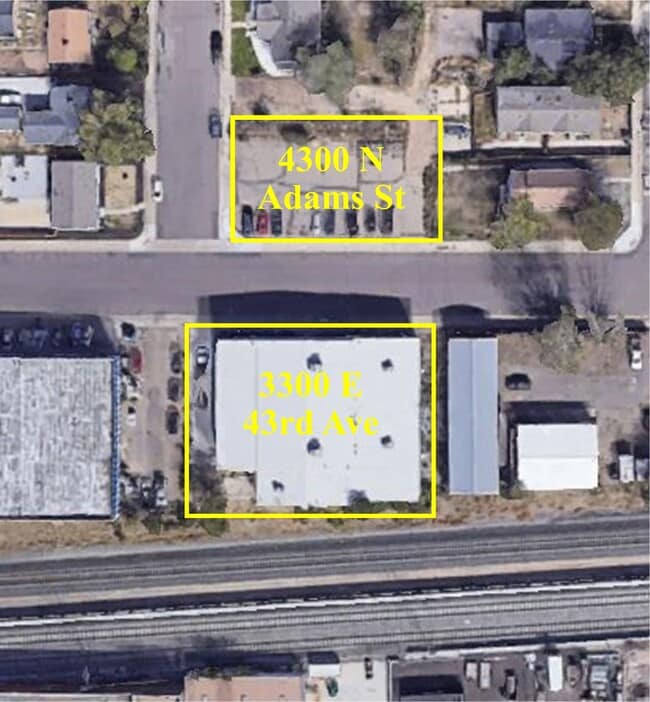
4300 Adams St
Denver-Aurora-Lakewood, CO
Town Of Swansea
2241-23-011
PORTION LOT5
Commercialnec
Denver
X
Colorado
08005C0025K
1
2024
0.22 AC
2024
Lower North Central
003501
Denver
9,375 SF
DEMOGRAPHICS near 4300 Adams St
1 Mile
3 Mile
5 Mile
2024 Total Population
11,131
128,360
403,149
2029 Population
11,195
130,372
411,683
Pop Growth 2024-2029
+ 0.57%
+ 1.57%
+ 2.12%
Average Age
35
37
37
2024 Total Households
3,809
61,065
188,196
HH Growth 2024-2029
+ 0.37%
+ 1.59%
+ 2.06%
Median Household Inc
$64,401
$82,737
$87,446
Avg Household Size
2.70
2.00
2.00
2024 Avg HH Vehicles
2.00
1.00
1.00
Median Home Value
$410,112
$624,186
$648,997
Median Year Built
1953
1966
1972
Nearby Places
Map Layers
Map Styles
 Street
 Aerial
- Restaurants
- Banks
- Shops
- Fitness
- Groceries
PUBLIC TRANSPORTATION
COMMUTER RAIL
DRIVE
WALK
Distance
2 min
12 min
0.5 mi
DRIVE
WALK
Distance
2 min
13 min
0.6 mi
AIRPORT
Denver International
DRIVE
WALK
Distance
Denver International
27 min
20.2 mi
Nearby Properties
Address
Land Use
TOTAL SIZE
Lot Size
Zoning
Address
Land Use
TOTAL SIZE
Lot Size
Zoning
396,741 SF
8.12 AC
A1
Address
Land Use
TOTAL SIZE
Lot Size
Zoning
857,233 SF
10.26 AC
CMP-H
Address
Land Use
TOTAL SIZE
Lot Size
Zoning
1,567,575 SF
1.40 AC
D-C
Address
Land Use
TOTAL SIZE
Lot Size
Zoning
724,981 SF
1.26 AC
D-C
Address
Land Use
TOTAL SIZE
Lot Size
Zoning
1,018,386 SF
2.46 AC
D-C
Address
Land Use
TOTAL SIZE
Lot Size
Zoning
888,385 SF
20.40 AC
I-A
Address
Land Use
TOTAL SIZE
Lot Size
Zoning
719,357 SF
21.47 AC
M-MX-5
Address
Land Use
TOTAL SIZE
Lot Size
Zoning
934,630 SF
10.93 AC
H-1-A
Address
Land Use
TOTAL SIZE
Lot Size
Zoning
793,250 SF
0.83 AC
D-C
Address
Land Use
TOTAL SIZE
Lot Size
Zoning
281,209 SF
1.66 AC
C-MX-12
Address
Land Use
TOTAL SIZE
Lot Size
Zoning
579,102 SF
7.47 AC
H-1-A
Address
Land Use
TOTAL SIZE
Lot Size
Zoning
635,895 SF
2.45 AC
D-C
Address
Land Use
TOTAL SIZE
Lot Size
Zoning
222,000 SF
2.98 AC
PUD-G
Address
Land Use
TOTAL SIZE
Lot Size
Zoning
25,000 SF
40.42 AC
I-A
Address
Land Use
TOTAL SIZE
Lot Size
Zoning
3,188 SF
81.17 AC
I-B
Address
Land Use
TOTAL SIZE
Lot Size
Zoning
230,246 SF
0.79 AC
I-MX-8
Address
Land Use
TOTAL SIZE
Lot Size
Zoning
237,753 SF
18.94 AC
U-SU-B1
Address
Land Use
TOTAL SIZE
Lot Size
Zoning
293,490 SF
2.45 AC
D-C
Address
Land Use
TOTAL SIZE
Lot Size
Zoning
233,863 SF
1.12 AC
D-C
Address
Land Use
TOTAL SIZE
Lot Size
Zoning
254,509 SF
16.29 AC
E-SU-DX
Address
Land Use
TOTAL SIZE
Lot Size
Zoning
238,888 SF
1.13 AC
C-MX-12
Address
Land Use
TOTAL SIZE
Lot Size
Zoning
177,366 SF
3.85 AC
C-MX-8
Address
Land Use
TOTAL SIZE
Lot Size
Zoning
342,829 SF
0.65 AC
D-C
Address
Land Use
TOTAL SIZE
Lot Size
Zoning
307,826 SF
1.55 AC
PUD
Address
Land Use
TOTAL SIZE
Lot Size
Zoning
551,915 SF
25.76 AC
Address
Land Use
TOTAL SIZE
Lot Size
Zoning
201,798 SF
0.71 AC
I-MX-5
Address
Land Use
TOTAL SIZE
Lot Size
Zoning
359,819 SF
7.23 AC
CMP-H
Address
Land Use
TOTAL SIZE
Lot Size
Zoning
599,680 SF
43.94 AC
Address
Land Use
TOTAL SIZE
Lot Size
Zoning
477,508 SF
79.66 AC
OS-A
Address
Land Use
TOTAL SIZE
Lot Size
Zoning
172,690 SF
0.62 AC
C-MX-12
The World's #1 Commercial Real Estate Marketplace
Connect with us
© 2025 CoStar Group
The information above has been obtained from sources believed reliable. While we do not doubt its accuracy we have not verified it and make no guarantee, warranty or representation about it. It is your responsibility to independently confirm its accuracy and completeness. Any projections, opinions, assumptions, or estimates used are for example only and do not represent the current or future performance of the property. The value of this transaction to you depends on tax and other factors which should be evaluated by your tax, financial, and legal advisors. You and your advisors should conduct a careful, independent investigation of the property to determine to your satisfaction the suitability of the property for your needs.