Property Record
4309 Gadsden St, Birmingham, AL 35217
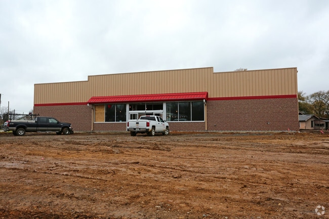

This Property Is For Sale
Current Lease Availabilities
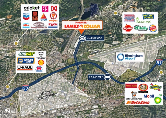
NEARBY LISTINGS FOR SALE OR LEASE
Property Detail
4309 Gadsden St
Birmingham-Hoover, AL
Family Dollar 2Nd Res Of Benda
23-00-07-4-031-005.000
LOT 1C FAMILY DOLLAR 2ND RESURVEY OF BENDALE PB 240 PG 97
Storebuilding
Jefferson
X
Alabama
01073C0383H
1c
2023
1.46 AC
2024
Fultondale
011904
Birmingham
8,505 SF
DEMOGRAPHICS near 4309 Gadsden St
1 Mile
3 Mile
5 Mile
2024 Total Population
5,645
35,825
119,228
2029 Population
5,735
36,183
119,022
Pop Growth 2024-2029
+ 1.59%
+ 1.00%
(0.17%)
Average Age
38
39
39
2024 Total Households
2,177
14,382
51,648
HH Growth 2024-2029
+ 1.52%
+ 1.06%
(0.17%)
Median Household Inc
$36,601
$31,116
$43,544
Avg Household Size
2.40
2.30
2.10
2024 Avg HH Vehicles
1.00
1.00
1.00
Median Home Value
$54,177
$85,708
$168,066
Median Year Built
1962
1963
1965
Nearby Places
Map Layers
Map Styles
 Street
 Aerial
- Restaurants
- Banks
- Shops
- Fitness
- Groceries
PUBLIC TRANSPORTATION
COMMUTER RAIL
Birmingham (Crescent - Amtrak)
DRIVE
WALK
Distance
Birmingham (Crescent - Amtrak)
8 min
4.9 mi
AIRPORT
Birmingham-Shuttlesworth International
DRIVE
WALK
Distance
Birmingham-Shuttlesworth International
7 min
4.3 mi
Freight Ports
Port of Mobile
DRIVE
WALK
Distance
Port of Mobile
286 min
260.8 mi
Nearby Properties
Address
Land Use
TOTAL SIZE
Lot Size
Zoning
Address
Land Use
TOTAL SIZE
Lot Size
Zoning
145,865 SF
142 AC
M1-M
Address
Land Use
TOTAL SIZE
Lot Size
Zoning
298,966 SF
73 AC
M1
Address
Land Use
TOTAL SIZE
Lot Size
Zoning
237,826 SF
12 AC
B3
Address
Land Use
TOTAL SIZE
Lot Size
Zoning
216,610 SF
20 AC
R3
Address
Land Use
TOTAL SIZE
Lot Size
Zoning
225,000 SF
14 AC
B-2
Address
Land Use
TOTAL SIZE
Lot Size
Zoning
345,035 SF
39 AC
M1
Address
Land Use
TOTAL SIZE
Lot Size
Zoning
456,619 SF
27.30 AC
M2
Address
Land Use
TOTAL SIZE
Lot Size
Zoning
222,082 SF
46 AC
R3
Address
Land Use
TOTAL SIZE
Lot Size
Zoning
113,147 SF
115 AC
M1
Address
Land Use
TOTAL SIZE
Lot Size
Zoning
108,813 SF
156 AC
M-1
Address
Land Use
TOTAL SIZE
Lot Size
Zoning
124,896 SF
11 AC
R1-B
Address
Land Use
TOTAL SIZE
Lot Size
Zoning
29,095 SF
2.64 AC
B2
Address
Land Use
TOTAL SIZE
Lot Size
Zoning
209,613 SF
4 AC
M1
Address
Land Use
TOTAL SIZE
Lot Size
Zoning
366,807 SF
25.30 AC
M2
Address
Land Use
TOTAL SIZE
Lot Size
Zoning
134,840 SF
7.80 AC
C1
Address
Land Use
TOTAL SIZE
Lot Size
Zoning
42,821 SF
10.10 AC
B2
Address
Land Use
TOTAL SIZE
Lot Size
Zoning
195,573 SF
12 AC
M2
Address
Land Use
TOTAL SIZE
Lot Size
Zoning
60,832 SF
162 AC
M1
Address
Land Use
TOTAL SIZE
Lot Size
Zoning
148,165 SF
15.65 AC
M1
Address
Land Use
TOTAL SIZE
Lot Size
Zoning
212,486 SF
9 AC
M1
Address
Land Use
TOTAL SIZE
Lot Size
Zoning
29,614 SF
1.63 AC
B2
Address
Land Use
TOTAL SIZE
Lot Size
Zoning
83,432 SF
5.50 AC
R1-B
Address
Land Use
TOTAL SIZE
Lot Size
Zoning
126,976 SF
25 AC
M1
Address
Land Use
TOTAL SIZE
Lot Size
Zoning
74,984 SF
1.25 AC
R5
Address
Land Use
TOTAL SIZE
Lot Size
Zoning
138,649 SF
7.75 AC
M1
Address
Land Use
TOTAL SIZE
Lot Size
Zoning
58,718 SF
5.99 AC
M1
Address
Land Use
TOTAL SIZE
Lot Size
Zoning
229,670 SF
12 AC
CM2
Address
Land Use
TOTAL SIZE
Lot Size
Zoning
239,755 SF
17 AC
M2
Address
Land Use
TOTAL SIZE
Lot Size
Zoning
13,072 SF
20.10 AC
M2
Address
Land Use
TOTAL SIZE
Lot Size
Zoning
225,124 SF
15 AC
M2
The World's #1 Commercial Real Estate Marketplace
Connect with us
© 2026 CoStar Group
The information above has been obtained from sources believed reliable. While we do not doubt its accuracy we have not verified it and make no guarantee, warranty or representation about it. It is your responsibility to independently confirm its accuracy and completeness. Any projections, opinions, assumptions, or estimates used are for example only and do not represent the current or future performance of the property. The value of this transaction to you depends on tax and other factors which should be evaluated by your tax, financial, and legal advisors. You and your advisors should conduct a careful, independent investigation of the property to determine to your satisfaction the suitability of the property for your needs.