Property Record
4300 W Interstate 20, Midland, TX 79703
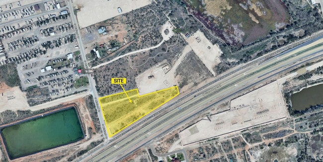

This Property Is For Sale
Property Detail
4300 W Interstate 20
Midland, TX
ACRES: 5.810 SW/4 SEC: 5 BLK: 39-T2S
R000004-606
MIDLAND
Realpropertynec
Texas
BP
5.81 AC
2025
Midland & Odessa
2025
Other Market Areas
001200
NEARBY LISTINGS FOR SALE OR LEASE
DEMOGRAPHICS near 4300 W Interstate 20
1 mile
3 mile
5 mile
2024 Total Population
1,753
35,393
102,527
2029 Population
1,749
36,051
105,061
Pop Growth 2024-2029
(0.23%)
+ 1.86%
+ 2.47%
Average Age
33
34
35
2024 Total Households
537
12,207
36,811
HH Growth 2024-2029
0.00%
+ 2.23%
+ 2.82%
Median Household Inc
$84,722
$72,524
$75,600
Avg Household Size
3.00
2.80
2.70
2024 Avg HH Vehicles
2.00
2.00
2.00
Median Home Value
$219,132
$204,928
$257,186
Median Year Built
1980
1975
1981
Nearby Places
Map Layers
Map Styles
 Street
 Aerial
Transit
 Traffic
 Biking
Places
Listings with unknown addresses are not visible on the map
- Restaurants
- Banks
- Shops
- Fitness
- Groceries
PUBLIC TRANSPORTATION
AIRPORT
Midland International Air And Space Port
Drive
Walk
Distance
Midland International Air And Space Port
14 min
8.6 mi
Nearby Properties
Address
Land Use
TOTAL SIZE
Lot Size
Zoning
Address
Land Use
TOTAL SIZE
Lot Size
Zoning
2,453 SF
13.68 AC
Address
Land Use
TOTAL SIZE
Lot Size
Zoning
28,750 SF
10.11 AC
Address
Land Use
TOTAL SIZE
Lot Size
Zoning
Address
Land Use
TOTAL SIZE
Lot Size
Zoning
44,784 SF
11.97 AC
MF1
Address
Land Use
TOTAL SIZE
Lot Size
Zoning
6,864 SF
10.35 AC
Address
Land Use
TOTAL SIZE
Lot Size
Zoning
209,680 SF
6.16 AC
Address
Land Use
TOTAL SIZE
Lot Size
Zoning
1,618 SF
4.18 AC
Address
Land Use
TOTAL SIZE
Lot Size
Zoning
137,457 SF
8.73 AC
MF1
Address
Land Use
TOTAL SIZE
Lot Size
Zoning
86,922 SF
1.87 AC
PDMC
Address
Land Use
TOTAL SIZE
Lot Size
Zoning
12,420 SF
40.94 AC
Address
Land Use
TOTAL SIZE
Lot Size
Zoning
55,790 SF
2.54 AC
PDSC
Address
Land Use
TOTAL SIZE
Lot Size
Zoning
11,716 SF
1.49 AC
Address
Land Use
TOTAL SIZE
Lot Size
Zoning
3,399 SF
648 AC
Address
Land Use
TOTAL SIZE
Lot Size
Zoning
105,182 SF
5.29 AC
MF1
Address
Land Use
TOTAL SIZE
Lot Size
Zoning
15,068 SF
2.77 AC
LR2
Address
Land Use
TOTAL SIZE
Lot Size
Zoning
720 SF
1.86 AC
Address
Land Use
TOTAL SIZE
Lot Size
Zoning
103,600 SF
2.94 AC
Address
Land Use
TOTAL SIZE
Lot Size
Zoning
11,536 SF
1.60 AC
Address
Land Use
TOTAL SIZE
Lot Size
Zoning
70,000 SF
4.42 AC
PDOC
Address
Land Use
TOTAL SIZE
Lot Size
Zoning
17,022 SF
1.60 AC
Address
Land Use
TOTAL SIZE
Lot Size
Zoning
14,472 SF
2.50 AC
Address
Land Use
TOTAL SIZE
Lot Size
Zoning
31,260 SF
5.83 AC
MF1
Address
Land Use
TOTAL SIZE
Lot Size
Zoning
176,902 SF
5.04 AC
LR2
Address
Land Use
TOTAL SIZE
Lot Size
Zoning
300,000 SF
20.01 AC
Address
Land Use
TOTAL SIZE
Lot Size
Zoning
7,697 SF
3.51 AC
PDSC
Address
Land Use
TOTAL SIZE
Lot Size
Zoning
3,300 SF
18.80 AC
LR2
Address
Land Use
TOTAL SIZE
Lot Size
Zoning
26,090 SF
3.27 AC
Address
Land Use
TOTAL SIZE
Lot Size
Zoning
15,838 SF
2 AC
PDSC
Address
Land Use
TOTAL SIZE
Lot Size
Zoning
28,593 SF
23.92 AC
PDMC
Address
Land Use
TOTAL SIZE
Lot Size
Zoning
27,025 SF
3.24 AC
The World's #1 Commercial Real Estate Marketplace
Connect with us
© 2026 CoStar Group
The information above has been obtained from sources believed reliable. While we do not doubt its accuracy we have not verified it and make no guarantee, warranty or representation about it. It is your responsibility to independently confirm its accuracy and completeness. Any projections, opinions, assumptions, or estimates used are for example only and do not represent the current or future performance of the property. The value of this transaction to you depends on tax and other factors which should be evaluated by your tax, financial, and legal advisors. You and your advisors should conduct a careful, independent investigation of the property to determine to your satisfaction the suitability of the property for your needs.