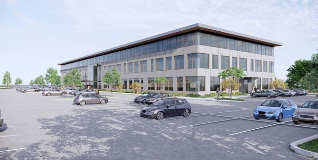
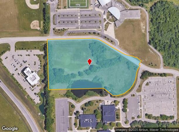
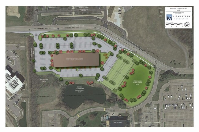
Property Record
4300 Whitehall Dr, Ann Arbor, MI 48105
Current Lease Availabilities
NEARBY LISTINGS FOR SALE OR LEASE
Property Detail
4300 Whitehall Dr
09-13-200-021
REWRITE PER MLC L5187 P653 OWNER REQUEST ****FROM 0913100011 05/28/97****FROM 0913200012 05/28/97****FROM 0913200013 05/28/97
Commercialacreage
Washtenaw
X
Michigan
26161C0258E
9.29 AC
2025
Washtenaw E of 23
2025
Detroit
406000
Ann Arbor, MI
DEMOGRAPHICS near 4300 Whitehall Dr
1 Mile
3 Mile
5 Mile
2024 Total Population
1,988
32,540
114,695
2029 Population
1,971
32,328
113,468
Pop Growth 2024-2029
(0.86%)
(0.65%)
(1.07%)
Average Age
42
37
35
2024 Total Households
889
12,814
46,284
HH Growth 2024-2029
(0.90%)
(0.57%)
(1.01%)
Median Household Inc
$94,621
$85,264
$67,223
Avg Household Size
2.20
2.20
2.10
2024 Avg HH Vehicles
2.00
2.00
1.00
Median Home Value
$331,250
$447,501
$433,040
Median Year Built
1978
1983
1973
Nearby Places
Map Layers
Map Styles
 Street
 Aerial
- Restaurants
- Banks
- Shops
- Fitness
- Groceries
PUBLIC TRANSPORTATION
COMMUTER RAIL
Ann Arbor Amtrak Station (Wolverine - Amtrak)
DRIVE
WALK
Distance
Ann Arbor Amtrak Station (Wolverine - Amtrak)
10 min
7.1 mi
AIRPORT
Detroit Metro Wayne County
DRIVE
WALK
Distance
Detroit Metro Wayne County
35 min
27.6 mi
Freight Ports
Port of Toledo
DRIVE
WALK
Distance
Port of Toledo
77 min
60.6 mi
Nearby Properties
Address
Land Use
TOTAL SIZE
Lot Size
Zoning
Address
Land Use
TOTAL SIZE
Lot Size
Zoning
358,683 SF
5.42 AC
PUD
Address
Land Use
TOTAL SIZE
Lot Size
Zoning
2,668 SF
31.60 AC
PUD
Address
Land Use
TOTAL SIZE
Lot Size
Zoning
524,946 SF
10.43 AC
PUD
Address
Land Use
TOTAL SIZE
Lot Size
Zoning
301,086 SF
21.41 AC
R4A
Address
Land Use
TOTAL SIZE
Lot Size
Zoning
324,832 SF
18.81 AC
R4A
Address
Land Use
TOTAL SIZE
Lot Size
Zoning
273,440 SF
73.06 AC
RRA
Address
Land Use
TOTAL SIZE
Lot Size
Zoning
208,890 SF
A-1
Address
Land Use
TOTAL SIZE
Lot Size
Zoning
219,322 SF
19.82 AC
R4D
Address
Land Use
TOTAL SIZE
Lot Size
Zoning
114,208 SF
8.63 AC
PUD
Address
Land Use
TOTAL SIZE
Lot Size
Zoning
202,219 SF
22.84 AC
PUD
Address
Land Use
TOTAL SIZE
Lot Size
Zoning
5,416 SF
30.14 AC
R-9
Address
Land Use
TOTAL SIZE
Lot Size
Zoning
919,507 SF
17.53 AC
OP
Address
Land Use
TOTAL SIZE
Lot Size
Zoning
919,507 SF
20.95 AC
OP
Address
Land Use
TOTAL SIZE
Lot Size
Zoning
340,425 SF
31.50 AC
R4B
Address
Land Use
TOTAL SIZE
Lot Size
Zoning
919,507 SF
15.40 AC
RC
Address
Land Use
TOTAL SIZE
Lot Size
Zoning
919,507 SF
16.06 AC
OP
Address
Land Use
TOTAL SIZE
Lot Size
Zoning
163,812 SF
6.96 AC
R4D
Address
Land Use
TOTAL SIZE
Lot Size
Zoning
192,963 SF
21.19 AC
R4A
Address
Land Use
TOTAL SIZE
Lot Size
Zoning
222,022 SF
11.21 AC
R4A
Address
Land Use
TOTAL SIZE
Lot Size
Zoning
110,389 SF
16.04 AC
RRA
Address
Land Use
TOTAL SIZE
Lot Size
Zoning
147,200 SF
16.58 AC
RE
Address
Land Use
TOTAL SIZE
Lot Size
Zoning
166,092 SF
12.63 AC
R4A
Address
Land Use
TOTAL SIZE
Lot Size
Zoning
128,525 SF
12.36 AC
C3
Address
Land Use
TOTAL SIZE
Lot Size
Zoning
79,500 SF
8.82 AC
PUD
Address
Land Use
TOTAL SIZE
Lot Size
Zoning
90,546 SF
12.57 AC
ORL
Address
Land Use
TOTAL SIZE
Lot Size
Zoning
147,696 SF
11.71 AC
R4A
Address
Land Use
TOTAL SIZE
Lot Size
Zoning
128,920 SF
10.10 AC
R4B
Address
Land Use
TOTAL SIZE
Lot Size
Zoning
57,800 SF
4.65 AC
R4D
Address
Land Use
TOTAL SIZE
Lot Size
Zoning
138,340 SF
9.33 AC
C3
Address
Land Use
TOTAL SIZE
Lot Size
Zoning
The World's #1 Commercial Real Estate Marketplace
Connect with us
© 2026 CoStar Group
The information above has been obtained from sources believed reliable. While we do not doubt its accuracy we have not verified it and make no guarantee, warranty or representation about it. It is your responsibility to independently confirm its accuracy and completeness. Any projections, opinions, assumptions, or estimates used are for example only and do not represent the current or future performance of the property. The value of this transaction to you depends on tax and other factors which should be evaluated by your tax, financial, and legal advisors. You and your advisors should conduct a careful, independent investigation of the property to determine to your satisfaction the suitability of the property for your needs.