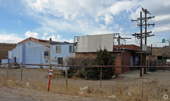
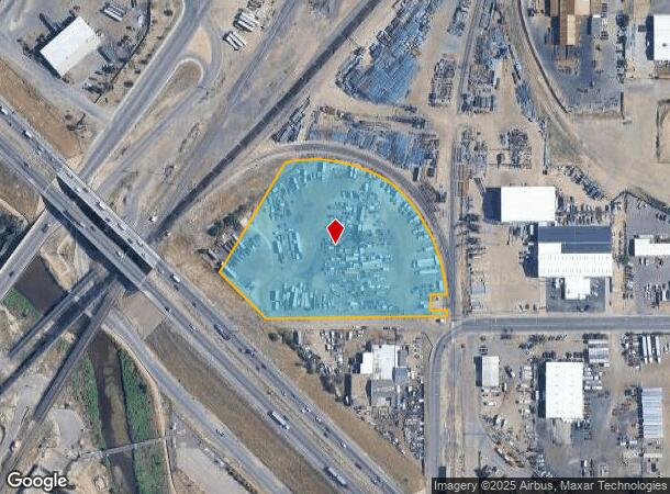
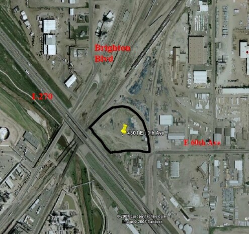
Property Record
4301 E 60Th Ave, Commerce City, CO 80022

Property Detail
4301 E 60Th Ave
Denver-Aurora-Centennial, CO
Commerce City Comm
1823-07-2-00-070
SECT,TWN,RNG:7-3-67 DESC: PARC IN NW4 SEC 7 DESC AS FOLS BEG AT SW COR SD NW4 TH E 281/20 FT TO THE POB TH N 45D 45M W ALG NELY ROW LN OF I-270 220/64 FT TO A LN 200 FT SELY OF C/L OF THE MAIN TRACK OF THE DENVER TO CHEYENNE MAIN LN OF U P RR CO TH N
Commercialacreage
Adams
X
Colorado
0800460087H
4.64 AC
2024
Northeast Denver
2025
Denver
988700
NEARBY LISTINGS FOR SALE OR LEASE
DEMOGRAPHICS near 4301 E 60Th Ave
1 mile
3 mile
5 mile
2024 Total Population
2,606
53,157
297,452
2029 Population
2,677
54,188
304,490
Pop Growth 2024-2029
+ 2.72%
+ 1.94%
+ 2.37%
Average Age
36
35
36
2024 Total Households
799
17,253
123,261
HH Growth 2024-2029
+ 2.50%
+ 1.78%
+ 2.25%
Median Household Inc
$66,994
$62,193
$82,736
Avg Household Size
3.10
2.90
2.30
2024 Avg HH Vehicles
2.00
2.00
2.00
Median Home Value
$320,569
$354,343
$486,738
Median Year Built
1958
1960
1975
Nearby Places
Map Layers
Map Styles
 Street
 Aerial
Transit
 Traffic
 Biking
Places
Listings with unknown addresses are not visible on the map
- Restaurants
- Banks
- Shops
- Fitness
- Groceries
PUBLIC TRANSPORTATION
COMMUTER RAIL
Commerce City - 72Nd Station Track 1 (Union Station to Eastlake & 124th Station - Regional Transportation District)
Drive
Walk
Distance
Commerce City - 72Nd Station Track 1 (Union Station to Eastlake & 124th Station - Regional Transportation District)
6 min
2.0 mi
40Th & Colorado Station Track 1 (Union Station to Denver Airport Station - Regional Transportation District)
Drive
Walk
Distance
40Th & Colorado Station Track 1 (Union Station to Denver Airport Station - Regional Transportation District)
6 min
3.0 mi
AIRPORT
Denver International
Drive
Walk
Distance
Denver International
28 min
20.8 mi
Freight Ports
Tulsa Port Of Catoosa
Drive
Walk
Distance
Tulsa Port Of Catoosa
725 min
706.3 mi
SALE & LEASE HISTORY
LISTING DATE
SALE/LEASE

Mar 29, 2023
For Lease
Feb 26, 2020
For Lease
Nearby Properties
Address
Land Use
TOTAL SIZE
Lot Size
Zoning
Address
Land Use
TOTAL SIZE
Lot Size
Zoning
396,741 SF
8.12 AC
A1
Address
Land Use
TOTAL SIZE
Lot Size
Zoning
1.64 AC
CMP
Address
Land Use
TOTAL SIZE
Lot Size
Zoning
256,155 SF
3.84 AC
Address
Land Use
TOTAL SIZE
Lot Size
Zoning
3,188 SF
81.17 AC
I-B
Address
Land Use
TOTAL SIZE
Lot Size
Zoning
140,328 SF
6.54 AC
PUD
Address
Land Use
TOTAL SIZE
Lot Size
Zoning
17,063 SF
2.01 AC
Address
Land Use
TOTAL SIZE
Lot Size
Zoning
649,540 SF
33.65 AC
Address
Land Use
TOTAL SIZE
Lot Size
Zoning
446,845 SF
10.43 AC
CMP-NWC-G
Address
Land Use
TOTAL SIZE
Lot Size
Zoning
134,729 SF
5.57 AC
Address
Land Use
TOTAL SIZE
Lot Size
Zoning
551,915 SF
25.76 AC
Address
Land Use
TOTAL SIZE
Lot Size
Zoning
599,680 SF
43.94 AC
Address
Land Use
TOTAL SIZE
Lot Size
Zoning
74,106 SF
3.95 AC
PUD
Address
Land Use
TOTAL SIZE
Lot Size
Zoning
595,017 SF
11.62 AC
I-B
Address
Land Use
TOTAL SIZE
Lot Size
Zoning
116,502 SF
4.08 AC
Address
Land Use
TOTAL SIZE
Lot Size
Zoning
344,689 SF
11.77 AC
I-B
Address
Land Use
TOTAL SIZE
Lot Size
Zoning
296,000 SF
52.44 AC
A3
Address
Land Use
TOTAL SIZE
Lot Size
Zoning
94,213 SF
3.84 AC
A1
Address
Land Use
TOTAL SIZE
Lot Size
Zoning
419,745 SF
24.75 AC
Address
Land Use
TOTAL SIZE
Lot Size
Zoning
146,217 SF
5.28 AC
I-MX-8
Address
Land Use
TOTAL SIZE
Lot Size
Zoning
340,000 SF
2.65 AC
C-MX-8
Address
Land Use
TOTAL SIZE
Lot Size
Zoning
439,200 SF
25.09 AC
Address
Land Use
TOTAL SIZE
Lot Size
Zoning
138,799 SF
16.28 AC
I-A
Address
Land Use
TOTAL SIZE
Lot Size
Zoning
90,760 SF
6.48 AC
Address
Land Use
TOTAL SIZE
Lot Size
Zoning
268,268 SF
29.99 AC
I-B
Address
Land Use
TOTAL SIZE
Lot Size
Zoning
177,366 SF
3.85 AC
C-MX-8
Address
Land Use
TOTAL SIZE
Lot Size
Zoning
341,009 SF
2.36 AC
I-MX-8
Address
Land Use
TOTAL SIZE
Lot Size
Zoning
6.69 AC
B-3
Address
Land Use
TOTAL SIZE
Lot Size
Zoning
293,784 SF
2.27 AC
I-MX-12
Address
Land Use
TOTAL SIZE
Lot Size
Zoning
179,691 SF
4.05 AC
I-MX-8
Address
Land Use
TOTAL SIZE
Lot Size
Zoning
194,976 SF
4.48 AC
I-MX-12
The World's #1 Commercial Real Estate Marketplace
Connect with us
© 2026 CoStar Group
The information above has been obtained from sources believed reliable. While we do not doubt its accuracy we have not verified it and make no guarantee, warranty or representation about it. It is your responsibility to independently confirm its accuracy and completeness. Any projections, opinions, assumptions, or estimates used are for example only and do not represent the current or future performance of the property. The value of this transaction to you depends on tax and other factors which should be evaluated by your tax, financial, and legal advisors. You and your advisors should conduct a careful, independent investigation of the property to determine to your satisfaction the suitability of the property for your needs.