Property Record
4301 E Day Mount Spokane Rd, Colbert, WA 99005
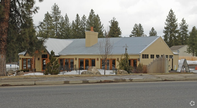

Property Detail
4301 E Day Mount Spokane Rd
37263.9025
26-27-43 W1/2 OF SW1/4 OF SW1/4 OF SW1/4 EXC RD
Storebuilding
Spokane
UR
Washington
B and X Area of moderate flood hazard, usually the area between the limits of the 100-year and 500-year floods.
4.46 AC
2025
NE North Metro
2025
Spokane
010203
Spokane-Spokane Valley, WA
4,348 SF
NEARBY LISTINGS FOR SALE OR LEASE
DEMOGRAPHICS near 4301 E Day Mount Spokane Rd
1 mile
3 mile
5 mile
2025 Total Population
4,116
20,636
39,541
2030 Population
4,116
20,977
40,216
Pop Growth 2025-2030
0.00%
+ 1.65%
+ 1.71%
Average Age
43
41
41
2025 Total Households
1,460
7,391
14,507
HH Growth 2025-2030
0.00%
+ 1.65%
+ 1.73%
Median Household Inc
$104,823
$97,362
$90,294
Avg Household Size
2.80
2.70
2.70
2025 Avg HH Vehicles
3.00
2.00
2.00
Median Home Value
$537,773
$489,765
$486,736
Median Year Built
1993
1995
1993
Nearby Places
Map Layers
Map Styles
 Street
 Aerial
Layers
 Traffic
 Biking
Places
Listings with unknown addresses are not visible on the map
- Restaurants
- Banks
- Shops
- Fitness
- Groceries
PUBLIC TRANSPORTATION
AIRPORT
Spokane International
Drive
Walk
Distance
Spokane International
34 min
17.9 mi
SALE & LEASE HISTORY
LISTING DATE
SALE/LEASE

Jun 03, 2020
For Sale
Aug 22, 2023
For Lease
Nearby Properties
Address
Land Use
TOTAL SIZE
Lot Size
Zoning
Address
Land Use
TOTAL SIZE
Lot Size
Zoning
157,654 SF
77.80 AC
RT
Address
Land Use
TOTAL SIZE
Lot Size
Zoning
215,573 SF
11.30 AC
HDR
Address
Land Use
TOTAL SIZE
Lot Size
Zoning
172,525 SF
8.18 AC
HDR
Address
Land Use
TOTAL SIZE
Lot Size
Zoning
166,390 SF
19.33 AC
MU
Address
Land Use
TOTAL SIZE
Lot Size
Zoning
142,776 SF
77.39 AC
UR
Address
Land Use
TOTAL SIZE
Lot Size
Zoning
121,519 SF
6.26 AC
HDR
Address
Land Use
TOTAL SIZE
Lot Size
Zoning
64,558 SF
11.91 AC
LDR
Address
Land Use
TOTAL SIZE
Lot Size
Zoning
317,432 SF
36.25 AC
LDR
Address
Land Use
TOTAL SIZE
Lot Size
Zoning
105,791 SF
22.82 AC
LDR
Address
Land Use
TOTAL SIZE
Lot Size
Zoning
138,563 SF
110.83 AC
RT
Address
Land Use
TOTAL SIZE
Lot Size
Zoning
67,763 SF
13.12 AC
LDR
Address
Land Use
TOTAL SIZE
Lot Size
Zoning
46,350 SF
38.98 AC
RCV
Address
Land Use
TOTAL SIZE
Lot Size
Zoning
51,613 SF
21.83 AC
RCV
Address
Land Use
TOTAL SIZE
Lot Size
Zoning
52,908 SF
12.11 AC
LI
Address
Land Use
TOTAL SIZE
Lot Size
Zoning
32,512 SF
8.55 AC
UR
Address
Land Use
TOTAL SIZE
Lot Size
Zoning
93,150 SF
9.82 AC
LI
Address
Land Use
TOTAL SIZE
Lot Size
Zoning
Address
Land Use
TOTAL SIZE
Lot Size
Zoning
16,421 SF
9.02 AC
LDAC
Address
Land Use
TOTAL SIZE
Lot Size
Zoning
55,254 SF
3.01 AC
LI
Address
Land Use
TOTAL SIZE
Lot Size
Zoning
40.02 AC
Address
Land Use
TOTAL SIZE
Lot Size
Zoning
55,278 SF
3.22 AC
LDAC
Address
Land Use
TOTAL SIZE
Lot Size
Zoning
19,400 SF
9.18 AC
LDAC
Address
Land Use
TOTAL SIZE
Lot Size
Zoning
48,621 SF
5.26 AC
RC
Address
Land Use
TOTAL SIZE
Lot Size
Zoning
8,300 SF
18.35 AC
LDR
Address
Land Use
TOTAL SIZE
Lot Size
Zoning
66,931 SF
13.03 AC
UR
Address
Land Use
TOTAL SIZE
Lot Size
Zoning
30.87 AC
Address
Land Use
TOTAL SIZE
Lot Size
Zoning
53,294 SF
4.71 AC
RAC
Address
Land Use
TOTAL SIZE
Lot Size
Zoning
20,060 SF
21.09 AC
HI
Address
Land Use
TOTAL SIZE
Lot Size
Zoning
8.24 AC
Address
Land Use
TOTAL SIZE
Lot Size
Zoning
41.15 AC
The World's #1 Commercial Real Estate Marketplace
Connect with us
© 2026 CoStar Group
The information above has been obtained from sources believed reliable. While we do not doubt its accuracy we have not verified it and make no guarantee, warranty or representation about it. It is your responsibility to independently confirm its accuracy and completeness. Any projections, opinions, assumptions, or estimates used are for example only and do not represent the current or future performance of the property. The value of this transaction to you depends on tax and other factors which should be evaluated by your tax, financial, and legal advisors. You and your advisors should conduct a careful, independent investigation of the property to determine to your satisfaction the suitability of the property for your needs.