Property Record
4301 E Maplewood Ave, Post Falls, ID 83854
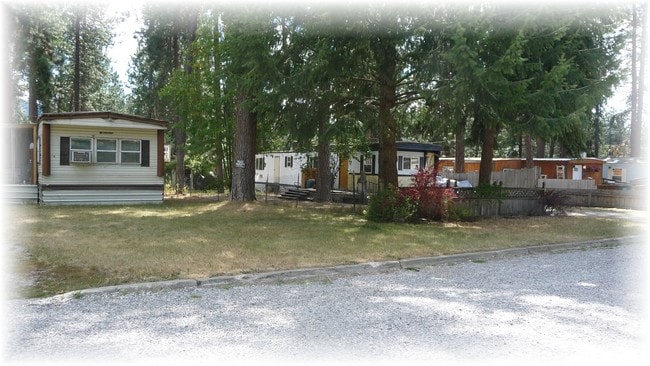
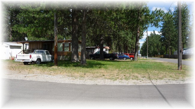
Property Detail
4301 E Maplewood Ave
0822000B004A
THOMPSON, TAX #21923 IN TRS 5 & 6, BLOCK B 0650N04W
Commercialnec
Kootenai
HDRES
Idaho
B and X Area of moderate flood hazard, usually the area between the limits of the 100-year and 500-year floods.
2.12 AC
2025
Kootenai County
2025
Other Market Areas
000601
Coeur d'Alene, ID
13,710 SF
NEARBY LISTINGS FOR SALE OR LEASE
-
-
View all Post Falls listings for sale on LoopNet.com
DEMOGRAPHICS near 4301 E Maplewood Ave
1 mile
3 mile
5 mile
2025 Total Population
6,766
38,561
87,724
2030 Population
7,140
40,641
92,253
Pop Growth 2025-2030
+ 5.53%
+ 5.39%
+ 5.16%
Average Age
42
40
40
2025 Total Households
2,651
14,903
34,179
HH Growth 2025-2030
+ 5.62%
+ 5.50%
+ 5.25%
Median Household Inc
$54,750
$66,839
$69,812
Avg Household Size
2.50
2.50
2.50
2025 Avg HH Vehicles
2.00
2.00
2.00
Median Home Value
$486,585
$489,507
$525,982
Median Year Built
1995
1998
2001
Nearby Places
Map Layers
Map Styles
 Street
 Aerial
Layers
 Traffic
 Biking
Places
Listings with unknown addresses are not visible on the map
- Restaurants
- Banks
- Shops
- Fitness
- Groceries
SALE & LEASE HISTORY
LISTING DATE
SALE/LEASE

Sep 29, 2016
For Sale
Nearby Properties
Address
Land Use
TOTAL SIZE
Lot Size
Zoning
Address
Land Use
TOTAL SIZE
Lot Size
Zoning
135,646 SF
18.40 AC
Address
Land Use
TOTAL SIZE
Lot Size
Zoning
117,842 SF
13.36 AC
AG
Address
Land Use
TOTAL SIZE
Lot Size
Zoning
32,132 SF
9.24 AC
Address
Land Use
TOTAL SIZE
Lot Size
Zoning
320,505 SF
60.51 AC
Address
Land Use
TOTAL SIZE
Lot Size
Zoning
89,184 SF
8.69 AC
Address
Land Use
TOTAL SIZE
Lot Size
Zoning
177,574 SF
8.44 AC
Address
Land Use
TOTAL SIZE
Lot Size
Zoning
88,780 SF
8.23 AC
Address
Land Use
TOTAL SIZE
Lot Size
Zoning
130,710 SF
8.23 AC
Address
Land Use
TOTAL SIZE
Lot Size
Zoning
57,936 SF
7.88 AC
Address
Land Use
TOTAL SIZE
Lot Size
Zoning
265,175 SF
13.74 AC
Address
Land Use
TOTAL SIZE
Lot Size
Zoning
116,728 SF
6.48 AC
Address
Land Use
TOTAL SIZE
Lot Size
Zoning
59,629 SF
5.37 AC
Address
Land Use
TOTAL SIZE
Lot Size
Zoning
110,520 SF
4.68 AC
Address
Land Use
TOTAL SIZE
Lot Size
Zoning
112,154 SF
4.61 AC
Address
Land Use
TOTAL SIZE
Lot Size
Zoning
91,220 SF
4.66 AC
Address
Land Use
TOTAL SIZE
Lot Size
Zoning
104,855 SF
4.71 AC
Address
Land Use
TOTAL SIZE
Lot Size
Zoning
118,990 SF
5.66 AC
Address
Land Use
TOTAL SIZE
Lot Size
Zoning
94,193 SF
18.10 AC
AGSUB
Address
Land Use
TOTAL SIZE
Lot Size
Zoning
192,335 SF
18.20 AC
Address
Land Use
TOTAL SIZE
Lot Size
Zoning
57,936 SF
5.28 AC
Address
Land Use
TOTAL SIZE
Lot Size
Zoning
59,912 SF
10.06 AC
COM
Address
Land Use
TOTAL SIZE
Lot Size
Zoning
106,656 SF
4.60 AC
Address
Land Use
TOTAL SIZE
Lot Size
Zoning
63,432 SF
7.29 AC
Address
Land Use
TOTAL SIZE
Lot Size
Zoning
108,524 SF
20.34 AC
Address
Land Use
TOTAL SIZE
Lot Size
Zoning
24,698 SF
44.94 AC
Address
Land Use
TOTAL SIZE
Lot Size
Zoning
16,185 SF
60.19 AC
Address
Land Use
TOTAL SIZE
Lot Size
Zoning
59,039 SF
4.17 AC
Address
Land Use
TOTAL SIZE
Lot Size
Zoning
56,150 SF
1.56 AC
Address
Land Use
TOTAL SIZE
Lot Size
Zoning
61,536 SF
4.40 AC
Address
Land Use
TOTAL SIZE
Lot Size
Zoning
73,776 SF
3.12 AC
The World's #1 Commercial Real Estate Marketplace
Connect with us
© 2026 CoStar Group
The information above has been obtained from sources believed reliable. While we do not doubt its accuracy we have not verified it and make no guarantee, warranty or representation about it. It is your responsibility to independently confirm its accuracy and completeness. Any projections, opinions, assumptions, or estimates used are for example only and do not represent the current or future performance of the property. The value of this transaction to you depends on tax and other factors which should be evaluated by your tax, financial, and legal advisors. You and your advisors should conduct a careful, independent investigation of the property to determine to your satisfaction the suitability of the property for your needs.