Property Record
4301 Nw Mattox Rd, Riverside, MO 64150
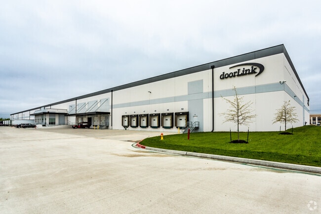
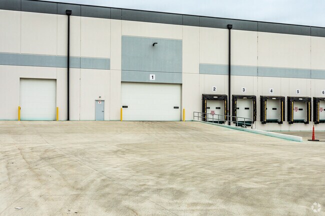
Property Detail
4301 Nw Mattox Rd
Kansas City, MO-KS
ARGO INNOVATION PARK 3RD TRACT A
23-30-06-000-000-113-000
Platte
Warehouse
Missouri
0
2
2025
20.10 AC
030101
Riverside/Parkville
480,000 SF
Kansas City
NEARBY LISTINGS FOR SALE OR LEASE
DEMOGRAPHICS near 4301 Nw Mattox Rd
1 mile
3 mile
5 mile
2025 Total Population
1,668
37,078
156,933
2030 Population
1,749
38,664
161,890
Pop Growth 2025-2030
+ 4.86%
+ 4.28%
+ 3.16%
Average Age
42
39
38
2025 Total Households
612
15,053
61,285
HH Growth 2025-2030
+ 4.90%
+ 4.40%
+ 3.33%
Median Household Inc
$138,380
$78,373
$67,276
Avg Household Size
2.70
2.40
2.40
2025 Avg HH Vehicles
2.00
2.00
2.00
Median Home Value
$395,871
$289,355
$227,290
Median Year Built
1985
1981
1971
Nearby Places
Map Layers
Map Styles
 Street
 Aerial
Layers
 Traffic
 Biking
Places
Listings with unknown addresses are not visible on the map
- Restaurants
- Banks
- Shops
- Fitness
- Groceries
PUBLIC TRANSPORTATION
COMMUTER RAIL
Drive
Walk
Distance
19 min
9.7 mi
AIRPORT
Kansas City International
Drive
Walk
Distance
Kansas City International
21 min
15.1 mi
Nearby Properties
Address
Land Use
TOTAL SIZE
Lot Size
Zoning
Address
Land Use
TOTAL SIZE
Lot Size
Zoning
846,143 SF
51.25 AC
Address
Land Use
TOTAL SIZE
Lot Size
Zoning
215,920 SF
38.28 AC
Address
Land Use
TOTAL SIZE
Lot Size
Zoning
4,012,734 SF
574.30 AC
KM3
Address
Land Use
TOTAL SIZE
Lot Size
Zoning
139,499 SF
20.51 AC
KR1B
Address
Land Use
TOTAL SIZE
Lot Size
Zoning
239,083 SF
85.48 AC
KM3
Address
Land Use
TOTAL SIZE
Lot Size
Zoning
370,998 SF
34.29 AC
Address
Land Use
TOTAL SIZE
Lot Size
Zoning
315,970 SF
30.23 AC
Address
Land Use
TOTAL SIZE
Lot Size
Zoning
Address
Land Use
TOTAL SIZE
Lot Size
Zoning
195,876 SF
14.62 AC
Address
Land Use
TOTAL SIZE
Lot Size
Zoning
491,448 SF
22.53 AC
Address
Land Use
TOTAL SIZE
Lot Size
Zoning
448,340 SF
6.42 AC
Address
Land Use
TOTAL SIZE
Lot Size
Zoning
824,130 SF
20.12 AC
Address
Land Use
TOTAL SIZE
Lot Size
Zoning
207,491 SF
616.94 AC
KR1
Address
Land Use
TOTAL SIZE
Lot Size
Zoning
552,085 SF
21.81 AC
Address
Land Use
TOTAL SIZE
Lot Size
Zoning
340,930 SF
15.31 AC
Address
Land Use
TOTAL SIZE
Lot Size
Zoning
656,640 SF
20.07 AC
Address
Land Use
TOTAL SIZE
Lot Size
Zoning
251,983 SF
15.77 AC
Address
Land Use
TOTAL SIZE
Lot Size
Zoning
271,430 SF
15.70 AC
Address
Land Use
TOTAL SIZE
Lot Size
Zoning
245,507 SF
14.22 AC
Address
Land Use
TOTAL SIZE
Lot Size
Zoning
479,408 SF
14.94 AC
Address
Land Use
TOTAL SIZE
Lot Size
Zoning
221,952 SF
28.85 AC
Address
Land Use
TOTAL SIZE
Lot Size
Zoning
409,280 SF
10.82 AC
Address
Land Use
TOTAL SIZE
Lot Size
Zoning
420,508 SF
13.95 AC
Address
Land Use
TOTAL SIZE
Lot Size
Zoning
Address
Land Use
TOTAL SIZE
Lot Size
Zoning
194,298 SF
9.73 AC
Address
Land Use
TOTAL SIZE
Lot Size
Zoning
Address
Land Use
TOTAL SIZE
Lot Size
Zoning
396,848 SF
10 AC
Address
Land Use
TOTAL SIZE
Lot Size
Zoning
Address
Land Use
TOTAL SIZE
Lot Size
Zoning
358,806 SF
24.99 AC
The World's #1 Commercial Real Estate Marketplace
Connect with us
© 2026 CoStar Group
The information above has been obtained from sources believed reliable. While we do not doubt its accuracy we have not verified it and make no guarantee, warranty or representation about it. It is your responsibility to independently confirm its accuracy and completeness. Any projections, opinions, assumptions, or estimates used are for example only and do not represent the current or future performance of the property. The value of this transaction to you depends on tax and other factors which should be evaluated by your tax, financial, and legal advisors. You and your advisors should conduct a careful, independent investigation of the property to determine to your satisfaction the suitability of the property for your needs.