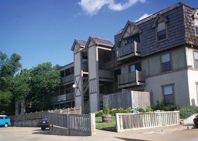
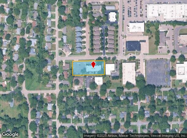
Property Record
4301 Sw 15Th St, Topeka, KS 66604
NEARBY LISTINGS FOR SALE OR LEASE
Property Detail
4301 Sw 15Th St
Topeka, KS
Gage Sub
142-03-0-10-09-004-000
GAGE SUB , BLOCK D , LOT 19 + , SW 15TH ST BLK D LOT 19-20 GAGE SUB SECTION 03 TOWNSHIP 12 RANGE 15
Apartment
Shawnee
X
Kansas
20177C0215E
19
2024
1 AC
2025
McAlister Parkway
002500
Kansas City
21,909 SF
DEMOGRAPHICS near 4301 Sw 15Th St
1 Mile
3 Mile
5 Mile
2024 Total Population
9,434
71,602
123,723
2029 Population
9,242
70,972
122,812
Pop Growth 2024-2029
(2.04%)
(0.88%)
(0.74%)
Average Age
44
41
40
2024 Total Households
4,602
32,763
52,777
HH Growth 2024-2029
(2.17%)
(0.96%)
(0.80%)
Median Household Inc
$59,062
$50,533
$49,923
Avg Household Size
2.00
2.10
2.20
2024 Avg HH Vehicles
2.00
2.00
2.00
Median Home Value
$126,842
$128,198
$127,838
Median Year Built
1957
1965
1968
Nearby Places
Map Layers
Map Styles
 Street
 Aerial
- Restaurants
- Banks
- Shops
- Fitness
- Groceries
PUBLIC TRANSPORTATION
COMMUTER RAIL
Topeka Amtrak Station (Southwest Chief - Amtrak)
DRIVE
WALK
Distance
Topeka Amtrak Station (Southwest Chief - Amtrak)
8 min
4.2 mi
Freight Ports
Tulsa Port Of Catoosa
DRIVE
WALK
Distance
Tulsa Port Of Catoosa
275 min
225.4 mi
Nearby Properties
Address
Land Use
TOTAL SIZE
Lot Size
Zoning
Address
Land Use
TOTAL SIZE
Lot Size
Zoning
249,598 SF
150.21 AC
U1
Address
Land Use
TOTAL SIZE
Lot Size
Zoning
513,835 SF
13.39 AC
M1
Address
Land Use
TOTAL SIZE
Lot Size
Zoning
52,453 SF
17.12 AC
C5,OI2
Address
Land Use
TOTAL SIZE
Lot Size
Zoning
309,298 SF
7.34 AC
M1
Address
Land Use
TOTAL SIZE
Lot Size
Zoning
117,839 SF
121.95 AC
R1
Address
Land Use
TOTAL SIZE
Lot Size
Zoning
64,058 SF
3.31 AC
C4,OI2
Address
Land Use
TOTAL SIZE
Lot Size
Zoning
336,669 SF
58.82 AC
PUD,C4
Address
Land Use
TOTAL SIZE
Lot Size
Zoning
3.31 AC
OI2
Address
Land Use
TOTAL SIZE
Lot Size
Zoning
77,776 SF
10.64 AC
PUD,M2,R1,
Address
Land Use
TOTAL SIZE
Lot Size
Zoning
80,630 SF
107.16 AC
R1
Address
Land Use
TOTAL SIZE
Lot Size
Zoning
285,005 SF
3.10 AC
C4,C5,I1
Address
Land Use
TOTAL SIZE
Lot Size
Zoning
19,120 SF
2.08 AC
R1
Address
Land Use
TOTAL SIZE
Lot Size
Zoning
43,282 SF
19.33 AC
PUD,M2
Address
Land Use
TOTAL SIZE
Lot Size
Zoning
137,637 SF
10.43 AC
M2
Address
Land Use
TOTAL SIZE
Lot Size
Zoning
32,544 SF
17.25 AC
PUD
Address
Land Use
TOTAL SIZE
Lot Size
Zoning
90,929 SF
8.68 AC
PUD,OI3,I1
Address
Land Use
TOTAL SIZE
Lot Size
Zoning
114,523 SF
6.92 AC
OI3
Address
Land Use
TOTAL SIZE
Lot Size
Zoning
218,962 SF
49.63 AC
R1
Address
Land Use
TOTAL SIZE
Lot Size
Zoning
152,049 SF
25.61 AC
R1
Address
Land Use
TOTAL SIZE
Lot Size
Zoning
98,898 SF
1.91 AC
C5
Address
Land Use
TOTAL SIZE
Lot Size
Zoning
107,592 SF
14.98 AC
C4,I1,OI2
Address
Land Use
TOTAL SIZE
Lot Size
Zoning
94,830 SF
17.09 AC
PUD,M4
Address
Land Use
TOTAL SIZE
Lot Size
Zoning
208,685 SF
38.23 AC
R1
Address
Land Use
TOTAL SIZE
Lot Size
Zoning
123,795 SF
16.45 AC
PUD,R1,I1,
Address
Land Use
TOTAL SIZE
Lot Size
Zoning
70,578 SF
10.16 AC
PUD,C2
Address
Land Use
TOTAL SIZE
Lot Size
Zoning
52,375 SF
12.94 AC
RR1
Address
Land Use
TOTAL SIZE
Lot Size
Zoning
54,654 SF
0.56 AC
C5
Address
Land Use
TOTAL SIZE
Lot Size
Zoning
175,246 SF
80.42 AC
R1
Address
Land Use
TOTAL SIZE
Lot Size
Zoning
112,413 SF
0.73 AC
C5
Address
Land Use
TOTAL SIZE
Lot Size
Zoning
22,484 SF
75.33 AC
R1
The World's #1 Commercial Real Estate Marketplace
Connect with us
© 2025 CoStar Group
The information above has been obtained from sources believed reliable. While we do not doubt its accuracy we have not verified it and make no guarantee, warranty or representation about it. It is your responsibility to independently confirm its accuracy and completeness. Any projections, opinions, assumptions, or estimates used are for example only and do not represent the current or future performance of the property. The value of this transaction to you depends on tax and other factors which should be evaluated by your tax, financial, and legal advisors. You and your advisors should conduct a careful, independent investigation of the property to determine to your satisfaction the suitability of the property for your needs.