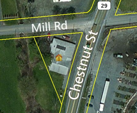
Property Record
4302 Chestnut St, Emmaus, PA 18049

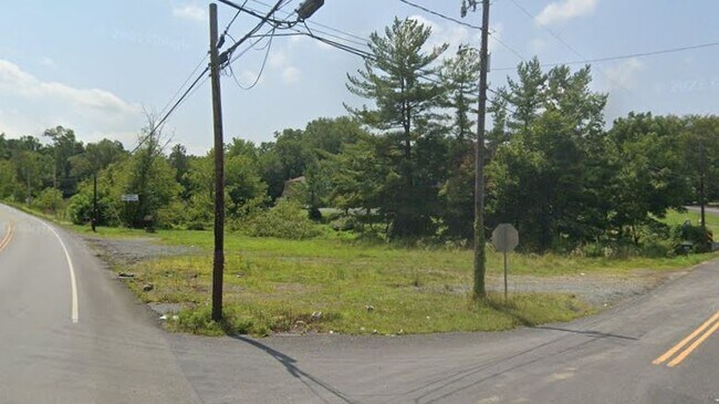
This Property Is For Sale
NEARBY LISTINGS FOR SALE OR LEASE
-
-
View all Emmaus listings for sale on LoopNet.com
Property Detail
4302 Chestnut St
548377193815-1
LOTS: 002
Commercialacreage
Lehigh
X
Pennsylvania
42011C0250G
2
2025
0.60 AC
2025
Lehigh Valley
006500
Philadelphia
4,151 SF
Allentown-Bethlehem-Easton, PA-NJ
DEMOGRAPHICS near 4302 Chestnut St
1 Mile
3 Mile
5 Mile
2024 Total Population
2,453
34,747
82,691
2029 Population
2,481
34,884
83,081
Pop Growth 2024-2029
+ 1.14%
+ 0.39%
+ 0.47%
Average Age
45
42
42
2024 Total Households
1,002
14,201
32,597
HH Growth 2024-2029
+ 1.10%
+ 0.35%
+ 0.43%
Median Household Inc
$87,202
$89,234
$89,475
Avg Household Size
2.40
2.40
2.50
2024 Avg HH Vehicles
3.00
2.00
2.00
Median Home Value
$329,087
$297,327
$293,053
Median Year Built
1982
1981
1978
Nearby Places
Map Layers
Map Styles
 Street
 Aerial
- Restaurants
- Banks
- Shops
- Fitness
- Groceries
PUBLIC TRANSPORTATION
AIRPORT
Lehigh Valley International
DRIVE
WALK
Distance
Lehigh Valley International
26 min
13.4 mi
Freight Ports
Port of Philadelphia
DRIVE
WALK
Distance
Port of Philadelphia
85 min
56.9 mi
Nearby Properties
Address
Land Use
TOTAL SIZE
Lot Size
Zoning
Address
Land Use
TOTAL SIZE
Lot Size
Zoning
413,834 SF
40 AC
R-L
Address
Land Use
TOTAL SIZE
Lot Size
Zoning
199,343 SF
48.68 AC
O
Address
Land Use
TOTAL SIZE
Lot Size
Zoning
7,132 SF
21.72 AC
C
Address
Land Use
TOTAL SIZE
Lot Size
Zoning
32,500 SF
147.04 AC
I
Address
Land Use
TOTAL SIZE
Lot Size
Zoning
44,302 SF
17.25 AC
I-L
Address
Land Use
TOTAL SIZE
Lot Size
Zoning
85,585 SF
24.47 AC
SR
Address
Land Use
TOTAL SIZE
Lot Size
Zoning
210,000 SF
20.53 AC
I
Address
Land Use
TOTAL SIZE
Lot Size
Zoning
15,472 SF
10.40 AC
R-7.
Address
Land Use
TOTAL SIZE
Lot Size
Zoning
1,922 SF
44.40 AC
I
Address
Land Use
TOTAL SIZE
Lot Size
Zoning
14,330 SF
11.32 AC
R-M
Address
Land Use
TOTAL SIZE
Lot Size
Zoning
2,866 SF
12.21 AC
R-M
Address
Land Use
TOTAL SIZE
Lot Size
Zoning
13,160 SF
6.90 AC
R-L
Address
Land Use
TOTAL SIZE
Lot Size
Zoning
19,124 SF
14.03 AC
R-P
Address
Land Use
TOTAL SIZE
Lot Size
Zoning
22,380 SF
13.79 AC
R-P
Address
Land Use
TOTAL SIZE
Lot Size
Zoning
43,702 SF
1.98 AC
R-HO
Address
Land Use
TOTAL SIZE
Lot Size
Zoning
60,141 SF
0.76 AC
R-HO
Address
Land Use
TOTAL SIZE
Lot Size
Zoning
70,230 SF
13.07 AC
C
Address
Land Use
TOTAL SIZE
Lot Size
Zoning
6,725 SF
6.13 AC
R-7.
Address
Land Use
TOTAL SIZE
Lot Size
Zoning
40.21 AC
S
Address
Land Use
TOTAL SIZE
Lot Size
Zoning
29,496 SF
22.56 AC
O
Address
Land Use
TOTAL SIZE
Lot Size
Zoning
30,051 SF
4.68 AC
C
Address
Land Use
TOTAL SIZE
Lot Size
Zoning
224,173 SF
16.56 AC
M
Address
Land Use
TOTAL SIZE
Lot Size
Zoning
21,958 SF
1.08 AC
R-HO
Address
Land Use
TOTAL SIZE
Lot Size
Zoning
29.10 AC
I
Address
Land Use
TOTAL SIZE
Lot Size
Zoning
288,856 SF
10.28 AC
S
Address
Land Use
TOTAL SIZE
Lot Size
Zoning
32.78 AC
I
Address
Land Use
TOTAL SIZE
Lot Size
Zoning
58,376 SF
4.98 AC
I-L
Address
Land Use
TOTAL SIZE
Lot Size
Zoning
35,552 SF
2.19 AC
R-M
Address
Land Use
TOTAL SIZE
Lot Size
Zoning
44,337 SF
18.13 AC
I
Address
Land Use
TOTAL SIZE
Lot Size
Zoning
22,551 SF
2.37 AC
C
The World's #1 Commercial Real Estate Marketplace
Connect with us
© 2025 CoStar Group
The information above has been obtained from sources believed reliable. While we do not doubt its accuracy we have not verified it and make no guarantee, warranty or representation about it. It is your responsibility to independently confirm its accuracy and completeness. Any projections, opinions, assumptions, or estimates used are for example only and do not represent the current or future performance of the property. The value of this transaction to you depends on tax and other factors which should be evaluated by your tax, financial, and legal advisors. You and your advisors should conduct a careful, independent investigation of the property to determine to your satisfaction the suitability of the property for your needs.