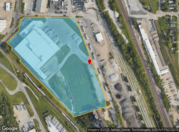
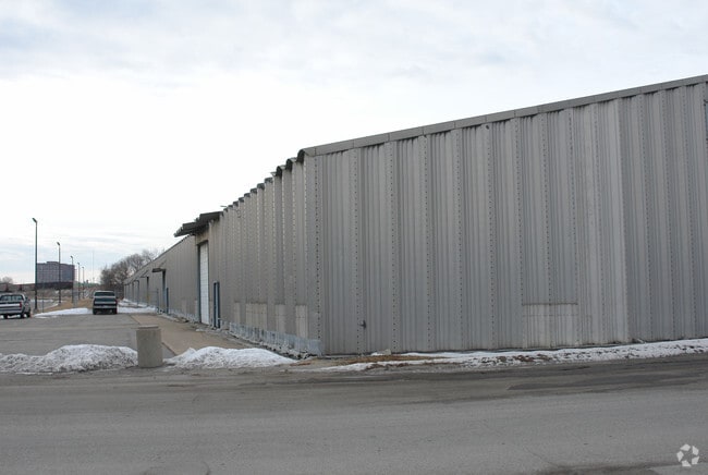
Property Record
4302 S 30Th St, Omaha, NE 68107

NEARBY LISTINGS FOR SALE OR LEASE
Property Detail
4302 S 30Th St
Omaha-Council Bluffs, NE-IA
United States Cold Storage Add
3978-1002-23
UNITED STATES COLD STORAGE ADD LOT 1 BLOCK 0 IRREG 13.49 AC EXCESS REDEVELOPMENT PROJECT VALUE
Shipyard
Douglas
X
Nebraska
31153C0080G
1
2024
13.49 AC
2025
Southeast Omaha
003100
Omaha/Council Bluffs
126,910 SF
DEMOGRAPHICS near 4302 S 30Th St
1 Mile
3 Mile
5 Mile
2024 Total Population
12,588
112,257
246,070
2029 Population
12,698
114,654
252,843
Pop Growth 2024-2029
+ 0.87%
+ 2.14%
+ 2.75%
Average Age
34
36
36
2024 Total Households
4,116
43,635
98,630
HH Growth 2024-2029
+ 0.90%
+ 2.38%
+ 2.89%
Median Household Inc
$46,267
$53,019
$56,722
Avg Household Size
2.90
2.40
2.30
2024 Avg HH Vehicles
2.00
2.00
2.00
Median Home Value
$137,138
$156,458
$178,459
Median Year Built
1948
1953
1961
Nearby Places
Map Layers
Map Styles
 Street
 Aerial
- Restaurants
- Banks
- Shops
- Fitness
- Groceries
PUBLIC TRANSPORTATION
COMMUTER RAIL
Omaha Amtrak Station (California Zephyr - Amtrak)
DRIVE
WALK
Distance
Omaha Amtrak Station (California Zephyr - Amtrak)
8 min
4.1 mi
Omaha Amtrak Station (California Zephyr - Amtrak)
DRIVE
WALK
Distance
Omaha Amtrak Station (California Zephyr - Amtrak)
8 min
4.3 mi
AIRPORT
Eppley Airfield
DRIVE
WALK
Distance
Eppley Airfield
16 min
8.2 mi
Freight Ports
Tulsa Port Of Catoosa
DRIVE
WALK
Distance
Tulsa Port Of Catoosa
460 min
416.0 mi
Nearby Properties
Address
Land Use
TOTAL SIZE
Lot Size
Zoning
Address
Land Use
TOTAL SIZE
Lot Size
Zoning
1,027,620 SF
4.33 AC
Address
Land Use
TOTAL SIZE
Lot Size
Zoning
276,622 SF
3.90 AC
Address
Land Use
TOTAL SIZE
Lot Size
Zoning
346,816 SF
0.80 AC
Address
Land Use
TOTAL SIZE
Lot Size
Zoning
206,591 SF
0.60 AC
Address
Land Use
TOTAL SIZE
Lot Size
Zoning
335,431 SF
0.79 AC
Address
Land Use
TOTAL SIZE
Lot Size
Zoning
27.38 AC
I-2
Address
Land Use
TOTAL SIZE
Lot Size
Zoning
140,130 SF
1.89 AC
Address
Land Use
TOTAL SIZE
Lot Size
Zoning
149,737 SF
1.93 AC
Address
Land Use
TOTAL SIZE
Lot Size
Zoning
198,447 SF
1.36 AC
Address
Land Use
TOTAL SIZE
Lot Size
Zoning
97,617 SF
49.05 AC
Address
Land Use
TOTAL SIZE
Lot Size
Zoning
199,734 SF
3.10 AC
Address
Land Use
TOTAL SIZE
Lot Size
Zoning
189,690 SF
0.57 AC
Address
Land Use
TOTAL SIZE
Lot Size
Zoning
215,353 SF
1.77 AC
Address
Land Use
TOTAL SIZE
Lot Size
Zoning
105,193 SF
1.52 AC
Address
Land Use
TOTAL SIZE
Lot Size
Zoning
247,802 SF
0.98 AC
Address
Land Use
TOTAL SIZE
Lot Size
Zoning
154,493 SF
0.80 AC
Address
Land Use
TOTAL SIZE
Lot Size
Zoning
148,789 SF
2.52 AC
Address
Land Use
TOTAL SIZE
Lot Size
Zoning
158,547 SF
1.81 AC
Address
Land Use
TOTAL SIZE
Lot Size
Zoning
628,656 SF
2.76 AC
MU
Address
Land Use
TOTAL SIZE
Lot Size
Zoning
158,816 SF
0.40 AC
Address
Land Use
TOTAL SIZE
Lot Size
Zoning
185,179 SF
2.64 AC
Address
Land Use
TOTAL SIZE
Lot Size
Zoning
168,155 SF
0.30 AC
CBD
Address
Land Use
TOTAL SIZE
Lot Size
Zoning
191,768 SF
3.08 AC
Address
Land Use
TOTAL SIZE
Lot Size
Zoning
105,219 SF
0.40 AC
Address
Land Use
TOTAL SIZE
Lot Size
Zoning
32.10 AC
I-2
Address
Land Use
TOTAL SIZE
Lot Size
Zoning
134,725 SF
0.68 AC
Address
Land Use
TOTAL SIZE
Lot Size
Zoning
100,436 SF
0.93 AC
Address
Land Use
TOTAL SIZE
Lot Size
Zoning
69,043 SF
0.73 AC
Address
Land Use
TOTAL SIZE
Lot Size
Zoning
159,534 SF
The World's #1 Commercial Real Estate Marketplace
Connect with us
© 2026 CoStar Group
The information above has been obtained from sources believed reliable. While we do not doubt its accuracy we have not verified it and make no guarantee, warranty or representation about it. It is your responsibility to independently confirm its accuracy and completeness. Any projections, opinions, assumptions, or estimates used are for example only and do not represent the current or future performance of the property. The value of this transaction to you depends on tax and other factors which should be evaluated by your tax, financial, and legal advisors. You and your advisors should conduct a careful, independent investigation of the property to determine to your satisfaction the suitability of the property for your needs.