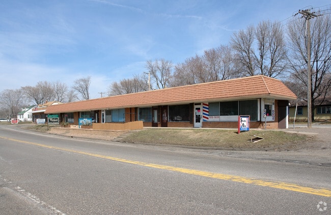
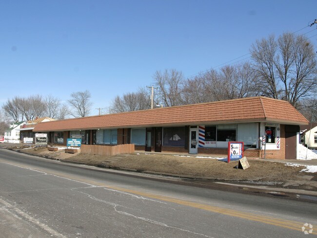
Property Record
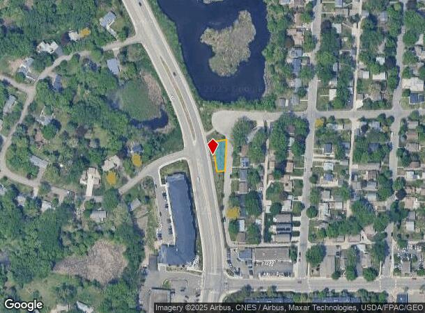
4303 Shady Oak Rd S, Hopkins, MN 55343
NEARBY LISTINGS FOR SALE OR LEASE
Property Detail
4303 Shady Oak Rd S
23-117-22-42-0002
Unplatted 23 117 22
Commercialacreage
UNPLATTED 23 117 22 COM AT A PT IN E LINE OF W 1/2 OF SE 1/4 DIS 33 5/10 FT N FROM CTR LINE OF EXCELSIOR AVE TH N 15 DEG 50 MIN W 534 2/10 FT TO T IRREGULAR
X
Hennepin
27053C0341F
Minnesota
0
0.12 AC
2024
Ridgedale
026103
Minneapolis/St Paul
1,564 SF
Minneapolis-St. Paul-Bloomington, MN-WI
DEMOGRAPHICS near 4303 Shady Oak Rd S
1 Mile
3 Mile
5 Mile
2024 Total Population
9,932
71,458
189,230
2029 Population
9,794
70,514
186,518
Pop Growth 2024-2029
(1.39%)
(1.32%)
(1.43%)
Average Age
42
42
42
2024 Total Households
4,482
32,289
82,569
HH Growth 2024-2029
(1.56%)
(1.45%)
(1.48%)
Median Household Inc
$76,782
$87,950
$102,038
Avg Household Size
2.20
2.10
2.20
2024 Avg HH Vehicles
2.00
2.00
2.00
Median Home Value
$368,541
$378,251
$421,374
Median Year Built
1966
1975
1974
Nearby Places
Map Layers
Map Styles
 Street
 Aerial
- Restaurants
- Banks
- Shops
- Fitness
- Groceries
PUBLIC TRANSPORTATION
AIRPORT
Minneapolis-St Paul International/Wold-Chamberlain
DRIVE
WALK
Distance
Minneapolis-St Paul International/Wold-Chamberlain
25 min
16.1 mi
Freight Ports
Port Milwaukee
DRIVE
WALK
Distance
Port Milwaukee
390 min
349.0 mi
Nearby Properties
Address
Land Use
TOTAL SIZE
Lot Size
Zoning
Address
Land Use
TOTAL SIZE
Lot Size
Zoning
18.27 AC
Address
Land Use
TOTAL SIZE
Lot Size
Zoning
7.68 AC
Address
Land Use
TOTAL SIZE
Lot Size
Zoning
4.89 AC
Address
Land Use
TOTAL SIZE
Lot Size
Zoning
6.83 AC
Address
Land Use
TOTAL SIZE
Lot Size
Zoning
0.90 AC
Address
Land Use
TOTAL SIZE
Lot Size
Zoning
3.07 AC
Address
Land Use
TOTAL SIZE
Lot Size
Zoning
4.84 AC
Address
Land Use
TOTAL SIZE
Lot Size
Zoning
138,997 SF
14.03 AC
OFC
Address
Land Use
TOTAL SIZE
Lot Size
Zoning
4.55 AC
Address
Land Use
TOTAL SIZE
Lot Size
Zoning
3.15 AC
Address
Land Use
TOTAL SIZE
Lot Size
Zoning
19.75 AC
Address
Land Use
TOTAL SIZE
Lot Size
Zoning
233,320 SF
17.37 AC
PUD
Address
Land Use
TOTAL SIZE
Lot Size
Zoning
93,982 SF
9.33 AC
OFC
Address
Land Use
TOTAL SIZE
Lot Size
Zoning
224,581 SF
13.72 AC
PUD
Address
Land Use
TOTAL SIZE
Lot Size
Zoning
19.46 AC
PUD
Address
Land Use
TOTAL SIZE
Lot Size
Zoning
38.20 AC
Address
Land Use
TOTAL SIZE
Lot Size
Zoning
2.38 AC
Address
Land Use
TOTAL SIZE
Lot Size
Zoning
127,084 SF
17.21 AC
Address
Land Use
TOTAL SIZE
Lot Size
Zoning
244,941 SF
5.24 AC
Address
Land Use
TOTAL SIZE
Lot Size
Zoning
13.80 AC
Address
Land Use
TOTAL SIZE
Lot Size
Zoning
73,905 SF
11.66 AC
B3
Address
Land Use
TOTAL SIZE
Lot Size
Zoning
94,155 SF
2.06 AC
PUD
Address
Land Use
TOTAL SIZE
Lot Size
Zoning
1.55 AC
Address
Land Use
TOTAL SIZE
Lot Size
Zoning
7.06 AC
Address
Land Use
TOTAL SIZE
Lot Size
Zoning
41,398 SF
6.78 AC
PUD
Address
Land Use
TOTAL SIZE
Lot Size
Zoning
7.32 AC
Address
Land Use
TOTAL SIZE
Lot Size
Zoning
32,373 SF
3.82 AC
PUD
Address
Land Use
TOTAL SIZE
Lot Size
Zoning
206,232 SF
6.65 AC
Address
Land Use
TOTAL SIZE
Lot Size
Zoning
122,801 SF
8.41 AC
RM25
Address
Land Use
TOTAL SIZE
Lot Size
Zoning
13.43 AC
The World's #1 Commercial Real Estate Marketplace
Connect with us
© 2025 CoStar Group
The information above has been obtained from sources believed reliable. While we do not doubt its accuracy we have not verified it and make no guarantee, warranty or representation about it. It is your responsibility to independently confirm its accuracy and completeness. Any projections, opinions, assumptions, or estimates used are for example only and do not represent the current or future performance of the property. The value of this transaction to you depends on tax and other factors which should be evaluated by your tax, financial, and legal advisors. You and your advisors should conduct a careful, independent investigation of the property to determine to your satisfaction the suitability of the property for your needs.