Property Record
4304 3Rd Ave S, Birmingham, AL 35222

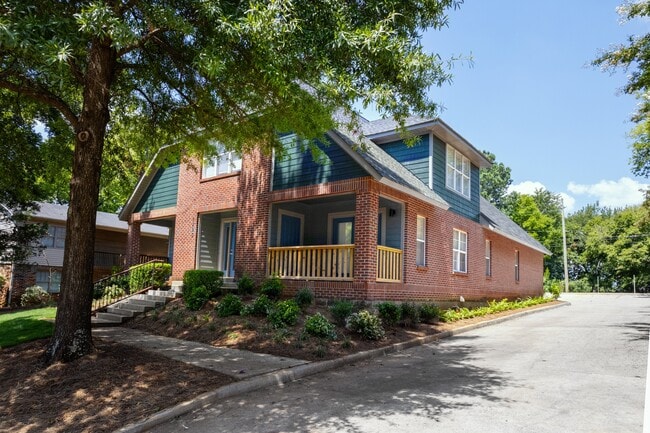
Property Detail
4304 3Rd Ave S
23-00-29-4-005-002.000
LOT 1-A BLK 3 AVONDALE GARDENS PB 212 PG 73
Apartment
JEFFERSON
CB2
Alabama
B and X Area of moderate flood hazard, usually the area between the limits of the 100-year and 500-year floods.
1-a
0
0.34 AC
2025
Avondale
002401
Birmingham
5,292 SF
Birmingham, AL
NEARBY LISTINGS FOR SALE OR LEASE
DEMOGRAPHICS near 4304 3Rd Ave S
1 mile
3 mile
5 mile
2025 Total Population
7,924
69,418
160,685
2030 Population
7,808
69,478
161,286
Pop Growth 2025-2030
(1.46%)
+ 0.09%
+ 0.37%
Average Age
38
38
39
2025 Total Households
3,767
31,129
68,410
HH Growth 2025-2030
(1.43%)
(0.01%)
+ 0.30%
Median Household Inc
$70,362
$57,599
$55,576
Avg Household Size
2.00
2.00
2.10
2025 Avg HH Vehicles
2.00
1.00
2.00
Median Home Value
$386,408
$382,112
$340,734
Median Year Built
1960
1963
1965
Nearby Places
Map Layers
Map Styles
 Street
 Aerial
Layers
 Traffic
 Biking
Places
Listings with unknown addresses are not visible on the map
- Restaurants
- Banks
- Shops
- Fitness
- Groceries
PUBLIC TRANSPORTATION
AIRPORT
Birmingham-Shuttlesworth International
Drive
Walk
Distance
Birmingham-Shuttlesworth International
10 min
3.8 mi
Freight Ports
Port of Mobile
Drive
Walk
Distance
Port of Mobile
1 min
209.2 mi
Nearby Properties
Address
Land Use
TOTAL SIZE
Lot Size
Zoning
Address
Land Use
TOTAL SIZE
Lot Size
Zoning
296,284 SF
12 AC
OI
Address
Land Use
TOTAL SIZE
Lot Size
Zoning
305,826 SF
4 AC
B4
Address
Land Use
TOTAL SIZE
Lot Size
Zoning
189,447 SF
4 AC
B4
Address
Land Use
TOTAL SIZE
Lot Size
Zoning
145,865 SF
142 AC
M1-M
Address
Land Use
TOTAL SIZE
Lot Size
Zoning
224,049 SF
4 AC
M1
Address
Land Use
TOTAL SIZE
Lot Size
Zoning
239,334 SF
4 AC
B6
Address
Land Use
TOTAL SIZE
Lot Size
Zoning
183,862 SF
10 AC
B4
Address
Land Use
TOTAL SIZE
Lot Size
Zoning
230,441 SF
10 AC
M1
Address
Land Use
TOTAL SIZE
Lot Size
Zoning
106,144 SF
1 AC
B4
Address
Land Use
TOTAL SIZE
Lot Size
Zoning
94,958 SF
4 AC
M1
Address
Land Use
TOTAL SIZE
Lot Size
Zoning
334,463 SF
2 AC
B4
Address
Land Use
TOTAL SIZE
Lot Size
Zoning
154,474 SF
12.50 AC
R-D
Address
Land Use
TOTAL SIZE
Lot Size
Zoning
57,066 SF
1 AC
B4
Address
Land Use
TOTAL SIZE
Lot Size
Zoning
298,966 SF
73 AC
M1
Address
Land Use
TOTAL SIZE
Lot Size
Zoning
46,161 SF
1 AC
M1-B
Address
Land Use
TOTAL SIZE
Lot Size
Zoning
95,993 SF
3.67 AC
M1
Address
Land Use
TOTAL SIZE
Lot Size
Zoning
229,669 SF
2.75 AC
B4
Address
Land Use
TOTAL SIZE
Lot Size
Zoning
109,411 SF
3 AC
B4
Address
Land Use
TOTAL SIZE
Lot Size
Zoning
2 AC
M1-B
Address
Land Use
TOTAL SIZE
Lot Size
Zoning
1,666 SF
2 AC
M1
Address
Land Use
TOTAL SIZE
Lot Size
Zoning
30,453 SF
0.87 AC
B2
Address
Land Use
TOTAL SIZE
Lot Size
Zoning
2 AC
B4
Address
Land Use
TOTAL SIZE
Lot Size
Zoning
29,136 SF
2 AC
B4
Address
Land Use
TOTAL SIZE
Lot Size
Zoning
79,458 SF
1 AC
B4
Address
Land Use
TOTAL SIZE
Lot Size
Zoning
109,819 SF
2.91 AC
M2
Address
Land Use
TOTAL SIZE
Lot Size
Zoning
134,574 SF
15 AC
Address
Land Use
TOTAL SIZE
Lot Size
Zoning
62,350 SF
1.29 AC
B-4
Address
Land Use
TOTAL SIZE
Lot Size
Zoning
156,986 SF
1.29 AC
M1
Address
Land Use
TOTAL SIZE
Lot Size
Zoning
96,102 SF
1.74 AC
B4
Address
Land Use
TOTAL SIZE
Lot Size
Zoning
2 AC
B4
The World's #1 Commercial Real Estate Marketplace
Connect with us
© 2026 CoStar Group
The information above has been obtained from sources believed reliable. While we do not doubt its accuracy we have not verified it and make no guarantee, warranty or representation about it. It is your responsibility to independently confirm its accuracy and completeness. Any projections, opinions, assumptions, or estimates used are for example only and do not represent the current or future performance of the property. The value of this transaction to you depends on tax and other factors which should be evaluated by your tax, financial, and legal advisors. You and your advisors should conduct a careful, independent investigation of the property to determine to your satisfaction the suitability of the property for your needs.