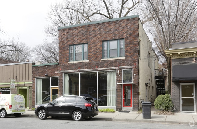
Property Record
4304 Bryant Ave S, Minneapolis, MN 55409

Current Lease Availabilities
NEARBY LISTINGS FOR SALE OR LEASE
Property Detail
4304 Bryant Ave S
Minneapolis-St. Paul-Bloomington, MN-WI
Remingtons 3Rd Addn To Mpls
09-028-24-41-0121
LOT 002 BLOCK 043 A REMINGTONS 3RD ADDN TO MPLS THAT PART LYING E OF W 40 FT 42.00 X 94.40
Commercialnec
Hennepin
X
Minnesota
27053C0366F
2
2024
0.09 AC
2024
I-394 Corridor
109900
Minneapolis/St Paul
4,720 SF
DEMOGRAPHICS near 4304 Bryant Ave S
1 Mile
3 Mile
5 Mile
2024 Total Population
17,123
208,261
468,816
2029 Population
16,663
204,755
462,220
Pop Growth 2024-2029
(2.69%)
(1.68%)
(1.41%)
Average Age
40
38
38
2024 Total Households
7,332
93,096
211,596
HH Growth 2024-2029
(2.78%)
(1.69%)
(1.34%)
Median Household Inc
$101,632
$81,184
$75,937
Avg Household Size
2.20
2.10
2.10
2024 Avg HH Vehicles
2.00
1.00
1.00
Median Home Value
$418,602
$386,519
$363,847
Median Year Built
1946
1949
1959
Nearby Places
Map Layers
Map Styles
 Street
 Aerial
- Restaurants
- Banks
- Shops
- Fitness
- Groceries
PUBLIC TRANSPORTATION
COMMUTER RAIL
Target Field Station (Northstar Corridor - Northstar Commuter Rail)
DRIVE
WALK
Distance
Target Field Station (Northstar Corridor - Northstar Commuter Rail)
14 min
6.1 mi
AIRPORT
Minneapolis-St Paul International/Wold-Chamberlain
DRIVE
WALK
Distance
Minneapolis-St Paul International/Wold-Chamberlain
19 min
10.1 mi
Nearby Properties
Address
Land Use
TOTAL SIZE
Lot Size
Zoning
Address
Land Use
TOTAL SIZE
Lot Size
Zoning
275,782 SF
2.40 AC
C3A
Address
Land Use
TOTAL SIZE
Lot Size
Zoning
659,076 SF
1.45 AC
C3A
Address
Land Use
TOTAL SIZE
Lot Size
Zoning
1.50 AC
Address
Land Use
TOTAL SIZE
Lot Size
Zoning
Address
Land Use
TOTAL SIZE
Lot Size
Zoning
4,497,396 SF
11.05 AC
Address
Land Use
TOTAL SIZE
Lot Size
Zoning
264,176 SF
1.61 AC
OR2
Address
Land Use
TOTAL SIZE
Lot Size
Zoning
390,060 SF
3.11 AC
Address
Land Use
TOTAL SIZE
Lot Size
Zoning
406,842 SF
1.59 AC
Address
Land Use
TOTAL SIZE
Lot Size
Zoning
398,595 SF
1.91 AC
Address
Land Use
TOTAL SIZE
Lot Size
Zoning
288,096 SF
10.19 AC
Address
Land Use
TOTAL SIZE
Lot Size
Zoning
379,488 SF
2.68 AC
Address
Land Use
TOTAL SIZE
Lot Size
Zoning
340,330 SF
2.22 AC
Address
Land Use
TOTAL SIZE
Lot Size
Zoning
233,886 SF
1.63 AC
R5
Address
Land Use
TOTAL SIZE
Lot Size
Zoning
Address
Land Use
TOTAL SIZE
Lot Size
Zoning
2.23 AC
Address
Land Use
TOTAL SIZE
Lot Size
Zoning
239,539 SF
1.29 AC
OR2
Address
Land Use
TOTAL SIZE
Lot Size
Zoning
295,036 SF
1.82 AC
R6
Address
Land Use
TOTAL SIZE
Lot Size
Zoning
424,327 SF
2.16 AC
Address
Land Use
TOTAL SIZE
Lot Size
Zoning
346,787 SF
1.94 AC
R3
Address
Land Use
TOTAL SIZE
Lot Size
Zoning
186,691 SF
0.80 AC
C3A
Address
Land Use
TOTAL SIZE
Lot Size
Zoning
263,948 SF
2.73 AC
R6
Address
Land Use
TOTAL SIZE
Lot Size
Zoning
247,643 SF
2.58 AC
Address
Land Use
TOTAL SIZE
Lot Size
Zoning
160,202 SF
0.74 AC
C3A
Address
Land Use
TOTAL SIZE
Lot Size
Zoning
179,243 SF
1.05 AC
C2
Address
Land Use
TOTAL SIZE
Lot Size
Zoning
186,761 SF
1.14 AC
C3A
Address
Land Use
TOTAL SIZE
Lot Size
Zoning
4,900 SF
1.59 AC
Address
Land Use
TOTAL SIZE
Lot Size
Zoning
2.01 AC
Address
Land Use
TOTAL SIZE
Lot Size
Zoning
283,912 SF
2.17 AC
R6
Address
Land Use
TOTAL SIZE
Lot Size
Zoning
307,923 SF
1.33 AC
R5
Address
Land Use
TOTAL SIZE
Lot Size
Zoning
184,111 SF
0.29 AC
C3A
The World's #1 Commercial Real Estate Marketplace
Connect with us
© 2025 CoStar Group
The information above has been obtained from sources believed reliable. While we do not doubt its accuracy we have not verified it and make no guarantee, warranty or representation about it. It is your responsibility to independently confirm its accuracy and completeness. Any projections, opinions, assumptions, or estimates used are for example only and do not represent the current or future performance of the property. The value of this transaction to you depends on tax and other factors which should be evaluated by your tax, financial, and legal advisors. You and your advisors should conduct a careful, independent investigation of the property to determine to your satisfaction the suitability of the property for your needs.