Property Record
4320 Us Highway 17 92 N, Davenport, FL 33837
This Property Is For Sale
NEARBY LISTINGS FOR SALE OR LEASE
Property Detail
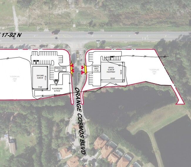
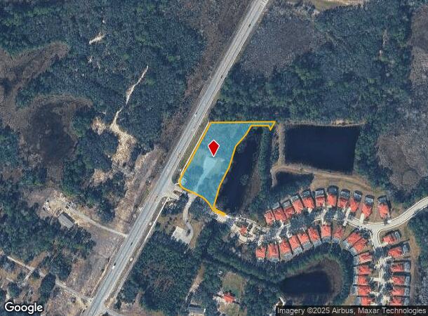
4320 Us Highway 17 92 N
Lakeland-Winter Haven, FL
Watersong Phase One
27-26-24-706191-002110
WATERSONG PHASE ONE PB 135 PGS 45-52 TRACT A (COMMERCIAL AREA) LESS R/W PCL 502 FOR SR 600 (US HWY 17/92) AS DESC IN OR 7644 PG 1324 & LESS BEG INT OF ELY R/W OF US HWY 17 & 92 & NLY R/W OF ORANGE COSMOS BLVD RUN N28-25-38E 8 FT S63-46-09E 45 FT S25-
Commercialnec
Polk
AE
Florida
12105C0230H
1.67 AC
2023
Polk County
2025
Tampa/St Petersburg
012508
DEMOGRAPHICS near 4320 Us Highway 17 92 N
1 Mile
3 Mile
5 Mile
2024 Total Population
3,060
24,877
77,685
2029 Population
3,849
30,988
96,785
Pop Growth 2024-2029
+ 25.78%
+ 24.56%
+ 24.59%
Average Age
36
37
39
2024 Total Households
997
8,575
27,851
HH Growth 2024-2029
+ 25.68%
+ 24.47%
+ 24.63%
Median Household Inc
$38,541
$59,190
$62,834
Avg Household Size
3.00
2.90
2.70
2024 Avg HH Vehicles
2.00
2.00
2.00
Median Home Value
$353,793
$284,309
$262,838
Median Year Built
2010
2007
2007
Nearby Places
- Restaurants
- Banks
- Shops
- Fitness
- Groceries
PUBLIC TRANSPORTATION
COMMUTER RAIL
Poinciana (SunRail - Florida Department of Transportation)
DRIVE
WALK
Distance
Poinciana (SunRail - Florida Department of Transportation)
11 min
7.5 mi
AIRPORT
Orlando International
DRIVE
WALK
Distance
Orlando International
44 min
32.0 mi
Freight Ports
Port of Tampa Bay
DRIVE
WALK
Distance
Port of Tampa Bay
80 min
65.7 mi
Nearby Properties
Address
Land Use
TOTAL SIZE
Lot Size
Zoning
Address
Land Use
TOTAL SIZE
Lot Size
Zoning
417,544 SF
62.60 AC
Address
Land Use
TOTAL SIZE
Lot Size
Zoning
434,491 SF
27.48 AC
Address
Land Use
TOTAL SIZE
Lot Size
Zoning
425,752 SF
19.52 AC
Address
Land Use
TOTAL SIZE
Lot Size
Zoning
336,042 SF
20.77 AC
Address
Land Use
TOTAL SIZE
Lot Size
Zoning
216,296 SF
16.37 AC
Address
Land Use
TOTAL SIZE
Lot Size
Zoning
338,315 SF
59.58 AC
Address
Land Use
TOTAL SIZE
Lot Size
Zoning
148,436 SF
10.27 AC
Address
Land Use
TOTAL SIZE
Lot Size
Zoning
74,571 SF
9.98 AC
Address
Land Use
TOTAL SIZE
Lot Size
Zoning
88,912 SF
24.99 AC
RC
Address
Land Use
TOTAL SIZE
Lot Size
Zoning
28.18 AC
Address
Land Use
TOTAL SIZE
Lot Size
Zoning
112.98 AC
OPUD
Address
Land Use
TOTAL SIZE
Lot Size
Zoning
Address
Land Use
TOTAL SIZE
Lot Size
Zoning
14,660 SF
5.14 AC
Address
Land Use
TOTAL SIZE
Lot Size
Zoning
7.10 AC
RC
Address
Land Use
TOTAL SIZE
Lot Size
Zoning
7.12 AC
Address
Land Use
TOTAL SIZE
Lot Size
Zoning
102.99 AC
Address
Land Use
TOTAL SIZE
Lot Size
Zoning
47,278 SF
23.78 AC
C3
Address
Land Use
TOTAL SIZE
Lot Size
Zoning
4,227 SF
1.33 AC
Address
Land Use
TOTAL SIZE
Lot Size
Zoning
548.44 AC
RC
Address
Land Use
TOTAL SIZE
Lot Size
Zoning
7,569 SF
1.46 AC
XX
Address
Land Use
TOTAL SIZE
Lot Size
Zoning
4.22 AC
Address
Land Use
TOTAL SIZE
Lot Size
Zoning
576 SF
229.36 AC
RC
Address
Land Use
TOTAL SIZE
Lot Size
Zoning
3,124 SF
1.96 AC
Address
Land Use
TOTAL SIZE
Lot Size
Zoning
3,410 SF
1.17 AC
C3
Address
Land Use
TOTAL SIZE
Lot Size
Zoning
4,322 SF
1.09 AC
Address
Land Use
TOTAL SIZE
Lot Size
Zoning
3,978 SF
1.12 AC
Address
Land Use
TOTAL SIZE
Lot Size
Zoning
65.46 AC
Address
Land Use
TOTAL SIZE
Lot Size
Zoning
154.04 AC
RC
Address
Land Use
TOTAL SIZE
Lot Size
Zoning
20.65 AC
XX
Address
Land Use
TOTAL SIZE
Lot Size
Zoning
1,880 SF
1.10 AC
The World's #1 Commercial Real Estate Marketplace
Connect with us
© 2025 CoStar Group
The information above has been obtained from sources believed reliable. While we do not doubt its accuracy we have not verified it and make no guarantee, warranty or representation about it. It is your responsibility to independently confirm its accuracy and completeness. Any projections, opinions, assumptions, or estimates used are for example only and do not represent the current or future performance of the property. The value of this transaction to you depends on tax and other factors which should be evaluated by your tax, financial, and legal advisors. You and your advisors should conduct a careful, independent investigation of the property to determine to your satisfaction the suitability of the property for your needs.