Property Record
4304 Walden Ave, Lancaster, NY 14086
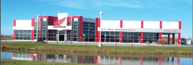


Property Detail
4304 Walden Ave
145289-095-000-0004-038-100
Erie
Industrialgeneral
New York
LI
38.100
B and X Area of moderate flood hazard, usually the area between the limits of the 100-year and 500-year floods.
28.53 AC
2025
East
2025
Buffalo/Niagara Falls
014208
Buffalo-Cheektowaga, NY
24,874 SF
NEARBY LISTINGS FOR SALE OR LEASE
DEMOGRAPHICS near 4304 Walden Ave
1 mile
3 mile
5 mile
2025 Total Population
771
13,102
68,395
2030 Population
779
13,184
68,600
Pop Growth 2025-2030
+ 1.04%
+ 0.63%
+ 0.30%
Average Age
40
45
44
2025 Total Households
276
5,471
28,211
HH Growth 2025-2030
+ 1.09%
+ 0.57%
+ 0.22%
Median Household Inc
$109,936
$80,071
$85,242
Avg Household Size
2.70
2.30
2.30
2025 Avg HH Vehicles
2.00
2.00
2.00
Median Home Value
$338,297
$309,062
$276,213
Median Year Built
1988
1991
1968
Nearby Places
Map Layers
Map Styles
 Street
 Aerial
Layers
 Traffic
 Biking
Places
Listings with unknown addresses are not visible on the map
- Restaurants
- Banks
- Shops
- Fitness
- Groceries
PUBLIC TRANSPORTATION
COMMUTER RAIL
Drive
Walk
Distance
13 min
6.6 mi
AIRPORT
Buffalo Niagara International
Drive
Walk
Distance
Buffalo Niagara International
16 min
8.3 mi
Niagara Falls International
Drive
Walk
Distance
Niagara Falls International
44 min
24.9 mi
Nearby Properties
Address
Land Use
TOTAL SIZE
Lot Size
Zoning
Address
Land Use
TOTAL SIZE
Lot Size
Zoning
65,000 SF
102 AC
C-2
Address
Land Use
TOTAL SIZE
Lot Size
Zoning
868,362 SF
135.20 AC
Address
Land Use
TOTAL SIZE
Lot Size
Zoning
215,000 SF
14.56 AC
Address
Land Use
TOTAL SIZE
Lot Size
Zoning
6,618 SF
36.08 AC
MFMU
Address
Land Use
TOTAL SIZE
Lot Size
Zoning
488,282 SF
32 AC
Address
Land Use
TOTAL SIZE
Lot Size
Zoning
1,235 SF
12.50 AC
COMM
Address
Land Use
TOTAL SIZE
Lot Size
Zoning
320,945 SF
62.80 AC
RES
Address
Land Use
TOTAL SIZE
Lot Size
Zoning
122,494 SF
9.74 AC
Address
Land Use
TOTAL SIZE
Lot Size
Zoning
163,016 SF
14.07 AC
Address
Land Use
TOTAL SIZE
Lot Size
Zoning
268,620 SF
70.25 AC
GI
Address
Land Use
TOTAL SIZE
Lot Size
Zoning
Address
Land Use
TOTAL SIZE
Lot Size
Zoning
Address
Land Use
TOTAL SIZE
Lot Size
Zoning
96,190 SF
41.04 AC
LI
Address
Land Use
TOTAL SIZE
Lot Size
Zoning
122,408 SF
10.35 AC
Address
Land Use
TOTAL SIZE
Lot Size
Zoning
83,662 SF
11.30 AC
Address
Land Use
TOTAL SIZE
Lot Size
Zoning
Address
Land Use
TOTAL SIZE
Lot Size
Zoning
14,100 SF
11.57 AC
Address
Land Use
TOTAL SIZE
Lot Size
Zoning
161,602 SF
8.45 AC
Address
Land Use
TOTAL SIZE
Lot Size
Zoning
3.27 AC
Address
Land Use
TOTAL SIZE
Lot Size
Zoning
6,000 SF
2.30 AC
Address
Land Use
TOTAL SIZE
Lot Size
Zoning
19,082 SF
19.71 AC
Address
Land Use
TOTAL SIZE
Lot Size
Zoning
Address
Land Use
TOTAL SIZE
Lot Size
Zoning
37,240 SF
3.90 AC
COMM
Address
Land Use
TOTAL SIZE
Lot Size
Zoning
13,710 SF
4.64 AC
Address
Land Use
TOTAL SIZE
Lot Size
Zoning
69,786 SF
6.30 AC
Address
Land Use
TOTAL SIZE
Lot Size
Zoning
127,294 SF
8.50 AC
BUSIND
Address
Land Use
TOTAL SIZE
Lot Size
Zoning
104,550 SF
6 AC
Address
Land Use
TOTAL SIZE
Lot Size
Zoning
55,440 SF
6.43 AC
IND
Address
Land Use
TOTAL SIZE
Lot Size
Zoning
156,664 SF
11.77 AC
The World's #1 Commercial Real Estate Marketplace
Connect with us
© 2026 CoStar Group
The information above has been obtained from sources believed reliable. While we do not doubt its accuracy we have not verified it and make no guarantee, warranty or representation about it. It is your responsibility to independently confirm its accuracy and completeness. Any projections, opinions, assumptions, or estimates used are for example only and do not represent the current or future performance of the property. The value of this transaction to you depends on tax and other factors which should be evaluated by your tax, financial, and legal advisors. You and your advisors should conduct a careful, independent investigation of the property to determine to your satisfaction the suitability of the property for your needs.