Property Record
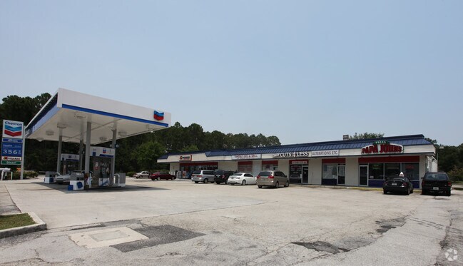
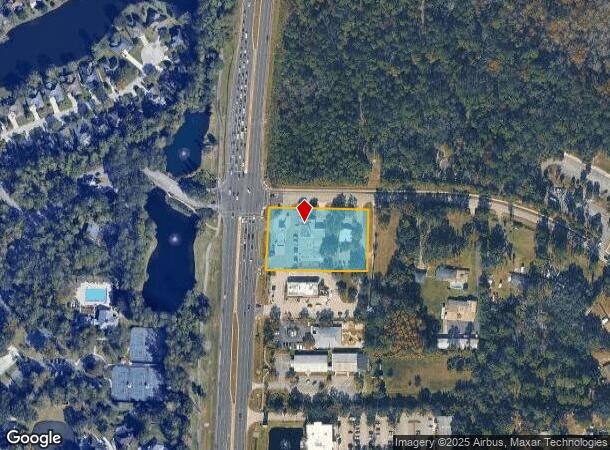
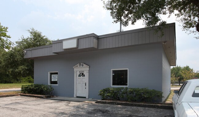
4305 Us Highway 17, Fleming Island, FL 32003
NEARBY LISTINGS FOR SALE OR LEASE
Property Detail
4305 Us Highway 17
Jacksonville, FL
O.P. Acs
28-04-26-013137-001-00
PT LOTS 18 & 19 BLK 3 O.P. ACS AS REC OR 4382 PG 978
Regionalshoppingcenterormallwithanchorstore
Clay
X
Florida
12109C0150K
18,19
2024
1.46 AC
2025
Orange Park/Clay County
030701
Jacksonville (Florida)
11,282 SF
DEMOGRAPHICS near 4305 Us Highway 17
1 Mile
3 Mile
5 Mile
2024 Total Population
4,262
26,350
100,357
2029 Population
4,618
28,499
109,985
Pop Growth 2024-2029
+ 8.35%
+ 8.16%
+ 9.59%
Average Age
47
44
43
2024 Total Households
1,630
10,119
38,110
HH Growth 2024-2029
+ 8.59%
+ 8.28%
+ 9.58%
Median Household Inc
$125,371
$111,827
$87,387
Avg Household Size
2.60
2.60
2.60
2024 Avg HH Vehicles
2.00
2.00
2.00
Median Home Value
$349,910
$363,331
$297,317
Median Year Built
1995
1996
1988
Nearby Places
Map Layers
Map Styles
 Street
 Aerial
- Restaurants
- Banks
- Shops
- Fitness
- Groceries
PUBLIC TRANSPORTATION
AIRPORT
Jacksonville International
DRIVE
WALK
Distance
Jacksonville International
47 min
33.3 mi
Freight Ports
Jacksonville Port
DRIVE
WALK
Distance
Jacksonville Port
37 min
21.8 mi
Nearby Properties
Address
Land Use
TOTAL SIZE
Lot Size
Zoning
Address
Land Use
TOTAL SIZE
Lot Size
Zoning
335,398 SF
31.66 AC
Address
Land Use
TOTAL SIZE
Lot Size
Zoning
539,095 SF
68.12 AC
Address
Land Use
TOTAL SIZE
Lot Size
Zoning
171,183 SF
11.37 AC
Address
Land Use
TOTAL SIZE
Lot Size
Zoning
125,572 SF
7.20 AC
Address
Land Use
TOTAL SIZE
Lot Size
Zoning
93,294 SF
30 AC
Address
Land Use
TOTAL SIZE
Lot Size
Zoning
89,070 SF
12.33 AC
PUD
Address
Land Use
TOTAL SIZE
Lot Size
Zoning
137,153 SF
25.85 AC
Address
Land Use
TOTAL SIZE
Lot Size
Zoning
112,498 SF
40 AC
Address
Land Use
TOTAL SIZE
Lot Size
Zoning
73,282 SF
12.51 AC
PUD
Address
Land Use
TOTAL SIZE
Lot Size
Zoning
84,047 SF
7.50 AC
BA
Address
Land Use
TOTAL SIZE
Lot Size
Zoning
89,674 SF
25 AC
RB
Address
Land Use
TOTAL SIZE
Lot Size
Zoning
203,600 SF
29.22 AC
PUD
Address
Land Use
TOTAL SIZE
Lot Size
Zoning
80,352 SF
0.97 AC
Address
Land Use
TOTAL SIZE
Lot Size
Zoning
80,613 SF
15.21 AC
PUD
Address
Land Use
TOTAL SIZE
Lot Size
Zoning
80,690 SF
9.18 AC
PUD
Address
Land Use
TOTAL SIZE
Lot Size
Zoning
41,188 SF
5.45 AC
Address
Land Use
TOTAL SIZE
Lot Size
Zoning
90,705 SF
3.74 AC
PCD
Address
Land Use
TOTAL SIZE
Lot Size
Zoning
Address
Land Use
TOTAL SIZE
Lot Size
Zoning
42,718 SF
3.56 AC
Address
Land Use
TOTAL SIZE
Lot Size
Zoning
112,752 SF
6.47 AC
BB-1
Address
Land Use
TOTAL SIZE
Lot Size
Zoning
65,959 SF
7.02 AC
PUD
Address
Land Use
TOTAL SIZE
Lot Size
Zoning
76,079 SF
10.12 AC
PS-5
Address
Land Use
TOTAL SIZE
Lot Size
Zoning
Address
Land Use
TOTAL SIZE
Lot Size
Zoning
80,251 SF
3.51 AC
Address
Land Use
TOTAL SIZE
Lot Size
Zoning
66,340 SF
10.10 AC
PS-1
Address
Land Use
TOTAL SIZE
Lot Size
Zoning
117,968 SF
14.42 AC
PUD
Address
Land Use
TOTAL SIZE
Lot Size
Zoning
54,124 SF
4.83 AC
PUD
Address
Land Use
TOTAL SIZE
Lot Size
Zoning
130,542 SF
16.18 AC
PUD
Address
Land Use
TOTAL SIZE
Lot Size
Zoning
68,727 SF
9.68 AC
Address
Land Use
TOTAL SIZE
Lot Size
Zoning
73,652 SF
11.75 AC
PUD
The World's #1 Commercial Real Estate Marketplace
Connect with us
© 2025 CoStar Group
The information above has been obtained from sources believed reliable. While we do not doubt its accuracy we have not verified it and make no guarantee, warranty or representation about it. It is your responsibility to independently confirm its accuracy and completeness. Any projections, opinions, assumptions, or estimates used are for example only and do not represent the current or future performance of the property. The value of this transaction to you depends on tax and other factors which should be evaluated by your tax, financial, and legal advisors. You and your advisors should conduct a careful, independent investigation of the property to determine to your satisfaction the suitability of the property for your needs.