Property Record
4306 Bennett Memorial Rd, Durham, NC 27705


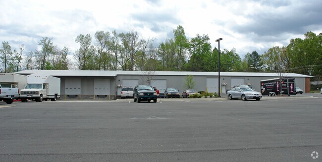
Property Detail
4306 Bennett Memorial Rd
175235
PROP-BASS-GOODWIN/TR#02 PL:000148-000137
Miscellaneous
DURHAM
IL
North Carolina
B and X Area of moderate flood hazard, usually the area between the limits of the 100-year and 500-year floods.
1.85 AC
2025
South Durham
2025
Raleigh/Durham
001713
Durham-Chapel Hill, NC
16,800 SF
NEARBY LISTINGS FOR SALE OR LEASE
DEMOGRAPHICS near 4306 Bennett Memorial Rd
1 mile
3 mile
5 mile
2025 Total Population
5,429
40,708
125,396
2030 Population
5,703
42,767
132,530
Pop Growth 2025-2030
+ 5.05%
+ 5.06%
+ 5.69%
Average Age
42
38
38
2025 Total Households
2,467
17,769
54,373
HH Growth 2025-2030
+ 5.23%
+ 5.70%
+ 6.18%
Median Household Inc
$120,909
$71,128
$74,550
Avg Household Size
2.20
2.10
2.10
2025 Avg HH Vehicles
2.00
2.00
2.00
Median Home Value
$396,853
$464,328
$459,523
Median Year Built
1986
1988
1986
Nearby Places
Map Layers
Map Styles
 Street
 Aerial
Transit
 Traffic
 Biking
Places
Listings with unknown addresses are not visible on the map
- Restaurants
- Banks
- Shops
- Fitness
- Groceries
PUBLIC TRANSPORTATION
AIRPORT
Raleigh-Durham International
Drive
Walk
Distance
Raleigh-Durham International
31 min
19.8 mi
Nearby Properties
Address
Land Use
TOTAL SIZE
Lot Size
Zoning
Address
Land Use
TOTAL SIZE
Lot Size
Zoning
8,478 SF
676.09 AC
UC
Address
Land Use
TOTAL SIZE
Lot Size
Zoning
26,512 SF
6.40 AC
CD-C
Address
Land Use
TOTAL SIZE
Lot Size
Zoning
758,666 SF
99.64 AC
PDR 2.000
Address
Land Use
TOTAL SIZE
Lot Size
Zoning
24,741 SF
5.67 AC
CD-S1
Address
Land Use
TOTAL SIZE
Lot Size
Zoning
416,469 SF
3.85 AC
MU(D)
Address
Land Use
TOTAL SIZE
Lot Size
Zoning
3.20 AC
CD-S1
Address
Land Use
TOTAL SIZE
Lot Size
Zoning
812,903 SF
9.31 AC
UC
Address
Land Use
TOTAL SIZE
Lot Size
Zoning
90,416 SF
3.87 AC
CD-S1
Address
Land Use
TOTAL SIZE
Lot Size
Zoning
132,520 SF
15.94 AC
RU-M(D)
Address
Land Use
TOTAL SIZE
Lot Size
Zoning
12,236 SF
43.44 AC
RU-M
Address
Land Use
TOTAL SIZE
Lot Size
Zoning
12,440 SF
36.51 AC
PDR 2.000
Address
Land Use
TOTAL SIZE
Lot Size
Zoning
441,868 SF
6.11 AC
MU(D)
Address
Land Use
TOTAL SIZE
Lot Size
Zoning
234,754 SF
4.85 AC
UC
Address
Land Use
TOTAL SIZE
Lot Size
Zoning
903.08 AC
RR,RS-20,U
Address
Land Use
TOTAL SIZE
Lot Size
Zoning
485,295 SF
27.35 AC
RS-8
Address
Land Use
TOTAL SIZE
Lot Size
Zoning
296,580 SF
2.53 AC
MU(D)
Address
Land Use
TOTAL SIZE
Lot Size
Zoning
256,975 SF
7.42 AC
CD-C
Address
Land Use
TOTAL SIZE
Lot Size
Zoning
236,319 SF
17.04 AC
UC(D)
Address
Land Use
TOTAL SIZE
Lot Size
Zoning
9,126 SF
20.02 AC
RU-M
Address
Land Use
TOTAL SIZE
Lot Size
Zoning
9,318 SF
19.27 AC
RS-M
Address
Land Use
TOTAL SIZE
Lot Size
Zoning
1.19 AC
MU(D)
Address
Land Use
TOTAL SIZE
Lot Size
Zoning
153,300 SF
0.99 AC
MU(D)
Address
Land Use
TOTAL SIZE
Lot Size
Zoning
297,910 SF
39.63 AC
RS-20
Address
Land Use
TOTAL SIZE
Lot Size
Zoning
13,432 SF
21.46 AC
RU-M
Address
Land Use
TOTAL SIZE
Lot Size
Zoning
12,468 SF
13.33 AC
RU-M(D)
Address
Land Use
TOTAL SIZE
Lot Size
Zoning
20,508 SF
15.82 AC
RS-M
Address
Land Use
TOTAL SIZE
Lot Size
Zoning
36,380 SF
4.02 AC
MU(D)
Address
Land Use
TOTAL SIZE
Lot Size
Zoning
6,822 SF
24.64 AC
PDR 2.000
Address
Land Use
TOTAL SIZE
Lot Size
Zoning
130,550 SF
4.07 AC
I
Address
Land Use
TOTAL SIZE
Lot Size
Zoning
233,478 SF
10.60 AC
OI
The World's #1 Commercial Real Estate Marketplace
Connect with us
© 2026 CoStar Group
The information above has been obtained from sources believed reliable. While we do not doubt its accuracy we have not verified it and make no guarantee, warranty or representation about it. It is your responsibility to independently confirm its accuracy and completeness. Any projections, opinions, assumptions, or estimates used are for example only and do not represent the current or future performance of the property. The value of this transaction to you depends on tax and other factors which should be evaluated by your tax, financial, and legal advisors. You and your advisors should conduct a careful, independent investigation of the property to determine to your satisfaction the suitability of the property for your needs.