Property Record
4307 Friendship Rd, Buford, GA 30519

NEARBY LISTINGS FOR SALE OR LEASE
-
-
View all Buford listings for sale on LoopNet.com
Property Detail
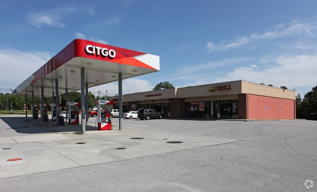
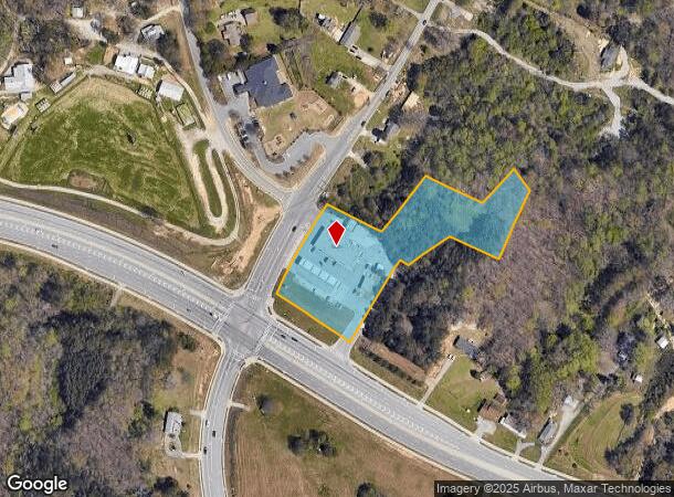
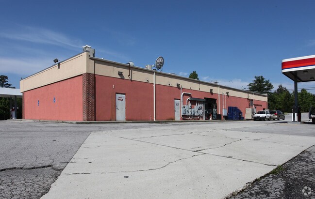
4307 Friendship Rd
Gainesville, GA
Friendship/Hog Mtn Commercial
08-00154-00-015
4305 FRIENDSHIP ROAD
Carwashautomated
Hall
X
Georgia
13139C0293H
0
2025
3.47 AC
2025
Gainesville/Hall Cnty
001605
Atlanta
828 SF
DEMOGRAPHICS near 4307 Friendship Rd
1 Mile
3 Mile
5 Mile
2024 Total Population
1,615
34,634
98,746
2029 Population
1,776
37,866
107,143
Pop Growth 2024-2029
+ 9.97%
+ 9.33%
+ 8.50%
Average Age
40
39
39
2024 Total Households
533
11,344
32,961
HH Growth 2024-2029
+ 9.94%
+ 9.54%
+ 8.78%
Median Household Inc
$86,093
$94,556
$88,953
Avg Household Size
3.00
3.00
2.90
2024 Avg HH Vehicles
2.00
2.00
2.00
Median Home Value
$318,421
$331,894
$339,726
Median Year Built
1998
2003
2003
Nearby Places
Map Layers
Map Styles
 Street
 Aerial
- Restaurants
- Banks
- Shops
- Fitness
- Groceries
Nearby Properties
Address
Land Use
TOTAL SIZE
Lot Size
Zoning
Address
Land Use
TOTAL SIZE
Lot Size
Zoning
285,000 SF
97.06 AC
M-I
Address
Land Use
TOTAL SIZE
Lot Size
Zoning
815,563 SF
58.80 AC
M-I
Address
Land Use
TOTAL SIZE
Lot Size
Zoning
101,632 SF
78.33 AC
M-I
Address
Land Use
TOTAL SIZE
Lot Size
Zoning
273,101 SF
126.33 AC
PRD
Address
Land Use
TOTAL SIZE
Lot Size
Zoning
213,532 SF
44.32 AC
M-I
Address
Land Use
TOTAL SIZE
Lot Size
Zoning
224,093 SF
33.94 AC
M-I
Address
Land Use
TOTAL SIZE
Lot Size
Zoning
264,600 SF
10.27 AC
M1
Address
Land Use
TOTAL SIZE
Lot Size
Zoning
143,000 SF
41.30 AC
M-I
Address
Land Use
TOTAL SIZE
Lot Size
Zoning
458,256 SF
26.39 AC
M-I
Address
Land Use
TOTAL SIZE
Lot Size
Zoning
72,304 SF
83.10 AC
R100
Address
Land Use
TOTAL SIZE
Lot Size
Zoning
261,368 SF
5.80 AC
M-I
Address
Land Use
TOTAL SIZE
Lot Size
Zoning
225,851 SF
34.35 AC
R75
Address
Land Use
TOTAL SIZE
Lot Size
Zoning
300,000 SF
23.03 AC
M-II
Address
Land Use
TOTAL SIZE
Lot Size
Zoning
350,084 SF
40 AC
M1
Address
Land Use
TOTAL SIZE
Lot Size
Zoning
194,748 SF
1.09 AC
PCD
Address
Land Use
TOTAL SIZE
Lot Size
Zoning
162,013 SF
20.23 AC
RA200
Address
Land Use
TOTAL SIZE
Lot Size
Zoning
303,526 SF
19.77 AC
M1
Address
Land Use
TOTAL SIZE
Lot Size
Zoning
158,900 SF
13.94 AC
M-II
Address
Land Use
TOTAL SIZE
Lot Size
Zoning
250,444 SF
32.04 AC
M1
Address
Land Use
TOTAL SIZE
Lot Size
Zoning
130,211 SF
14.03 AC
C1
Address
Land Use
TOTAL SIZE
Lot Size
Zoning
18,408 SF
15.50 AC
L-I
Address
Land Use
TOTAL SIZE
Lot Size
Zoning
236,184 SF
26.58 AC
M1
Address
Land Use
TOTAL SIZE
Lot Size
Zoning
96.39 AC
M1
Address
Land Use
TOTAL SIZE
Lot Size
Zoning
125,400 SF
21.87 AC
MUNI
Address
Land Use
TOTAL SIZE
Lot Size
Zoning
5,896 SF
40.06 AC
RA200
Address
Land Use
TOTAL SIZE
Lot Size
Zoning
31,094 SF
126.02 AC
RA200
Address
Land Use
TOTAL SIZE
Lot Size
Zoning
164,704 SF
10.26 AC
C1
Address
Land Use
TOTAL SIZE
Lot Size
Zoning
68,974 SF
9.81 AC
H-B
Address
Land Use
TOTAL SIZE
Lot Size
Zoning
76.34 AC
M-1
Address
Land Use
TOTAL SIZE
Lot Size
Zoning
50,456 SF
58.60 AC
INST
The World's #1 Commercial Real Estate Marketplace
Connect with us
© 2025 CoStar Group
The information above has been obtained from sources believed reliable. While we do not doubt its accuracy we have not verified it and make no guarantee, warranty or representation about it. It is your responsibility to independently confirm its accuracy and completeness. Any projections, opinions, assumptions, or estimates used are for example only and do not represent the current or future performance of the property. The value of this transaction to you depends on tax and other factors which should be evaluated by your tax, financial, and legal advisors. You and your advisors should conduct a careful, independent investigation of the property to determine to your satisfaction the suitability of the property for your needs.