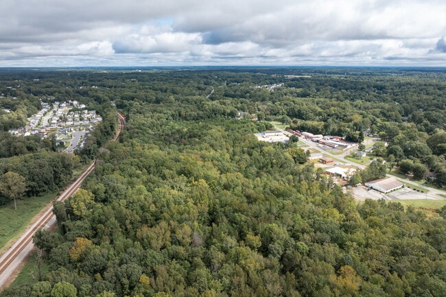
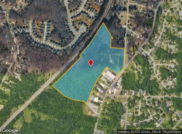
Property Record
4307 Southern Webbing Mill Rd, Greensboro, NC 27405
This Property Is For Sale
NEARBY LISTINGS FOR SALE OR LEASE
Property Detail
4307 Southern Webbing Mill Rd
Greensboro/Winston-Salem
Allisons Lndg Ph 01 & 02
Greensboro-High Point, NC
Guilford
0045335
North Carolina
Residentialnec
25.15 AC
AE
NE Guilford County
3710787600J
DEMOGRAPHICS near 4307 Southern Webbing Mill Rd
1 Mile
3 Mile
5 Mile
2024 Total Population
9,175
56,541
130,097
2029 Population
9,196
56,654
130,215
Pop Growth 2024-2029
+ 0.23%
+ 0.20%
+ 0.09%
Average Age
36
38
38
2024 Total Households
3,377
22,425
51,291
HH Growth 2024-2029
+ 0.15%
+ 0.12%
+ 0.10%
Median Household Inc
$45,885
$49,173
$53,889
Avg Household Size
2.60
2.40
2.30
2024 Avg HH Vehicles
2.00
2.00
2.00
Median Home Value
$129,554
$165,292
$188,162
Median Year Built
1988
1985
1980
Nearby Places
Map Layers
Map Styles
 Street
 Aerial
- Restaurants
- Banks
- Shops
- Fitness
- Groceries
PUBLIC TRANSPORTATION
COMMUTER RAIL
Greensboro Station (Piedmont - North Carolina by Train (NC Train))
DRIVE
WALK
Distance
Greensboro Station (Piedmont - North Carolina by Train (NC Train))
9 min
4.9 mi
AIRPORT
Piedmont Triad International
DRIVE
WALK
Distance
Piedmont Triad International
26 min
15.0 mi
Nearby Properties
Address
Land Use
TOTAL SIZE
Lot Size
Zoning
Address
Land Use
TOTAL SIZE
Lot Size
Zoning
646,229 SF
25.47 AC
LI
Address
Land Use
TOTAL SIZE
Lot Size
Zoning
223,891 SF
10.53 AC
PUD
Address
Land Use
TOTAL SIZE
Lot Size
Zoning
281,337 SF
20.64 AC
PUD
Address
Land Use
TOTAL SIZE
Lot Size
Zoning
252,109 SF
8.83 AC
PUD
Address
Land Use
TOTAL SIZE
Lot Size
Zoning
336,133 SF
23.93 AC
CU-RM-12
Address
Land Use
TOTAL SIZE
Lot Size
Zoning
171,358 SF
11.91 AC
PUD
Address
Land Use
TOTAL SIZE
Lot Size
Zoning
112,050 SF
9.24 AC
LI
Address
Land Use
TOTAL SIZE
Lot Size
Zoning
504,000 SF
42.01 AC
HI
Address
Land Use
TOTAL SIZE
Lot Size
Zoning
584,848 SF
32.91 AC
HI
Address
Land Use
TOTAL SIZE
Lot Size
Zoning
270,848 SF
18.28 AC
RM-18
Address
Land Use
TOTAL SIZE
Lot Size
Zoning
214,583 SF
20.64 AC
C-H
Address
Land Use
TOTAL SIZE
Lot Size
Zoning
259,434 SF
23.69 AC
RM-12
Address
Land Use
TOTAL SIZE
Lot Size
Zoning
38,940 SF
19.33 AC
R-3
Address
Land Use
TOTAL SIZE
Lot Size
Zoning
168,798 SF
15.45 AC
RM-12
Address
Land Use
TOTAL SIZE
Lot Size
Zoning
236,995 SF
14.09 AC
RM-18
Address
Land Use
TOTAL SIZE
Lot Size
Zoning
204,260 SF
11.83 AC
RM-18
Address
Land Use
TOTAL SIZE
Lot Size
Zoning
99,926 SF
8.13 AC
O
Address
Land Use
TOTAL SIZE
Lot Size
Zoning
189,979 SF
44.76 AC
PI
Address
Land Use
TOTAL SIZE
Lot Size
Zoning
191,654 SF
11.31 AC
RM-12
Address
Land Use
TOTAL SIZE
Lot Size
Zoning
305,428 SF
13.72 AC
PUD
Address
Land Use
TOTAL SIZE
Lot Size
Zoning
119,780 SF
8.50 AC
PUD
Address
Land Use
TOTAL SIZE
Lot Size
Zoning
127,976 SF
40.04 AC
R-3
Address
Land Use
TOTAL SIZE
Lot Size
Zoning
167,490 SF
11.51 AC
C-H
Address
Land Use
TOTAL SIZE
Lot Size
Zoning
65,265 SF
14.08 AC
LI
Address
Land Use
TOTAL SIZE
Lot Size
Zoning
103,218 SF
11.65 AC
RM-12
Address
Land Use
TOTAL SIZE
Lot Size
Zoning
257,713 SF
24.07 AC
HI
Address
Land Use
TOTAL SIZE
Lot Size
Zoning
110,908 SF
10.10 AC
C-H
Address
Land Use
TOTAL SIZE
Lot Size
Zoning
243,880 SF
29.56 AC
HI
Address
Land Use
TOTAL SIZE
Lot Size
Zoning
18.71 AC
R-3
Address
Land Use
TOTAL SIZE
Lot Size
Zoning
137,573 SF
14.01 AC
C-H
The World's #1 Commercial Real Estate Marketplace
Connect with us
© 2026 CoStar Group
The information above has been obtained from sources believed reliable. While we do not doubt its accuracy we have not verified it and make no guarantee, warranty or representation about it. It is your responsibility to independently confirm its accuracy and completeness. Any projections, opinions, assumptions, or estimates used are for example only and do not represent the current or future performance of the property. The value of this transaction to you depends on tax and other factors which should be evaluated by your tax, financial, and legal advisors. You and your advisors should conduct a careful, independent investigation of the property to determine to your satisfaction the suitability of the property for your needs.