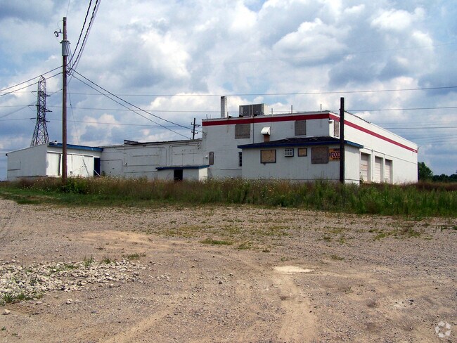
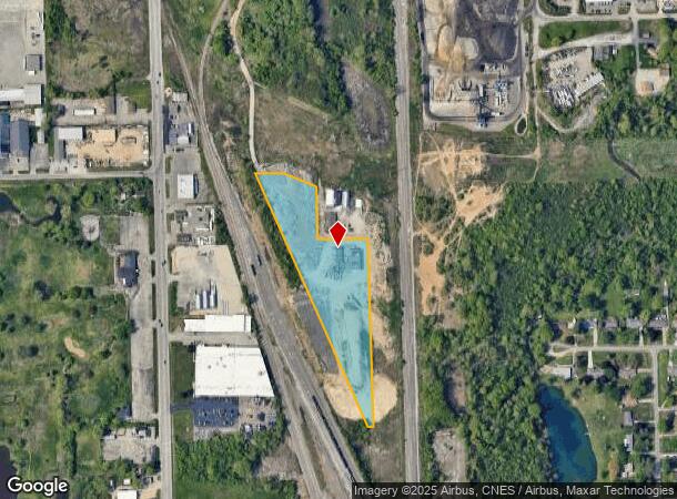
Property Record
4309 N Dort Hwy, Flint, MI 48505

NEARBY LISTINGS FOR SALE OR LEASE
Property Detail
4309 N Dort Hwy
59-33-300-010
ALL THAT PART OF NW 1/4 OF SW 1/4 LYING E OF P M R R RIGHT OF WAY EXCEPT E 13 RDS ALSO EXCEPT WLY 132 FT ALSO EXCEPT A PARCEL
Commercialnec
Genesee
X
Michigan
26049C0309D
8.49 AC
2024
Flint
2025
Detroit
000400
Flint, MI
10,445 SF
DEMOGRAPHICS near 4309 N Dort Hwy
1 Mile
3 Mile
5 Mile
2024 Total Population
3,379
53,441
120,961
2029 Population
3,291
52,420
119,251
Pop Growth 2024-2029
(2.60%)
(1.91%)
(1.41%)
Average Age
39
39
39
2024 Total Households
1,382
22,103
50,399
HH Growth 2024-2029
(2.75%)
(1.98%)
(1.44%)
Median Household Inc
$43,573
$43,731
$49,061
Avg Household Size
2.40
2.30
2.30
2024 Avg HH Vehicles
2.00
2.00
2.00
Median Home Value
$87,670
$122,279
$136,761
Median Year Built
1959
1965
1965
Nearby Places
Map Layers
Map Styles
 Street
 Aerial
- Restaurants
- Banks
- Shops
- Fitness
- Groceries
PUBLIC TRANSPORTATION
AIRPORT
Bishop International
DRIVE
WALK
Distance
Bishop International
13 min
5.4 mi
SALE & LEASE HISTORY
LISTING DATE
SALE/LEASE

Sep 24, 2016
For Sale
Nearby Properties
Address
Land Use
TOTAL SIZE
Lot Size
Zoning
Address
Land Use
TOTAL SIZE
Lot Size
Zoning
507,562 SF
39.37 AC
HDM
Address
Land Use
TOTAL SIZE
Lot Size
Zoning
Address
Land Use
TOTAL SIZE
Lot Size
Zoning
51.26 AC
HDM
Address
Land Use
TOTAL SIZE
Lot Size
Zoning
155,220 SF
33.46 AC
GC
Address
Land Use
TOTAL SIZE
Lot Size
Zoning
33.65 AC
MDM
Address
Land Use
TOTAL SIZE
Lot Size
Zoning
210,684 SF
27.06 AC
GC
Address
Land Use
TOTAL SIZE
Lot Size
Zoning
612,305 SF
116.49 AC
I-2
Address
Land Use
TOTAL SIZE
Lot Size
Zoning
157,756 SF
21.17 AC
MDM
Address
Land Use
TOTAL SIZE
Lot Size
Zoning
78,517 SF
16.80 AC
GC
Address
Land Use
TOTAL SIZE
Lot Size
Zoning
674,049 SF
24.02 AC
I-2
Address
Land Use
TOTAL SIZE
Lot Size
Zoning
227,755 SF
32.27 AC
C-2
Address
Land Use
TOTAL SIZE
Lot Size
Zoning
88,701 SF
10.27 AC
GC
Address
Land Use
TOTAL SIZE
Lot Size
Zoning
137,169 SF
18.50 AC
GC
Address
Land Use
TOTAL SIZE
Lot Size
Zoning
100,000 SF
Address
Land Use
TOTAL SIZE
Lot Size
Zoning
58,648 SF
5.80 AC
OS
Address
Land Use
TOTAL SIZE
Lot Size
Zoning
60,613 SF
12.91 AC
RO
Address
Land Use
TOTAL SIZE
Lot Size
Zoning
9.88 AC
HDM
Address
Land Use
TOTAL SIZE
Lot Size
Zoning
118,750 SF
21.26 AC
C-3A
Address
Land Use
TOTAL SIZE
Lot Size
Zoning
246,759 SF
19.03 AC
CC
Address
Land Use
TOTAL SIZE
Lot Size
Zoning
24.38 AC
RM
Address
Land Use
TOTAL SIZE
Lot Size
Zoning
91,726 SF
7.28 AC
HDM
Address
Land Use
TOTAL SIZE
Lot Size
Zoning
24,670 SF
9.62 AC
GC
Address
Land Use
TOTAL SIZE
Lot Size
Zoning
49,582 SF
25.15 AC
HRM
Address
Land Use
TOTAL SIZE
Lot Size
Zoning
364,289 SF
24.80 AC
GN-1
Address
Land Use
TOTAL SIZE
Lot Size
Zoning
41,508 SF
5.27 AC
OS
Address
Land Use
TOTAL SIZE
Lot Size
Zoning
236,340 SF
25.17 AC
CE
Address
Land Use
TOTAL SIZE
Lot Size
Zoning
11.22 AC
RM
Address
Land Use
TOTAL SIZE
Lot Size
Zoning
2,321 SF
18.59 AC
M-1
Address
Land Use
TOTAL SIZE
Lot Size
Zoning
2,829 SF
75.78 AC
RMH
Address
Land Use
TOTAL SIZE
Lot Size
Zoning
61,102 SF
4.40 AC
B-2
The World's #1 Commercial Real Estate Marketplace
Connect with us
© 2025 CoStar Group
The information above has been obtained from sources believed reliable. While we do not doubt its accuracy we have not verified it and make no guarantee, warranty or representation about it. It is your responsibility to independently confirm its accuracy and completeness. Any projections, opinions, assumptions, or estimates used are for example only and do not represent the current or future performance of the property. The value of this transaction to you depends on tax and other factors which should be evaluated by your tax, financial, and legal advisors. You and your advisors should conduct a careful, independent investigation of the property to determine to your satisfaction the suitability of the property for your needs.