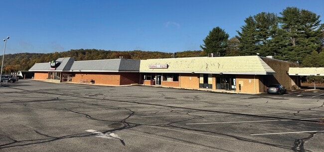
Property Record
431 County Road 513, Califon, NJ 07830


Current Lease Availabilities
NEARBY LISTINGS FOR SALE OR LEASE
-
-
View all Califon listings for lease on LoopNet.com
Property Detail
431 County Road 513
19-00038-0000-00028
ADDITIONAL LOTS: 28.01
Vacantlandnec
Hunterdon
X
New Jersey
34019C0126F
28
2024
3.99 AC
2025
Route 78 West
010802
Northern New Jersey
32,049 SF
Newark, NJ-PA
DEMOGRAPHICS near 431 County Road 513
1 Mile
3 Mile
5 Mile
2024 Total Population
1,589
6,897
21,531
2029 Population
1,596
6,925
21,612
Pop Growth 2024-2029
+ 0.44%
+ 0.41%
+ 0.38%
Average Age
44
44
43
2024 Total Households
616
2,544
7,717
HH Growth 2024-2029
+ 0.49%
+ 0.51%
+ 0.49%
Median Household Inc
$125,117
$140,317
$140,957
Avg Household Size
2.60
2.60
2.60
2024 Avg HH Vehicles
2.00
2.00
2.00
Median Home Value
$370,945
$485,581
$495,297
Median Year Built
1965
1972
1974
Nearby Places
Map Layers
Map Styles
 Street
 Aerial
- Restaurants
- Banks
- Shops
- Fitness
- Groceries
PUBLIC TRANSPORTATION
COMMUTER RAIL
High Bridge (Raritan Valley Line - NJ Transit Commuter Rail (NJ Transit))
DRIVE
WALK
Distance
High Bridge (Raritan Valley Line - NJ Transit Commuter Rail (NJ Transit))
8 min
5.5 mi
Annandale (Raritan Valley Line - NJ Transit Commuter Rail (NJ Transit))
DRIVE
WALK
Distance
Annandale (Raritan Valley Line - NJ Transit Commuter Rail (NJ Transit))
15 min
7.5 mi
Freight Ports
New York Container Terminal
DRIVE
WALK
Distance
New York Container Terminal
70 min
48.6 mi
Nearby Properties
Address
Land Use
TOTAL SIZE
Lot Size
Zoning
Address
Land Use
TOTAL SIZE
Lot Size
Zoning
56.97 AC
R3
Address
Land Use
TOTAL SIZE
Lot Size
Zoning
59,942 SF
20.09 AC
R-5
Address
Land Use
TOTAL SIZE
Lot Size
Zoning
26.52 AC
RC
Address
Land Use
TOTAL SIZE
Lot Size
Zoning
3,823 SF
165 AC
RC
Address
Land Use
TOTAL SIZE
Lot Size
Zoning
2,544 SF
562.37 AC
RC
Address
Land Use
TOTAL SIZE
Lot Size
Zoning
5.70 AC
R-5
Address
Land Use
TOTAL SIZE
Lot Size
Zoning
16,580 SF
25.53 AC
RC
Address
Land Use
TOTAL SIZE
Lot Size
Zoning
64.75 AC
R-5
Address
Land Use
TOTAL SIZE
Lot Size
Zoning
66.80 AC
RC
Address
Land Use
TOTAL SIZE
Lot Size
Zoning
19,905 SF
1.92 AC
R-3
Address
Land Use
TOTAL SIZE
Lot Size
Zoning
2,368 SF
227.39 AC
R3
Address
Land Use
TOTAL SIZE
Lot Size
Zoning
1,520 SF
302.94 AC
RC
Address
Land Use
TOTAL SIZE
Lot Size
Zoning
44,502 SF
16.86 AC
I
Address
Land Use
TOTAL SIZE
Lot Size
Zoning
6,080 SF
37.09 AC
RC
Address
Land Use
TOTAL SIZE
Lot Size
Zoning
28,530 SF
3.09 AC
HB
Address
Land Use
TOTAL SIZE
Lot Size
Zoning
750 SF
250.02 AC
RC
Address
Land Use
TOTAL SIZE
Lot Size
Zoning
19,209 SF
2.25 AC
HL
Address
Land Use
TOTAL SIZE
Lot Size
Zoning
12,737 SF
4.29 AC
HL
Address
Land Use
TOTAL SIZE
Lot Size
Zoning
2,738 SF
2.13 AC
HB
Address
Land Use
TOTAL SIZE
Lot Size
Zoning
9,818 SF
4 AC
HL
Address
Land Use
TOTAL SIZE
Lot Size
Zoning
5,684 SF
5.08 AC
R1.5
Address
Land Use
TOTAL SIZE
Lot Size
Zoning
13,224 SF
2.45 AC
R-3
Address
Land Use
TOTAL SIZE
Lot Size
Zoning
8,549 SF
60.68 AC
HL
Address
Land Use
TOTAL SIZE
Lot Size
Zoning
Address
Land Use
TOTAL SIZE
Lot Size
Zoning
7,719 SF
1.34 AC
RC
Address
Land Use
TOTAL SIZE
Lot Size
Zoning
6,548 SF
3 AC
HL
Address
Land Use
TOTAL SIZE
Lot Size
Zoning
4,854 SF
2 AC
R-5
Address
Land Use
TOTAL SIZE
Lot Size
Zoning
6,524 SF
5.06 AC
R1.5
Address
Land Use
TOTAL SIZE
Lot Size
Zoning
6,633 SF
1 AC
HL
The World's #1 Commercial Real Estate Marketplace
Connect with us
© 2025 CoStar Group
The information above has been obtained from sources believed reliable. While we do not doubt its accuracy we have not verified it and make no guarantee, warranty or representation about it. It is your responsibility to independently confirm its accuracy and completeness. Any projections, opinions, assumptions, or estimates used are for example only and do not represent the current or future performance of the property. The value of this transaction to you depends on tax and other factors which should be evaluated by your tax, financial, and legal advisors. You and your advisors should conduct a careful, independent investigation of the property to determine to your satisfaction the suitability of the property for your needs.