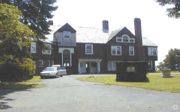
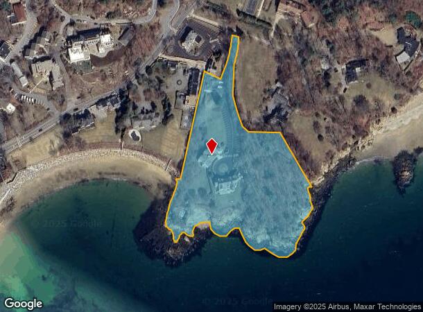
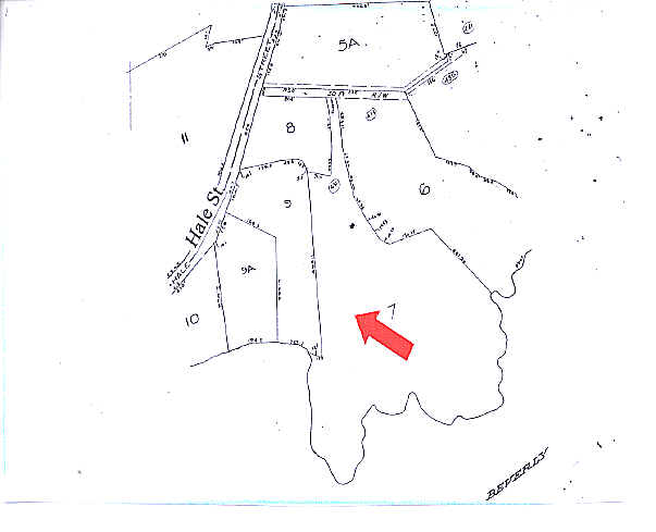
Property Record
431 Hale St, Beverly, MA 01915
NEARBY LISTINGS FOR SALE OR LEASE
-
-
View all Beverly listings for sale on LoopNet.com
Property Detail
431 Hale St
Publicschool
Essex
VE
Massachusetts
25009C0437G
6.15 AC
0
Danvers/Beverly
2025
Boston
217602
Boston-Cambridge-Newton, MA-NH
11,273 SF
BEVE M:0016 B:0007 L:
DEMOGRAPHICS near 431 Hale St
1 Mile
3 Mile
5 Mile
2024 Total Population
1,377
34,218
122,129
2029 Population
1,355
34,030
121,318
Pop Growth 2024-2029
(1.60%)
(0.55%)
(0.66%)
Average Age
30
40
41
2024 Total Households
183
13,414
49,601
HH Growth 2024-2029
(2.73%)
(0.61%)
(0.82%)
Median Household Inc
$207,368
$91,707
$93,361
Avg Household Size
2.40
2.20
2.30
2024 Avg HH Vehicles
3.00
2.00
2.00
Median Home Value
$977,940
$627,323
$630,220
Median Year Built
1969
1957
1951
Nearby Places
Map Layers
Map Styles
 Street
 Aerial
- Restaurants
- Banks
- Shops
- Fitness
- Groceries
PUBLIC TRANSPORTATION
COMMUTER RAIL
Beverly Farms (Newburyport/Rockport Line - Massachusetts Bay Transportation Authority Commuter Rail (Purple Line))
DRIVE
WALK
Distance
Beverly Farms (Newburyport/Rockport Line - Massachusetts Bay Transportation Authority Commuter Rail (Purple Line))
4 min
1.6 mi
Montserrat (Newburyport/Rockport Line - Massachusetts Bay Transportation Authority Commuter Rail (Purple Line))
DRIVE
WALK
Distance
Montserrat (Newburyport/Rockport Line - Massachusetts Bay Transportation Authority Commuter Rail (Purple Line))
6 min
2.5 mi
AIRPORT
General Edward Lawrence Logan International
DRIVE
WALK
Distance
General Edward Lawrence Logan International
36 min
19.4 mi
Freight Ports
Port of Boston
DRIVE
WALK
Distance
Port of Boston
42 min
22.1 mi
Nearby Properties
Address
Land Use
TOTAL SIZE
Lot Size
Zoning
Address
Land Use
TOTAL SIZE
Lot Size
Zoning
48.89 AC
IG
Address
Land Use
TOTAL SIZE
Lot Size
Zoning
496,607 SF
71.29 AC
R45
Address
Land Use
TOTAL SIZE
Lot Size
Zoning
267,051 SF
41.08 AC
R10
Address
Land Use
TOTAL SIZE
Lot Size
Zoning
228,295 SF
12.50 AC
RMD
Address
Land Use
TOTAL SIZE
Lot Size
Zoning
231,509 SF
17.71 AC
R10
Address
Land Use
TOTAL SIZE
Lot Size
Zoning
138,311 SF
56.04 AC
R45
Address
Land Use
TOTAL SIZE
Lot Size
Zoning
170,652 SF
23.73 AC
HD
Address
Land Use
TOTAL SIZE
Lot Size
Zoning
118,110 SF
0.67 AC
CC
Address
Land Use
TOTAL SIZE
Lot Size
Zoning
10,464 SF
237.02 AC
Address
Land Use
TOTAL SIZE
Lot Size
Zoning
14.50 AC
R1
Address
Land Use
TOTAL SIZE
Lot Size
Zoning
108,259 SF
17.30 AC
R45
Address
Land Use
TOTAL SIZE
Lot Size
Zoning
112,023 SF
0.74 AC
CC
Address
Land Use
TOTAL SIZE
Lot Size
Zoning
91,168 SF
2.09 AC
CC
Address
Land Use
TOTAL SIZE
Lot Size
Zoning
42.30 AC
I
Address
Land Use
TOTAL SIZE
Lot Size
Zoning
64,845 SF
6.50 AC
RMD
Address
Land Use
TOTAL SIZE
Lot Size
Zoning
84,871 SF
0.96 AC
CC
Address
Land Use
TOTAL SIZE
Lot Size
Zoning
75,348 SF
1.35 AC
RMD
Address
Land Use
TOTAL SIZE
Lot Size
Zoning
207,095 SF
IR
Address
Land Use
TOTAL SIZE
Lot Size
Zoning
112,034 SF
1.06 AC
CC
Address
Land Use
TOTAL SIZE
Lot Size
Zoning
91,968 SF
2.20 AC
R1
Address
Land Use
TOTAL SIZE
Lot Size
Zoning
44,966 SF
86.67 AC
R45
Address
Land Use
TOTAL SIZE
Lot Size
Zoning
69,351 SF
0.49 AC
CC
Address
Land Use
TOTAL SIZE
Lot Size
Zoning
99,412 SF
5.55 AC
C
Address
Land Use
TOTAL SIZE
Lot Size
Zoning
122,105 SF
12.96 AC
R10
Address
Land Use
TOTAL SIZE
Lot Size
Zoning
79,964 SF
7.78 AC
R15
Address
Land Use
TOTAL SIZE
Lot Size
Zoning
50,742 SF
6.68 AC
RMD
Address
Land Use
TOTAL SIZE
Lot Size
Zoning
68,740 SF
6.50 AC
IR
Address
Land Use
TOTAL SIZE
Lot Size
Zoning
140,215 SF
4.89 AC
RMD
Address
Land Use
TOTAL SIZE
Lot Size
Zoning
156,675 SF
IR
Address
Land Use
TOTAL SIZE
Lot Size
Zoning
23,931 SF
3.16 AC
R90
The World's #1 Commercial Real Estate Marketplace
Connect with us
© 2026 CoStar Group
The information above has been obtained from sources believed reliable. While we do not doubt its accuracy we have not verified it and make no guarantee, warranty or representation about it. It is your responsibility to independently confirm its accuracy and completeness. Any projections, opinions, assumptions, or estimates used are for example only and do not represent the current or future performance of the property. The value of this transaction to you depends on tax and other factors which should be evaluated by your tax, financial, and legal advisors. You and your advisors should conduct a careful, independent investigation of the property to determine to your satisfaction the suitability of the property for your needs.