Property Record
431 Mantoloking Rd, Brick, NJ 08723

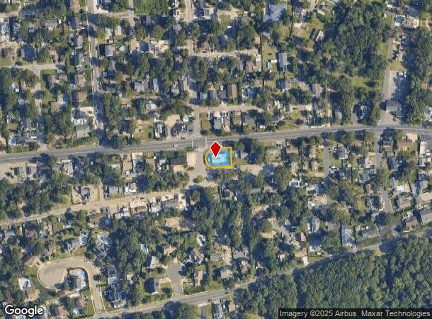
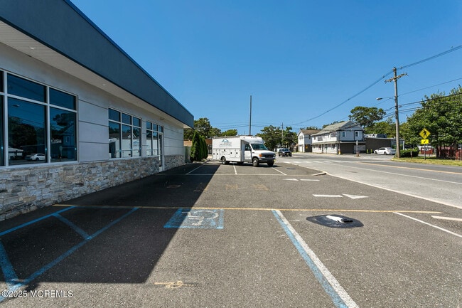
This Property Is For Sale
NEARBY LISTINGS FOR SALE OR LEASE
Property Detail
431 Mantoloking Rd
New York-Jersey City-White Plains, NY-NJ
Southern Sec Vanda Woods & Cap
07-00188-0000-00001
100X80 2,3,4
Commercialnec
Ocean
X
New Jersey
34029C0211F
1
2024
0.18 AC
2025
Ocean County
713800
Northern New Jersey
1,770 SF
DEMOGRAPHICS near 431 Mantoloking Rd
1 Mile
3 Mile
5 Mile
2024 Total Population
5,281
61,664
138,465
2029 Population
5,678
66,285
148,865
Pop Growth 2024-2029
+ 7.52%
+ 7.49%
+ 7.51%
Average Age
42
42
45
2024 Total Households
2,095
24,121
57,783
HH Growth 2024-2029
+ 7.16%
+ 7.17%
+ 7.29%
Median Household Inc
$96,679
$99,576
$87,051
Avg Household Size
2.40
2.50
2.30
2024 Avg HH Vehicles
2.00
2.00
2.00
Median Home Value
$358,674
$385,506
$372,359
Median Year Built
1968
1972
1974
Nearby Places
- Restaurants
- Banks
- Shops
- Fitness
- Groceries
PUBLIC TRANSPORTATION
COMMUTER RAIL
Bay Head (North Jersey Coast Line - NJ Transit Commuter Rail (NJ Transit))
DRIVE
WALK
Distance
Bay Head (North Jersey Coast Line - NJ Transit Commuter Rail (NJ Transit))
11 min
5.1 mi
Point Pleasant Beach (North Jersey Coast Line - NJ Transit Commuter Rail (NJ Transit))
DRIVE
WALK
Distance
Point Pleasant Beach (North Jersey Coast Line - NJ Transit Commuter Rail (NJ Transit))
12 min
6.4 mi
Freight Ports
New York Container Terminal
DRIVE
WALK
Distance
New York Container Terminal
73 min
55.7 mi
Nearby Properties
Address
Land Use
TOTAL SIZE
Lot Size
Zoning
Address
Land Use
TOTAL SIZE
Lot Size
Zoning
45.53 AC
B3
Address
Land Use
TOTAL SIZE
Lot Size
Zoning
7,936 SF
25.60 AC
EM18
Address
Land Use
TOTAL SIZE
Lot Size
Zoning
22.88 AC
HS
Address
Land Use
TOTAL SIZE
Lot Size
Zoning
117 AC
RR1
Address
Land Use
TOTAL SIZE
Lot Size
Zoning
21,850 SF
30.98 AC
R-1A
Address
Land Use
TOTAL SIZE
Lot Size
Zoning
25.22 AC
B3
Address
Land Use
TOTAL SIZE
Lot Size
Zoning
26.37 AC
R75
Address
Land Use
TOTAL SIZE
Lot Size
Zoning
39.84 AC
OPT
Address
Land Use
TOTAL SIZE
Lot Size
Zoning
26.43 AC
B3
Address
Land Use
TOTAL SIZE
Lot Size
Zoning
15.31 AC
B3
Address
Land Use
TOTAL SIZE
Lot Size
Zoning
19.40 AC
B3
Address
Land Use
TOTAL SIZE
Lot Size
Zoning
9,429 SF
9.12 AC
B3
Address
Land Use
TOTAL SIZE
Lot Size
Zoning
63,136 SF
10.31 AC
R-1A
Address
Land Use
TOTAL SIZE
Lot Size
Zoning
47.75 AC
RR2
Address
Land Use
TOTAL SIZE
Lot Size
Zoning
18,058 SF
6.09 AC
R-50
Address
Land Use
TOTAL SIZE
Lot Size
Zoning
14.38 AC
B3
Address
Land Use
TOTAL SIZE
Lot Size
Zoning
32.50 AC
RM
Address
Land Use
TOTAL SIZE
Lot Size
Zoning
32.80 AC
RM
Address
Land Use
TOTAL SIZE
Lot Size
Zoning
2,408 SF
4.84 AC
B-2
Address
Land Use
TOTAL SIZE
Lot Size
Zoning
18.39 AC
B3
Address
Land Use
TOTAL SIZE
Lot Size
Zoning
10.84 AC
RM
Address
Land Use
TOTAL SIZE
Lot Size
Zoning
13.15 AC
B3
Address
Land Use
TOTAL SIZE
Lot Size
Zoning
21.36 AC
RM
Address
Land Use
TOTAL SIZE
Lot Size
Zoning
16.85 AC
B2
Address
Land Use
TOTAL SIZE
Lot Size
Zoning
1,140 SF
14 AC
GC
Address
Land Use
TOTAL SIZE
Lot Size
Zoning
1,976 SF
8.42 AC
R50
Address
Land Use
TOTAL SIZE
Lot Size
Zoning
2.29 AC
MUOZ
Address
Land Use
TOTAL SIZE
Lot Size
Zoning
86,484 SF
7.25 AC
GC
Address
Land Use
TOTAL SIZE
Lot Size
Zoning
5.91 AC
HS
Address
Land Use
TOTAL SIZE
Lot Size
Zoning
6.72 AC
RM
The World's #1 Commercial Real Estate Marketplace
Connect with us
© 2025 CoStar Group
The information above has been obtained from sources believed reliable. While we do not doubt its accuracy we have not verified it and make no guarantee, warranty or representation about it. It is your responsibility to independently confirm its accuracy and completeness. Any projections, opinions, assumptions, or estimates used are for example only and do not represent the current or future performance of the property. The value of this transaction to you depends on tax and other factors which should be evaluated by your tax, financial, and legal advisors. You and your advisors should conduct a careful, independent investigation of the property to determine to your satisfaction the suitability of the property for your needs.