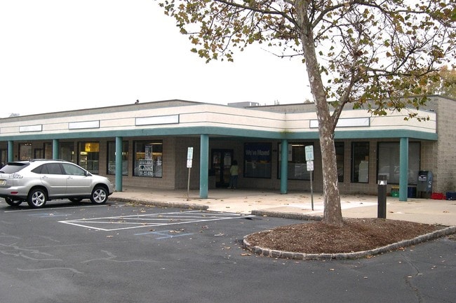
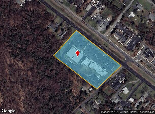
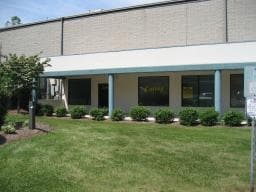
Property Record
431 Us Highway 22, Lebanon, NJ 08833

Current Lease Availabilities
NEARBY LISTINGS FOR SALE OR LEASE
Property Detail
431 Us Highway 22
22-00021-13-00015
Hunterdon
Regionalshoppingcenterormallwithanchorstore
New Jersey
X
15
34019C0144F
6.52 AC
2024
Hunterdon
2025
Northern New Jersey
010802
Newark, NJ-PA
DEMOGRAPHICS near 431 Us Highway 22
1 Mile
3 Mile
5 Mile
2024 Total Population
3,477
10,187
25,192
2029 Population
3,564
10,341
25,415
Pop Growth 2024-2029
+ 2.50%
+ 1.51%
+ 0.89%
Average Age
47
46
45
2024 Total Households
1,502
4,081
9,814
HH Growth 2024-2029
+ 2.26%
+ 1.49%
+ 0.88%
Median Household Inc
$101,923
$123,116
$136,858
Avg Household Size
2.30
2.40
2.50
2024 Avg HH Vehicles
2.00
2.00
2.00
Median Home Value
$460,869
$485,444
$523,559
Median Year Built
1990
1979
1980
Nearby Places
- Restaurants
- Banks
- Shops
- Fitness
- Groceries
PUBLIC TRANSPORTATION
COMMUTER RAIL
White House (Raritan Valley Line - NJ Transit Commuter Rail (NJ Transit))
DRIVE
WALK
Distance
White House (Raritan Valley Line - NJ Transit Commuter Rail (NJ Transit))
3 min
1.2 mi
Lebanon (Raritan Valley Line - NJ Transit Commuter Rail (NJ Transit))
DRIVE
WALK
Distance
Lebanon (Raritan Valley Line - NJ Transit Commuter Rail (NJ Transit))
9 min
4.4 mi
AIRPORT
Trenton Mercer
DRIVE
WALK
Distance
Trenton Mercer
58 min
31.0 mi
Freight Ports
New York Container Terminal
DRIVE
WALK
Distance
New York Container Terminal
53 min
41.1 mi
Nearby Properties
Address
Land Use
TOTAL SIZE
Lot Size
Zoning
Address
Land Use
TOTAL SIZE
Lot Size
Zoning
187,596 SF
54.59 AC
RO
Address
Land Use
TOTAL SIZE
Lot Size
Zoning
61.69 AC
RO
Address
Land Use
TOTAL SIZE
Lot Size
Zoning
8,000 SF
17.12 AC
RO
Address
Land Use
TOTAL SIZE
Lot Size
Zoning
14,182 SF
77.17 AC
ROMX
Address
Land Use
TOTAL SIZE
Lot Size
Zoning
118.92 AC
R10
Address
Land Use
TOTAL SIZE
Lot Size
Zoning
20 AC
AR
Address
Land Use
TOTAL SIZE
Lot Size
Zoning
46.18 AC
RR
Address
Land Use
TOTAL SIZE
Lot Size
Zoning
58,471 SF
8.69 AC
B
Address
Land Use
TOTAL SIZE
Lot Size
Zoning
20,048 SF
3 AC
AR
Address
Land Use
TOTAL SIZE
Lot Size
Zoning
127,961 SF
50 AC
B
Address
Land Use
TOTAL SIZE
Lot Size
Zoning
20,764 SF
21.01 AC
ROM1
Address
Land Use
TOTAL SIZE
Lot Size
Zoning
139 AC
AR
Address
Land Use
TOTAL SIZE
Lot Size
Zoning
23.40 AC
RR
Address
Land Use
TOTAL SIZE
Lot Size
Zoning
4,990 SF
254.59 AC
AH1
Address
Land Use
TOTAL SIZE
Lot Size
Zoning
9,348 SF
10.74 AC
B
Address
Land Use
TOTAL SIZE
Lot Size
Zoning
6.80 AC
VR
Address
Land Use
TOTAL SIZE
Lot Size
Zoning
11.28 AC
ROM1
Address
Land Use
TOTAL SIZE
Lot Size
Zoning
10.99 AC
ROM1
Address
Land Use
TOTAL SIZE
Lot Size
Zoning
Address
Land Use
TOTAL SIZE
Lot Size
Zoning
66.83 AC
ROM2
Address
Land Use
TOTAL SIZE
Lot Size
Zoning
37,951 SF
21.49 AC
AR
Address
Land Use
TOTAL SIZE
Lot Size
Zoning
62,140 SF
6 AC
B
Address
Land Use
TOTAL SIZE
Lot Size
Zoning
3,840 SF
5.72 AC
PO
Address
Land Use
TOTAL SIZE
Lot Size
Zoning
19,112 SF
51.81 AC
PM
Address
Land Use
TOTAL SIZE
Lot Size
Zoning
26 AC
RO
Address
Land Use
TOTAL SIZE
Lot Size
Zoning
53,392 SF
7.47 AC
PND1
Address
Land Use
TOTAL SIZE
Lot Size
Zoning
7.36 AC
ROM2
Address
Land Use
TOTAL SIZE
Lot Size
Zoning
6.56 AC
ROM3
Address
Land Use
TOTAL SIZE
Lot Size
Zoning
52,536 SF
7.14 AC
ROM2
The World's #1 Commercial Real Estate Marketplace
Connect with us
© 2025 CoStar Group
The information above has been obtained from sources believed reliable. While we do not doubt its accuracy we have not verified it and make no guarantee, warranty or representation about it. It is your responsibility to independently confirm its accuracy and completeness. Any projections, opinions, assumptions, or estimates used are for example only and do not represent the current or future performance of the property. The value of this transaction to you depends on tax and other factors which should be evaluated by your tax, financial, and legal advisors. You and your advisors should conduct a careful, independent investigation of the property to determine to your satisfaction the suitability of the property for your needs.