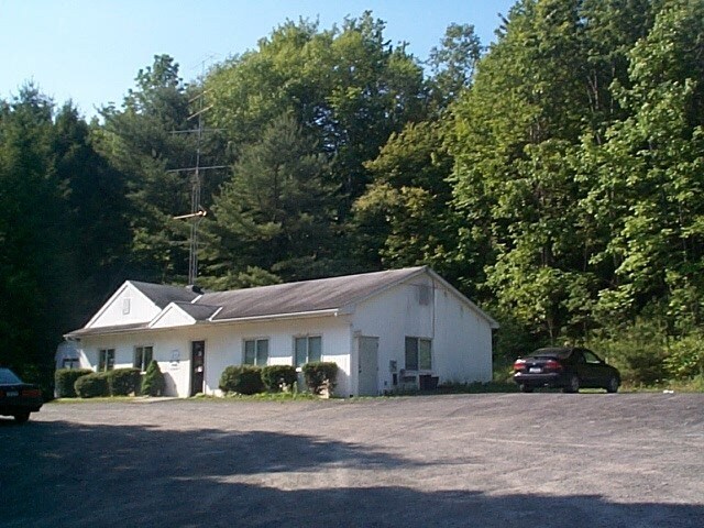
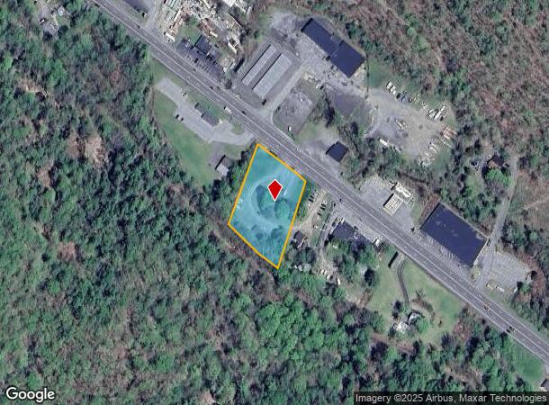
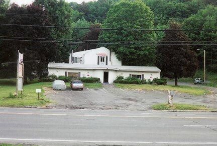
Property Record
431 Route 28, Kingston, NY 12401

NEARBY LISTINGS FOR SALE OR LEASE
Property Detail
431 Route 28
Apartment
Ulster
X
New York
36111C0460F
29.000
2025
1.33 AC
2024
Other Market Areas
952400
Kingston, NY
2,734 SF
5400-047.002-0003-029.000-0000
DEMOGRAPHICS near 431 Route 28
1 Mile
3 Mile
5 Mile
2024 Total Population
300
11,283
43,404
2029 Population
299
11,315
43,342
Pop Growth 2024-2029
(0.33%)
+ 0.28%
(0.14%)
Average Age
42
45
44
2024 Total Households
124
5,219
18,580
HH Growth 2024-2029
0.00%
+ 0.29%
(0.12%)
Median Household Inc
$86,918
$80,771
$74,285
Avg Household Size
2.40
2.10
2.20
2024 Avg HH Vehicles
2.00
2.00
2.00
Median Home Value
$518,750
$287,618
$269,939
Median Year Built
1982
1962
1957
Nearby Places
- Restaurants
- Banks
- Shops
- Fitness
- Groceries
PUBLIC TRANSPORTATION
AIRPORT
New York Stewart International
DRIVE
WALK
Distance
New York Stewart International
53 min
39.9 mi
Freight Ports
Albany, NY Port
DRIVE
WALK
Distance
Albany, NY Port
67 min
53.3 mi
Nearby Properties
Address
Land Use
TOTAL SIZE
Lot Size
Zoning
Address
Land Use
TOTAL SIZE
Lot Size
Zoning
135,158 SF
31.80 AC
R-1
Address
Land Use
TOTAL SIZE
Lot Size
Zoning
24,321 SF
46.40 AC
T2C
Address
Land Use
TOTAL SIZE
Lot Size
Zoning
76,788 SF
0.77 AC
T5N
Address
Land Use
TOTAL SIZE
Lot Size
Zoning
152,723 SF
9.60 AC
SD
Address
Land Use
TOTAL SIZE
Lot Size
Zoning
97,636 SF
2.60 AC
T5MS
Address
Land Use
TOTAL SIZE
Lot Size
Zoning
23.30 AC
37
Address
Land Use
TOTAL SIZE
Lot Size
Zoning
8,674 SF
10.90 AC
SD
Address
Land Use
TOTAL SIZE
Lot Size
Zoning
10,124 SF
7.50 AC
SD
Address
Land Use
TOTAL SIZE
Lot Size
Zoning
5,488 SF
15 AC
33
Address
Land Use
TOTAL SIZE
Lot Size
Zoning
47,038 SF
4.96 AC
T5N
Address
Land Use
TOTAL SIZE
Lot Size
Zoning
40,610 SF
1.30 AC
T5MS
Address
Land Use
TOTAL SIZE
Lot Size
Zoning
77.80 AC
37
Address
Land Use
TOTAL SIZE
Lot Size
Zoning
29,964 SF
5.90 AC
SD
Address
Land Use
TOTAL SIZE
Lot Size
Zoning
6,564 SF
2.70 AC
30
Address
Land Use
TOTAL SIZE
Lot Size
Zoning
92,049 SF
1.90 AC
35
Address
Land Use
TOTAL SIZE
Lot Size
Zoning
12,771 SF
6.50 AC
SD
Address
Land Use
TOTAL SIZE
Lot Size
Zoning
54,433 SF
18 AC
T3N
Address
Land Use
TOTAL SIZE
Lot Size
Zoning
14,759 SF
1.70 AC
T5N
Address
Land Use
TOTAL SIZE
Lot Size
Zoning
2,544 SF
6.70 AC
37
Address
Land Use
TOTAL SIZE
Lot Size
Zoning
33,744 SF
1.80 AC
T4N-O
Address
Land Use
TOTAL SIZE
Lot Size
Zoning
32,000 SF
7.90 AC
35
Address
Land Use
TOTAL SIZE
Lot Size
Zoning
19,176 SF
1.90 AC
T4N-O
Address
Land Use
TOTAL SIZE
Lot Size
Zoning
10,894 SF
3.30 AC
SD
Address
Land Use
TOTAL SIZE
Lot Size
Zoning
2,040 SF
11.23 AC
37
Address
Land Use
TOTAL SIZE
Lot Size
Zoning
1,997 SF
9.30 AC
SD
Address
Land Use
TOTAL SIZE
Lot Size
Zoning
9,000 SF
5.80 AC
SD
Address
Land Use
TOTAL SIZE
Lot Size
Zoning
40,767 SF
4.65 AC
35
Address
Land Use
TOTAL SIZE
Lot Size
Zoning
18,260 SF
2 AC
T4N-O
Address
Land Use
TOTAL SIZE
Lot Size
Zoning
14,475 SF
0.62 AC
T5N
Address
Land Use
TOTAL SIZE
Lot Size
Zoning
98,464 SF
14.50 AC
37
The World's #1 Commercial Real Estate Marketplace
Connect with us
© 2025 CoStar Group
The information above has been obtained from sources believed reliable. While we do not doubt its accuracy we have not verified it and make no guarantee, warranty or representation about it. It is your responsibility to independently confirm its accuracy and completeness. Any projections, opinions, assumptions, or estimates used are for example only and do not represent the current or future performance of the property. The value of this transaction to you depends on tax and other factors which should be evaluated by your tax, financial, and legal advisors. You and your advisors should conduct a careful, independent investigation of the property to determine to your satisfaction the suitability of the property for your needs.