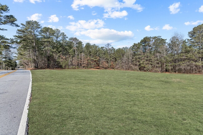
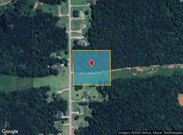
Property Record
431 Veal Rd, Covington, GA 30016

NEARBY LISTINGS FOR SALE OR LEASE
Property Detail
431 Veal Rd
Atlanta-Sandy Springs-Roswell, GA
Livingston Lane & Veals Landing
0007C00000017000
LTA-15 VEALS LANDING LD10
Residentialacreage
Newton
X
Georgia
13217C0115D
a-15
2025
3.50 AC
2025
Newton County
100905
Atlanta
DEMOGRAPHICS near 431 Veal Rd
1 Mile
3 Mile
5 Mile
2024 Total Population
1,956
21,386
65,047
2029 Population
2,131
23,112
69,874
Pop Growth 2024-2029
+ 8.95%
+ 8.07%
+ 7.42%
Average Age
39
39
39
2024 Total Households
681
7,401
22,208
HH Growth 2024-2029
+ 9.25%
+ 8.26%
+ 7.56%
Median Household Inc
$72,151
$79,598
$77,299
Avg Household Size
2.90
2.90
2.90
2024 Avg HH Vehicles
2.00
2.00
2.00
Median Home Value
$192,479
$180,982
$201,752
Median Year Built
1999
1995
1996
Nearby Places
Map Layers
Map Styles
 Street
 Aerial
- Restaurants
- Banks
- Shops
- Fitness
- Groceries
PUBLIC TRANSPORTATION
AIRPORT
Hartsfield - Jackson Atlanta International
DRIVE
WALK
Distance
Hartsfield - Jackson Atlanta International
53 min
33.2 mi
Freight Ports
Georgia Ports - Savannah
DRIVE
WALK
Distance
Georgia Ports - Savannah
269 min
233.5 mi
Nearby Properties
Address
Land Use
TOTAL SIZE
Lot Size
Zoning
Address
Land Use
TOTAL SIZE
Lot Size
Zoning
1,158,095 SF
161.26 AC
Address
Land Use
TOTAL SIZE
Lot Size
Zoning
1,158,095 SF
0.01 AC
Address
Land Use
TOTAL SIZE
Lot Size
Zoning
65,360 SF
75.51 AC
E6
Address
Land Use
TOTAL SIZE
Lot Size
Zoning
81,730 SF
17.98 AC
C1
Address
Land Use
TOTAL SIZE
Lot Size
Zoning
65,360 SF
30.63 AC
E6
Address
Land Use
TOTAL SIZE
Lot Size
Zoning
50,096 SF
4.19 AC
C1
Address
Land Use
TOTAL SIZE
Lot Size
Zoning
63,328 SF
10.67 AC
C2
Address
Land Use
TOTAL SIZE
Lot Size
Zoning
58,892 SF
17.52 AC
E6
Address
Land Use
TOTAL SIZE
Lot Size
Zoning
18,751 SF
4.14 AC
C2/OI
Address
Land Use
TOTAL SIZE
Lot Size
Zoning
6,000 SF
2.61 AC
C1
Address
Land Use
TOTAL SIZE
Lot Size
Zoning
19,363 SF
4 AC
AR
Address
Land Use
TOTAL SIZE
Lot Size
Zoning
17,558 SF
5.08 AC
AR/C1
Address
Land Use
TOTAL SIZE
Lot Size
Zoning
3,500 SF
0.85 AC
C1
Address
Land Use
TOTAL SIZE
Lot Size
Zoning
13,182 SF
1.89 AC
CN
Address
Land Use
TOTAL SIZE
Lot Size
Zoning
12,600 SF
1.33 AC
C2
Address
Land Use
TOTAL SIZE
Lot Size
Zoning
12,934 SF
2.37 AC
E3
Address
Land Use
TOTAL SIZE
Lot Size
Zoning
2,065 SF
15 AC
E2
Address
Land Use
TOTAL SIZE
Lot Size
Zoning
16,620 SF
10.86 AC
AR
Address
Land Use
TOTAL SIZE
Lot Size
Zoning
7,200 SF
1.07 AC
C2/C
Address
Land Use
TOTAL SIZE
Lot Size
Zoning
359.47 AC
A
Address
Land Use
TOTAL SIZE
Lot Size
Zoning
3,780 SF
78.28 AC
E2
Address
Land Use
TOTAL SIZE
Lot Size
Zoning
8,400 SF
6.03 AC
AR
Address
Land Use
TOTAL SIZE
Lot Size
Zoning
1,754 SF
1.14 AC
C2
Address
Land Use
TOTAL SIZE
Lot Size
Zoning
218.14 AC
Address
Land Use
TOTAL SIZE
Lot Size
Zoning
4,745 SF
0.63 AC
C1
Address
Land Use
TOTAL SIZE
Lot Size
Zoning
4,800 SF
1.41 AC
C1
Address
Land Use
TOTAL SIZE
Lot Size
Zoning
7,980 SF
5 AC
AR
Address
Land Use
TOTAL SIZE
Lot Size
Zoning
6,000 SF
15.13 AC
AR
Address
Land Use
TOTAL SIZE
Lot Size
Zoning
8,400 SF
0.82 AC
C1
Address
Land Use
TOTAL SIZE
Lot Size
Zoning
4,200 SF
2.15 AC
C1
The World's #1 Commercial Real Estate Marketplace
Connect with us
© 2026 CoStar Group
The information above has been obtained from sources believed reliable. While we do not doubt its accuracy we have not verified it and make no guarantee, warranty or representation about it. It is your responsibility to independently confirm its accuracy and completeness. Any projections, opinions, assumptions, or estimates used are for example only and do not represent the current or future performance of the property. The value of this transaction to you depends on tax and other factors which should be evaluated by your tax, financial, and legal advisors. You and your advisors should conduct a careful, independent investigation of the property to determine to your satisfaction the suitability of the property for your needs.