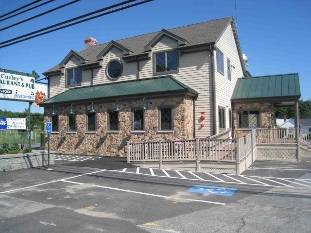
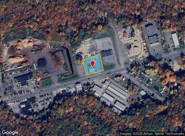
Property Record
431 Winthrop St, Taunton, MA 02780
NEARBY LISTINGS FOR SALE OR LEASE
Property Detail
431 Winthrop St
TAUN-000089-000002
Bristol
Restaurantbuilding
Massachusetts
X
2
25005C0144F
0.83 AC
2025
Attleboro/New Bedford
2025
Boston
613400
Providence-Warwick, RI-MA
4,544 SF
DEMOGRAPHICS near 431 Winthrop St
1 Mile
3 Mile
5 Mile
2024 Total Population
1,449
31,458
66,379
2029 Population
1,439
31,126
65,753
Pop Growth 2024-2029
(0.69%)
(1.06%)
(0.94%)
Average Age
42
41
41
2024 Total Households
535
12,588
25,983
HH Growth 2024-2029
(0.75%)
(1.09%)
(1.00%)
Median Household Inc
$117,856
$69,226
$72,595
Avg Household Size
2.70
2.40
2.50
2024 Avg HH Vehicles
2.00
2.00
2.00
Median Home Value
$428,333
$365,401
$376,207
Median Year Built
1990
1965
1968
Nearby Places
Map Layers
Map Styles
 Street
 Aerial
- Restaurants
- Banks
- Shops
- Fitness
- Groceries
PUBLIC TRANSPORTATION
AIRPORT
Rhode Island Tf Green International
DRIVE
WALK
Distance
Rhode Island Tf Green International
38 min
22.3 mi
Freight Ports
Port of New Bedford Harbor
DRIVE
WALK
Distance
Port of New Bedford Harbor
37 min
25.8 mi
Nearby Properties
Address
Land Use
TOTAL SIZE
Lot Size
Zoning
Address
Land Use
TOTAL SIZE
Lot Size
Zoning
68,024 SF
66.24 AC
RURRES
Address
Land Use
TOTAL SIZE
Lot Size
Zoning
279,756 SF
11.62 AC
OFFDIS
Address
Land Use
TOTAL SIZE
Lot Size
Zoning
130,851 SF
24.43 AC
URBRES
Address
Land Use
TOTAL SIZE
Lot Size
Zoning
147,285 SF
0.79 AC
CENBIZ
Address
Land Use
TOTAL SIZE
Lot Size
Zoning
157.20 AC
OPSPAC
Address
Land Use
TOTAL SIZE
Lot Size
Zoning
37.62 AC
URBRES
Address
Land Use
TOTAL SIZE
Lot Size
Zoning
39,910 SF
1.05 AC
CENBIZ
Address
Land Use
TOTAL SIZE
Lot Size
Zoning
5.20 AC
URBRES
Address
Land Use
TOTAL SIZE
Lot Size
Zoning
52,042 SF
59.53 AC
OPSPAC
Address
Land Use
TOTAL SIZE
Lot Size
Zoning
36,336 SF
6.35 AC
RURRES
Address
Land Use
TOTAL SIZE
Lot Size
Zoning
44,581 SF
14.60 AC
RURRES
Address
Land Use
TOTAL SIZE
Lot Size
Zoning
61,128 SF
0.98 AC
Address
Land Use
TOTAL SIZE
Lot Size
Zoning
3 AC
URBRES
Address
Land Use
TOTAL SIZE
Lot Size
Zoning
24 AC
HIWABZ
Address
Land Use
TOTAL SIZE
Lot Size
Zoning
164,658 SF
15.18 AC
BIZDIS
Address
Land Use
TOTAL SIZE
Lot Size
Zoning
29,400 SF
12.91 AC
I
Address
Land Use
TOTAL SIZE
Lot Size
Zoning
4.53 AC
URBRES
Address
Land Use
TOTAL SIZE
Lot Size
Zoning
38,422 SF
0.82 AC
OFFDIS
Address
Land Use
TOTAL SIZE
Lot Size
Zoning
244,320 SF
13.66 AC
INDUST
Address
Land Use
TOTAL SIZE
Lot Size
Zoning
91,289 SF
3.82 AC
URBRES
Address
Land Use
TOTAL SIZE
Lot Size
Zoning
5,616 SF
10 AC
URBRES
Address
Land Use
TOTAL SIZE
Lot Size
Zoning
5.26 AC
URBRES
Address
Land Use
TOTAL SIZE
Lot Size
Zoning
120 AC
OPSPAC
Address
Land Use
TOTAL SIZE
Lot Size
Zoning
58,078 SF
6.10 AC
HIWABZ
Address
Land Use
TOTAL SIZE
Lot Size
Zoning
72,833 SF
6.98 AC
HIWABZ
Address
Land Use
TOTAL SIZE
Lot Size
Zoning
40,552 SF
10.07 AC
Address
Land Use
TOTAL SIZE
Lot Size
Zoning
70,020 SF
1.13 AC
CENBIZ
Address
Land Use
TOTAL SIZE
Lot Size
Zoning
50 AC
URBRES
Address
Land Use
TOTAL SIZE
Lot Size
Zoning
132,574 SF
7.70 AC
RURRES
Address
Land Use
TOTAL SIZE
Lot Size
Zoning
142,832 SF
6.57 AC
BIZDIS
The World's #1 Commercial Real Estate Marketplace
Connect with us
© 2025 CoStar Group
The information above has been obtained from sources believed reliable. While we do not doubt its accuracy we have not verified it and make no guarantee, warranty or representation about it. It is your responsibility to independently confirm its accuracy and completeness. Any projections, opinions, assumptions, or estimates used are for example only and do not represent the current or future performance of the property. The value of this transaction to you depends on tax and other factors which should be evaluated by your tax, financial, and legal advisors. You and your advisors should conduct a careful, independent investigation of the property to determine to your satisfaction the suitability of the property for your needs.