Property Record
4310 Barkoskie Rd, Jacksonville, FL 32258


This Property Is For Sale
NEARBY LISTINGS FOR SALE OR LEASE
Property Detail
4310 Barkoskie Rd
Jacksonville, FL
Section Land
158959-0000
42-4S-27E .86 F HARTLEY GRANT PT RECD O/R 19449-1053(EX PT IN CITY ST)
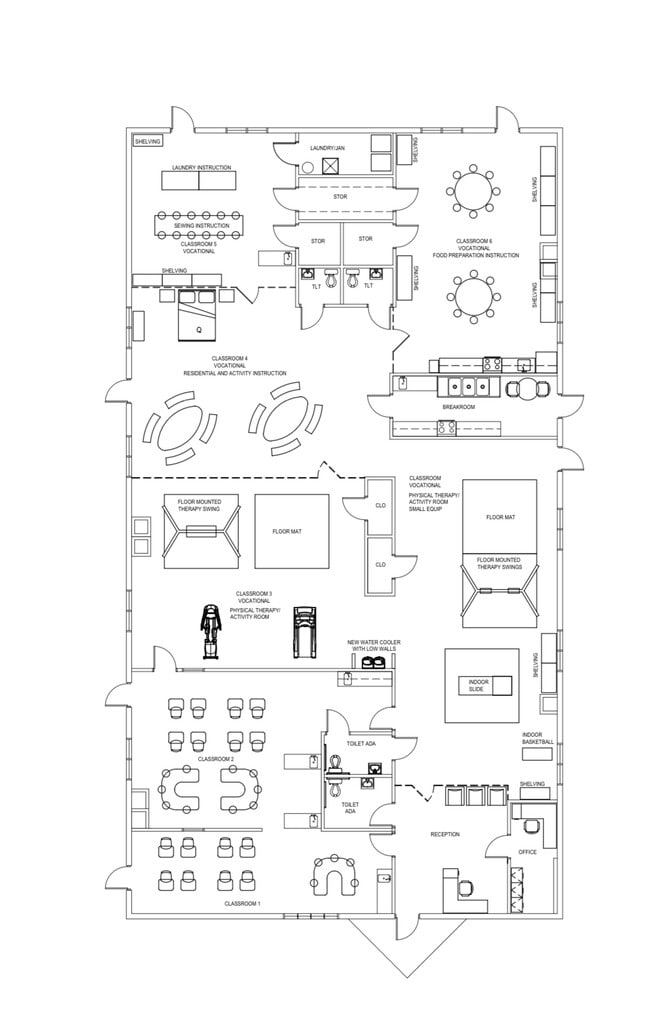
Daycare
Duval
X
Florida
12031C0561H
332
2025
0.84 AC
2026
Mandarin
016810
Jacksonville (Florida)
6,290 SF
DEMOGRAPHICS near 4310 Barkoskie Rd
1 Mile
3 Mile
5 Mile
2024 Total Population
9,033
67,163
146,718
2029 Population
9,279
70,730
160,885
Pop Growth 2024-2029
+ 2.72%
+ 5.31%
+ 9.66%
Average Age
41
42
40
2024 Total Households
3,646
26,177
58,646
HH Growth 2024-2029
+ 2.69%
+ 5.01%
+ 8.68%
Median Household Inc
$75,227
$83,297
$83,160
Avg Household Size
2.40
2.50
2.40
2024 Avg HH Vehicles
2.00
2.00
2.00
Median Home Value
$285,960
$287,887
$313,178
Median Year Built
1988
1987
1990
Nearby Places
Map Layers
Map Styles
 Street
 Aerial
- Restaurants
- Banks
- Shops
- Fitness
- Groceries
PUBLIC TRANSPORTATION
AIRPORT
Jacksonville International
DRIVE
WALK
Distance
Jacksonville International
44 min
33.9 mi
Freight Ports
Jacksonville Port
DRIVE
WALK
Distance
Jacksonville Port
30 min
19.8 mi
Nearby Properties
Address
Land Use
TOTAL SIZE
Lot Size
Zoning
Address
Land Use
TOTAL SIZE
Lot Size
Zoning
345,678 SF
30.40 AC
PUD
Address
Land Use
TOTAL SIZE
Lot Size
Zoning
438,224 SF
35.14 AC
RMD-D
Address
Land Use
TOTAL SIZE
Lot Size
Zoning
287,406 SF
32.10 AC
CCG-1
Address
Land Use
TOTAL SIZE
Lot Size
Zoning
193,858 SF
8.67 AC
PUD
Address
Land Use
TOTAL SIZE
Lot Size
Zoning
266,087 SF
35.07 AC
RMD-D
Address
Land Use
TOTAL SIZE
Lot Size
Zoning
304,017 SF
20.58 AC
RMD-D
Address
Land Use
TOTAL SIZE
Lot Size
Zoning
291,833 SF
16.91 AC
CRO
Address
Land Use
TOTAL SIZE
Lot Size
Zoning
236,068 SF
18.87 AC
PUD
Address
Land Use
TOTAL SIZE
Lot Size
Zoning
404,315 SF
19.27 AC
RMD-D
Address
Land Use
TOTAL SIZE
Lot Size
Zoning
304,277 SF
25.03 AC
CCG-2
Address
Land Use
TOTAL SIZE
Lot Size
Zoning
166,126 SF
17.26 AC
CCG-1
Address
Land Use
TOTAL SIZE
Lot Size
Zoning
273,060 SF
23.70 AC
CCG-1
Address
Land Use
TOTAL SIZE
Lot Size
Zoning
240,240 SF
13.91 AC
PUD
Address
Land Use
TOTAL SIZE
Lot Size
Zoning
148,931 SF
16.93 AC
RMD-D
Address
Land Use
TOTAL SIZE
Lot Size
Zoning
248,748 SF
17.60 AC
RMD-D
Address
Land Use
TOTAL SIZE
Lot Size
Zoning
96,065 SF
4.11 AC
PUD
Address
Land Use
TOTAL SIZE
Lot Size
Zoning
177,088 SF
15.02 AC
RMD-D
Address
Land Use
TOTAL SIZE
Lot Size
Zoning
263,796 SF
36.89 AC
PUD
Address
Land Use
TOTAL SIZE
Lot Size
Zoning
265,371 SF
18.26 AC
IH
Address
Land Use
TOTAL SIZE
Lot Size
Zoning
330,139 SF
73.17 AC
PBF-1
Address
Land Use
TOTAL SIZE
Lot Size
Zoning
246,534 SF
18.99 AC
RMD-D
Address
Land Use
TOTAL SIZE
Lot Size
Zoning
264,352 SF
20.49 AC
PUD
Address
Land Use
TOTAL SIZE
Lot Size
Zoning
388,745 SF
49.78 AC
PBF-1
Address
Land Use
TOTAL SIZE
Lot Size
Zoning
321,392 SF
42.84 AC
PUD
Address
Land Use
TOTAL SIZE
Lot Size
Zoning
150,805 SF
26.63 AC
CRO
Address
Land Use
TOTAL SIZE
Lot Size
Zoning
114,215 SF
14.08 AC
PUD
Address
Land Use
TOTAL SIZE
Lot Size
Zoning
224,180 SF
18.48 AC
PUD
Address
Land Use
TOTAL SIZE
Lot Size
Zoning
217,560 SF
17.08 AC
CCG-1
Address
Land Use
TOTAL SIZE
Lot Size
Zoning
80,974 SF
4.94 AC
CCG-1
Address
Land Use
TOTAL SIZE
Lot Size
Zoning
80,366 SF
10.80 AC
RMD-D
The World's #1 Commercial Real Estate Marketplace
Connect with us
© 2026 CoStar Group
The information above has been obtained from sources believed reliable. While we do not doubt its accuracy we have not verified it and make no guarantee, warranty or representation about it. It is your responsibility to independently confirm its accuracy and completeness. Any projections, opinions, assumptions, or estimates used are for example only and do not represent the current or future performance of the property. The value of this transaction to you depends on tax and other factors which should be evaluated by your tax, financial, and legal advisors. You and your advisors should conduct a careful, independent investigation of the property to determine to your satisfaction the suitability of the property for your needs.