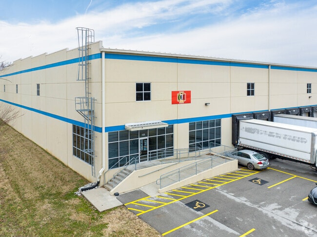
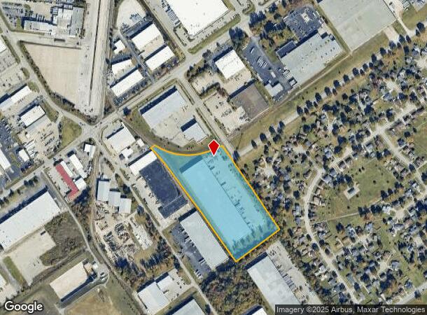
Property Record
4310 Chefs Way, Louisville, KY 40218

NEARBY LISTINGS FOR SALE OR LEASE
Property Detail
4310 Chefs Way
Louisville-Jefferson County, KY-IN
Farm Land Co
061601780000
TRACT 3 PER PLAT ATT DB 9085 X 819
Warehouse
Jefferson
X
Kentucky
21111C0077F
11.42 AC
2025
South Central
2025
Louisville
011301
DEMOGRAPHICS near 4310 Chefs Way
1 Mile
3 Mile
5 Mile
2024 Total Population
7,406
87,076
228,464
2029 Population
7,321
85,758
224,858
Pop Growth 2024-2029
(1.15%)
(1.51%)
(1.58%)
Average Age
38
39
40
2024 Total Households
2,807
36,491
99,105
HH Growth 2024-2029
(1.28%)
(1.58%)
(1.66%)
Median Household Inc
$50,089
$53,439
$61,423
Avg Household Size
2.50
2.30
2.20
2024 Avg HH Vehicles
2.00
2.00
2.00
Median Home Value
$109,609
$180,412
$214,997
Median Year Built
1966
1964
1963
Nearby Places
Map Layers
Map Styles
 Street
 Aerial
- Restaurants
- Banks
- Shops
- Fitness
- Groceries
PUBLIC TRANSPORTATION
AIRPORT
Louisville Muhammad Ali International
DRIVE
WALK
Distance
Louisville Muhammad Ali International
17 min
8.1 mi
Freight Ports
Port of Toledo
DRIVE
WALK
Distance
Port of Toledo
358 min
307.1 mi
SALE & LEASE HISTORY
LISTING DATE
SALE/LEASE

May 23, 2022
For Lease
May 19, 2017
For Lease
Aug 23, 2017
For Lease
Nearby Properties
Address
Land Use
TOTAL SIZE
Lot Size
Zoning
Address
Land Use
TOTAL SIZE
Lot Size
Zoning
85,882 SF
80.13 AC
R1-RESIDEN
Address
Land Use
TOTAL SIZE
Lot Size
Zoning
127,824 SF
53.76 AC
M2-INDUSTR
Address
Land Use
TOTAL SIZE
Lot Size
Zoning
19.16 AC
Address
Land Use
TOTAL SIZE
Lot Size
Zoning
32.44 AC
Address
Land Use
TOTAL SIZE
Lot Size
Zoning
14,166 SF
16.32 AC
C1-COMMERC
Address
Land Use
TOTAL SIZE
Lot Size
Zoning
407,840 SF
25.51 AC
C2-COMMERC
Address
Land Use
TOTAL SIZE
Lot Size
Zoning
4,745 SF
17.95 AC
Address
Land Use
TOTAL SIZE
Lot Size
Zoning
12,852 SF
10.85 AC
R7-RESIDEN
Address
Land Use
TOTAL SIZE
Lot Size
Zoning
5,200 SF
7.55 AC
R7-RESIDEN
Address
Land Use
TOTAL SIZE
Lot Size
Zoning
142,874 SF
21.93 AC
R5-RESIDEN
Address
Land Use
TOTAL SIZE
Lot Size
Zoning
1,450 SF
87.64 AC
M2-INDUSTR
Address
Land Use
TOTAL SIZE
Lot Size
Zoning
217,082 SF
26.08 AC
C1-COMMERC
Address
Land Use
TOTAL SIZE
Lot Size
Zoning
401,443 SF
28.92 AC
M2-INDUSTR
Address
Land Use
TOTAL SIZE
Lot Size
Zoning
2,575 SF
4.39 AC
CM-COMMERC
Address
Land Use
TOTAL SIZE
Lot Size
Zoning
27.92 AC
EZ1-ENTERP
Address
Land Use
TOTAL SIZE
Lot Size
Zoning
16,836 SF
13.72 AC
R6-RESIDEN
Address
Land Use
TOTAL SIZE
Lot Size
Zoning
14,880 SF
12.98 AC
R6-RESIDEN
Address
Land Use
TOTAL SIZE
Lot Size
Zoning
25,326 SF
11.36 AC
R7-RESIDEN
Address
Land Use
TOTAL SIZE
Lot Size
Zoning
15.24 AC
Address
Land Use
TOTAL SIZE
Lot Size
Zoning
370,297 SF
28.31 AC
M2-INDUSTR
Address
Land Use
TOTAL SIZE
Lot Size
Zoning
17.17 AC
EZ1-ENTERP
Address
Land Use
TOTAL SIZE
Lot Size
Zoning
6,570 SF
7.06 AC
R7-RESIDEN
Address
Land Use
TOTAL SIZE
Lot Size
Zoning
24,290 SF
14.88 AC
C2-COMMERC
Address
Land Use
TOTAL SIZE
Lot Size
Zoning
18.67 AC
Address
Land Use
TOTAL SIZE
Lot Size
Zoning
6,092 SF
7.65 AC
R5-RESIDEN
Address
Land Use
TOTAL SIZE
Lot Size
Zoning
4,000 SF
15.46 AC
C2-COMMERC
Address
Land Use
TOTAL SIZE
Lot Size
Zoning
14.13 AC
R4-RESIDEN
Address
Land Use
TOTAL SIZE
Lot Size
Zoning
15.08 AC
C1-COMMERC
Address
Land Use
TOTAL SIZE
Lot Size
Zoning
15,168 SF
9.12 AC
C2-COMMERC
Address
Land Use
TOTAL SIZE
Lot Size
Zoning
14,492 SF
9.07 AC
R7-RESIDEN
The World's #1 Commercial Real Estate Marketplace
Connect with us
© 2025 CoStar Group
The information above has been obtained from sources believed reliable. While we do not doubt its accuracy we have not verified it and make no guarantee, warranty or representation about it. It is your responsibility to independently confirm its accuracy and completeness. Any projections, opinions, assumptions, or estimates used are for example only and do not represent the current or future performance of the property. The value of this transaction to you depends on tax and other factors which should be evaluated by your tax, financial, and legal advisors. You and your advisors should conduct a careful, independent investigation of the property to determine to your satisfaction the suitability of the property for your needs.