Property Record
4310 E 60Th Ave, Commerce City, CO 80022


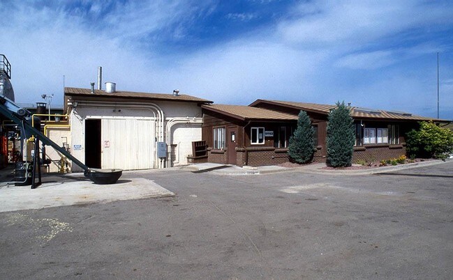

Property Detail
4310 E 60Th Ave
Denver-Aurora-Centennial, CO
SUB:RO JO SUBD BLK:1 DESC: PT OF LOT 2 BLK 1 DESC AS FOLS BEG AT NE COR NW4 SW4 SEC 7/3/67 TH S 25 FT TO BDRY RO JO SUBD TH S 5 FT TH ALG SLY ROW LN 60TH AVE BEING 30 FT SLY FROM AND // TO N LN NW4 SW4 E 572/86 FT TH ALG SD BDRY S 350 FT TH CONT ALG
1823-07-3-01-007
Adams
Industrialgeneral
Colorado
C and X Area of minimal flood hazard, usually depicted on FIRMs as above the 500-year flood level.
2
2024
5.08 AC
2025
Northeast Denver
008901
Denver
11,810 SF
NEARBY LISTINGS FOR SALE OR LEASE
-
-
View all Commerce City listings for sale on LoopNet.com
DEMOGRAPHICS near 4310 E 60Th Ave
1 mile
3 mile
5 mile
2024 Total Population
2,794
58,689
305,910
2029 Population
2,915
60,748
315,485
Pop Growth 2024-2029
+ 4.33%
+ 3.51%
+ 3.13%
Average Age
36
36
37
2024 Total Households
882
19,226
126,975
HH Growth 2024-2029
+ 4.54%
+ 3.67%
+ 3.24%
Median Household Inc
$73,178
$72,942
$98,450
Avg Household Size
3.00
2.90
2.30
2024 Avg HH Vehicles
2.00
2.00
2.00
Median Home Value
$347,679
$422,146
$582,516
Median Year Built
1965
1965
1976
Nearby Places
Map Layers
Map Styles
 Street
 Aerial
Transit
 Traffic
 Biking
Places
Listings with unknown addresses are not visible on the map
- Restaurants
- Banks
- Shops
- Fitness
- Groceries
PUBLIC TRANSPORTATION
COMMUTER RAIL
Commerce City - 72Nd Station Track 1 (Union Station to Eastlake & 124th Station - Regional Transportation District)
Drive
Walk
Distance
Commerce City - 72Nd Station Track 1 (Union Station to Eastlake & 124th Station - Regional Transportation District)
7 min
2.9 mi
40Th & Colorado Station Track 1 (Union Station to Denver Airport Station - Regional Transportation District)
Drive
Walk
Distance
40Th & Colorado Station Track 1 (Union Station to Denver Airport Station - Regional Transportation District)
6 min
3.1 mi
AIRPORT
Denver International
Drive
Walk
Distance
Denver International
28 min
20.9 mi
Freight Ports
Tulsa Port Of Catoosa
Drive
Walk
Distance
Tulsa Port Of Catoosa
726 min
706.4 mi
Nearby Properties
Address
Land Use
TOTAL SIZE
Lot Size
Zoning
Address
Land Use
TOTAL SIZE
Lot Size
Zoning
396,741 SF
8.12 AC
A1
Address
Land Use
TOTAL SIZE
Lot Size
Zoning
1.64 AC
CMP
Address
Land Use
TOTAL SIZE
Lot Size
Zoning
256,155 SF
3.84 AC
Address
Land Use
TOTAL SIZE
Lot Size
Zoning
3,188 SF
81.17 AC
I-B
Address
Land Use
TOTAL SIZE
Lot Size
Zoning
269,025 SF
18.86 AC
M-RX-5
Address
Land Use
TOTAL SIZE
Lot Size
Zoning
140,328 SF
6.54 AC
PUD
Address
Land Use
TOTAL SIZE
Lot Size
Zoning
17,063 SF
2.01 AC
Address
Land Use
TOTAL SIZE
Lot Size
Zoning
649,540 SF
33.65 AC
Address
Land Use
TOTAL SIZE
Lot Size
Zoning
446,845 SF
10.43 AC
CMP-NWC-G
Address
Land Use
TOTAL SIZE
Lot Size
Zoning
134,729 SF
5.57 AC
Address
Land Use
TOTAL SIZE
Lot Size
Zoning
551,915 SF
25.76 AC
Address
Land Use
TOTAL SIZE
Lot Size
Zoning
599,680 SF
43.94 AC
Address
Land Use
TOTAL SIZE
Lot Size
Zoning
595,017 SF
11.62 AC
I-B
Address
Land Use
TOTAL SIZE
Lot Size
Zoning
116,502 SF
4.08 AC
Address
Land Use
TOTAL SIZE
Lot Size
Zoning
344,689 SF
11.77 AC
I-B
Address
Land Use
TOTAL SIZE
Lot Size
Zoning
296,000 SF
52.44 AC
A3
Address
Land Use
TOTAL SIZE
Lot Size
Zoning
94,213 SF
3.84 AC
A1
Address
Land Use
TOTAL SIZE
Lot Size
Zoning
419,745 SF
24.75 AC
Address
Land Use
TOTAL SIZE
Lot Size
Zoning
146,217 SF
5.28 AC
I-MX-8
Address
Land Use
TOTAL SIZE
Lot Size
Zoning
340,000 SF
2.65 AC
C-MX-8
Address
Land Use
TOTAL SIZE
Lot Size
Zoning
439,200 SF
25.09 AC
Address
Land Use
TOTAL SIZE
Lot Size
Zoning
138,799 SF
16.28 AC
I-A
Address
Land Use
TOTAL SIZE
Lot Size
Zoning
90,760 SF
6.48 AC
Address
Land Use
TOTAL SIZE
Lot Size
Zoning
268,268 SF
29.99 AC
I-B
Address
Land Use
TOTAL SIZE
Lot Size
Zoning
177,366 SF
3.85 AC
C-MX-8
Address
Land Use
TOTAL SIZE
Lot Size
Zoning
341,009 SF
2.36 AC
I-MX-8
Address
Land Use
TOTAL SIZE
Lot Size
Zoning
6.69 AC
B-3
Address
Land Use
TOTAL SIZE
Lot Size
Zoning
293,784 SF
2.27 AC
I-MX-12
Address
Land Use
TOTAL SIZE
Lot Size
Zoning
179,691 SF
4.05 AC
I-MX-8
Address
Land Use
TOTAL SIZE
Lot Size
Zoning
194,976 SF
4.48 AC
I-MX-12
The World's #1 Commercial Real Estate Marketplace
Connect with us
© 2026 CoStar Group
The information above has been obtained from sources believed reliable. While we do not doubt its accuracy we have not verified it and make no guarantee, warranty or representation about it. It is your responsibility to independently confirm its accuracy and completeness. Any projections, opinions, assumptions, or estimates used are for example only and do not represent the current or future performance of the property. The value of this transaction to you depends on tax and other factors which should be evaluated by your tax, financial, and legal advisors. You and your advisors should conduct a careful, independent investigation of the property to determine to your satisfaction the suitability of the property for your needs.