Property Record
4310 Lockwood Dr, Houston, TX 77026
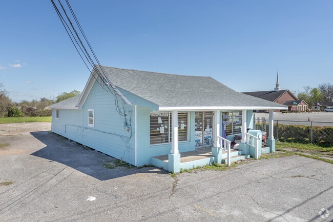


This Property Is For Sale
NEARBY LISTINGS FOR SALE OR LEASE
Property Detail
4310 Lockwood Dr
Houston-The Woodlands-Sugar Land, TX
Kashmere Gardens
0651240410644
LT 644 BLK 41 KASHMERE GARDENS
Storebuilding
Harris
AE
Texas
48201C0690N
644
2024
0.34 AC
2025
I-10 East
211700
Houston
1,740 SF
DEMOGRAPHICS near 4310 Lockwood Dr
1 Mile
3 Mile
5 Mile
2024 Total Population
11,730
99,176
306,441
2029 Population
12,251
102,967
317,257
Pop Growth 2024-2029
+ 4.44%
+ 3.82%
+ 3.53%
Average Age
39
37
37
2024 Total Households
4,370
34,980
114,558
HH Growth 2024-2029
+ 4.37%
+ 3.91%
+ 3.84%
Median Household Inc
$27,323
$33,881
$46,913
Avg Household Size
2.60
2.80
2.50
2024 Avg HH Vehicles
1.00
2.00
2.00
Median Home Value
$95,965
$128,982
$189,130
Median Year Built
1962
1960
1965
Nearby Places
Map Layers
Map Styles
 Street
 Aerial
- Restaurants
- Banks
- Shops
- Fitness
- Groceries
PUBLIC TRANSPORTATION
COMMUTER RAIL
Houston (Sunset Limited - Amtrak)
DRIVE
WALK
Distance
Houston (Sunset Limited - Amtrak)
10 min
5.6 mi
AIRPORT
William P Hobby
DRIVE
WALK
Distance
William P Hobby
28 min
14.4 mi
George Bush Intcntl/Houston
DRIVE
WALK
Distance
George Bush Intcntl/Houston
22 min
16.3 mi
Freight Ports
Port of Houston
DRIVE
WALK
Distance
Port of Houston
15 min
9.0 mi
Nearby Properties
Address
Land Use
TOTAL SIZE
Lot Size
Zoning
Address
Land Use
TOTAL SIZE
Lot Size
Zoning
12,206,592 SF
212.18 AC
Address
Land Use
TOTAL SIZE
Lot Size
Zoning
587,515 SF
4.85 AC
Address
Land Use
TOTAL SIZE
Lot Size
Zoning
793,077 SF
49.76 AC
Address
Land Use
TOTAL SIZE
Lot Size
Zoning
186,808 SF
4.73 AC
Address
Land Use
TOTAL SIZE
Lot Size
Zoning
663,147 SF
40.63 AC
Address
Land Use
TOTAL SIZE
Lot Size
Zoning
Address
Land Use
TOTAL SIZE
Lot Size
Zoning
498,726 SF
4.97 AC
Address
Land Use
TOTAL SIZE
Lot Size
Zoning
224,741 SF
10.75 AC
Address
Land Use
TOTAL SIZE
Lot Size
Zoning
111,415 SF
0.93 AC
Address
Land Use
TOTAL SIZE
Lot Size
Zoning
240,968 SF
12.45 AC
Address
Land Use
TOTAL SIZE
Lot Size
Zoning
200,902 SF
4.36 AC
Address
Land Use
TOTAL SIZE
Lot Size
Zoning
190,512 SF
8.81 AC
Address
Land Use
TOTAL SIZE
Lot Size
Zoning
225,393 SF
20.59 AC
Address
Land Use
TOTAL SIZE
Lot Size
Zoning
80,150 SF
0.65 AC
Address
Land Use
TOTAL SIZE
Lot Size
Zoning
433,639 SF
19.89 AC
Address
Land Use
TOTAL SIZE
Lot Size
Zoning
264,866 SF
10.46 AC
Address
Land Use
TOTAL SIZE
Lot Size
Zoning
789,346 SF
52.49 AC
Address
Land Use
TOTAL SIZE
Lot Size
Zoning
163,807 SF
8.58 AC
Address
Land Use
TOTAL SIZE
Lot Size
Zoning
175,172 SF
8.81 AC
Address
Land Use
TOTAL SIZE
Lot Size
Zoning
304,925 SF
10.91 AC
Address
Land Use
TOTAL SIZE
Lot Size
Zoning
265,232 SF
13.31 AC
Address
Land Use
TOTAL SIZE
Lot Size
Zoning
250,929 SF
13.17 AC
Address
Land Use
TOTAL SIZE
Lot Size
Zoning
76,842 SF
49.76 AC
Address
Land Use
TOTAL SIZE
Lot Size
Zoning
149,052 SF
7.48 AC
Address
Land Use
TOTAL SIZE
Lot Size
Zoning
254,904 SF
9.27 AC
Address
Land Use
TOTAL SIZE
Lot Size
Zoning
346,320 SF
12.55 AC
Address
Land Use
TOTAL SIZE
Lot Size
Zoning
177,720 SF
14.96 AC
Address
Land Use
TOTAL SIZE
Lot Size
Zoning
229,050 SF
8.13 AC
Address
Land Use
TOTAL SIZE
Lot Size
Zoning
306,886 SF
45.06 AC
Address
Land Use
TOTAL SIZE
Lot Size
Zoning
234,016 SF
7.75 AC
The World's #1 Commercial Real Estate Marketplace
Connect with us
© 2025 CoStar Group
The information above has been obtained from sources believed reliable. While we do not doubt its accuracy we have not verified it and make no guarantee, warranty or representation about it. It is your responsibility to independently confirm its accuracy and completeness. Any projections, opinions, assumptions, or estimates used are for example only and do not represent the current or future performance of the property. The value of this transaction to you depends on tax and other factors which should be evaluated by your tax, financial, and legal advisors. You and your advisors should conduct a careful, independent investigation of the property to determine to your satisfaction the suitability of the property for your needs.