Property Record
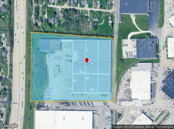
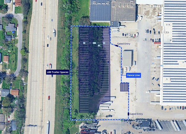
4310 Stout Field Nd Dr, Indianapolis, IN 46241
Current Lease Availabilities
NEARBY LISTINGS FOR SALE OR LEASE
Property Detail
4310 Stout Field Nd Dr
Indianapolis-Carmel-Anderson, IN
G 13.485 ACRES
49-11-18-103-007.000-900
Marion
Warehouse
Indiana
2023
13.49 AC
2024
Airport
342200
Indianapolis
253,928 SF
DEMOGRAPHICS near 4310 Stout Field Nd Dr
1 Mile
3 Mile
5 Mile
2024 Total Population
5,782
57,664
162,474
2029 Population
5,712
57,360
162,315
Pop Growth 2024-2029
(1.21%)
(0.53%)
(0.10%)
Average Age
37
36
36
2024 Total Households
2,136
21,431
63,716
HH Growth 2024-2029
(1.31%)
(0.64%)
(0.10%)
Median Household Inc
$57,999
$56,048
$61,300
Avg Household Size
2.60
2.60
2.40
2024 Avg HH Vehicles
2.00
2.00
2.00
Median Home Value
$77,738
$132,967
$179,999
Median Year Built
1958
1961
1966
Nearby Places
- Restaurants
- Banks
- Shops
- Fitness
- Groceries
PUBLIC TRANSPORTATION
COMMUTER RAIL
Indianapolis (Cardinal - Amtrak)
DRIVE
WALK
Distance
Indianapolis (Cardinal - Amtrak)
11 min
5.7 mi
AIRPORT
Indianapolis International
DRIVE
WALK
Distance
Indianapolis International
19 min
8.6 mi
Freight Ports
Port of Toledo
DRIVE
WALK
Distance
Port of Toledo
280 min
232.2 mi
Nearby Properties
Address
Land Use
TOTAL SIZE
Lot Size
Zoning
Address
Land Use
TOTAL SIZE
Lot Size
Zoning
5,280 SF
97.87 AC
ZO01
Address
Land Use
TOTAL SIZE
Lot Size
Zoning
111,238 SF
0.06 AC
ZO01
Address
Land Use
TOTAL SIZE
Lot Size
Zoning
67,783 SF
44.97 AC
ZO01
Address
Land Use
TOTAL SIZE
Lot Size
Zoning
51,801 SF
0.06 AC
ZO01
Address
Land Use
TOTAL SIZE
Lot Size
Zoning
434,240 SF
26.25 AC
ZO01
Address
Land Use
TOTAL SIZE
Lot Size
Zoning
9,750 SF
43.46 AC
ZO01
Address
Land Use
TOTAL SIZE
Lot Size
Zoning
366,600 SF
29.05 AC
ZO01
Address
Land Use
TOTAL SIZE
Lot Size
Zoning
1,889,477 SF
89.82 AC
ZO01
Address
Land Use
TOTAL SIZE
Lot Size
Zoning
49,008 SF
4.80 AC
ZO01
Address
Land Use
TOTAL SIZE
Lot Size
Zoning
4,663 SF
7.98 AC
ZO01
Address
Land Use
TOTAL SIZE
Lot Size
Zoning
600,000 SF
41.64 AC
ZO01
Address
Land Use
TOTAL SIZE
Lot Size
Zoning
61,832 SF
0.06 AC
ZO01
Address
Land Use
TOTAL SIZE
Lot Size
Zoning
133,706 SF
83.24 AC
ZO01
Address
Land Use
TOTAL SIZE
Lot Size
Zoning
1.88 AC
ZO01
Address
Land Use
TOTAL SIZE
Lot Size
Zoning
28,400 SF
22.04 AC
ZO01
Address
Land Use
TOTAL SIZE
Lot Size
Zoning
101,718 SF
49.77 AC
ZO01
Address
Land Use
TOTAL SIZE
Lot Size
Zoning
2,000 SF
57.60 AC
ZO01
Address
Land Use
TOTAL SIZE
Lot Size
Zoning
5,616 SF
9.34 AC
Address
Land Use
TOTAL SIZE
Lot Size
Zoning
120,734 SF
21.48 AC
Address
Land Use
TOTAL SIZE
Lot Size
Zoning
595,354 SF
193.41 AC
ZO01
Address
Land Use
TOTAL SIZE
Lot Size
Zoning
378,039 SF
0.06 AC
ZO01
Address
Land Use
TOTAL SIZE
Lot Size
Zoning
20,143 SF
17.10 AC
ZO01
Address
Land Use
TOTAL SIZE
Lot Size
Zoning
537,085 SF
111.99 AC
ZO01
Address
Land Use
TOTAL SIZE
Lot Size
Zoning
113,213 SF
0.06 AC
ZO01
Address
Land Use
TOTAL SIZE
Lot Size
Zoning
161,500 SF
9.95 AC
ZO01
Address
Land Use
TOTAL SIZE
Lot Size
Zoning
75,012 SF
0.06 AC
ZO01
Address
Land Use
TOTAL SIZE
Lot Size
Zoning
18,209 SF
38.23 AC
ZO01
Address
Land Use
TOTAL SIZE
Lot Size
Zoning
4,874 SF
21.37 AC
Address
Land Use
TOTAL SIZE
Lot Size
Zoning
6,794 SF
5.37 AC
ZO01
Address
Land Use
TOTAL SIZE
Lot Size
Zoning
13,974 SF
25.90 AC
ZO01
The World's #1 Commercial Real Estate Marketplace
Connect with us
© 2025 CoStar Group
The information above has been obtained from sources believed reliable. While we do not doubt its accuracy we have not verified it and make no guarantee, warranty or representation about it. It is your responsibility to independently confirm its accuracy and completeness. Any projections, opinions, assumptions, or estimates used are for example only and do not represent the current or future performance of the property. The value of this transaction to you depends on tax and other factors which should be evaluated by your tax, financial, and legal advisors. You and your advisors should conduct a careful, independent investigation of the property to determine to your satisfaction the suitability of the property for your needs.