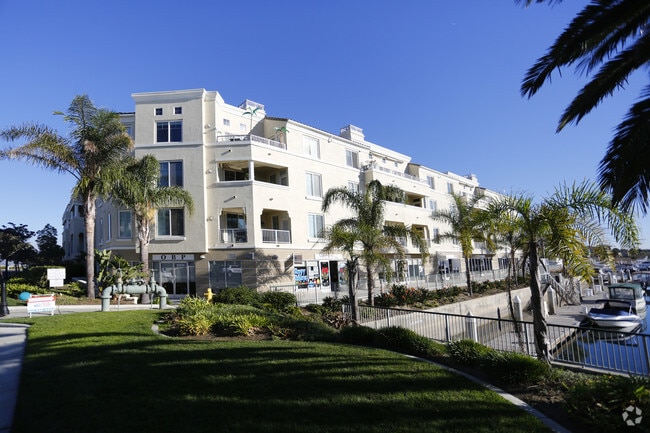
Property Record
4346 Tradewinds Dr, Oxnard, CA 93035
NEARBY LISTINGS FOR SALE OR LEASE
Property Detail
4346 Tradewinds Dr
Oxnard-Thousand Oaks-Ventura, CA
Whitesails
188-0-220-105
Ventura
Condominium
California
X
0.26 AC
06111C0903F
Oxnard/Port Hueneme
2,002 SF
Los Angeles
DEMOGRAPHICS near 4346 Tradewinds Dr
1 Mile
3 Mile
5 Mile
2024 Total Population
14,831
87,776
223,034
2029 Population
15,013
87,152
220,296
Pop Growth 2024-2029
+ 1.23%
(0.71%)
(1.23%)
Average Age
47
39
37
2024 Total Households
6,127
27,212
62,436
HH Growth 2024-2029
+ 1.57%
(0.32%)
(1.03%)
Median Household Inc
$102,772
$86,040
$83,438
Avg Household Size
2.40
3.10
3.40
2024 Avg HH Vehicles
2.00
2.00
2.00
Median Home Value
$815,307
$681,020
$611,826
Median Year Built
1980
1974
1975
Nearby Places
Map Layers
Map Styles
 Street
 Aerial
- Restaurants
- Banks
- Shops
- Fitness
- Groceries
PUBLIC TRANSPORTATION
COMMUTER RAIL
Oxnard (Ventura County Line - Southern California Regional Rail Authority (Metrolink))
DRIVE
WALK
Distance
Oxnard (Ventura County Line - Southern California Regional Rail Authority (Metrolink))
8 min
3.9 mi
DRIVE
WALK
Distance
10 min
5.5 mi
AIRPORT
Santa Barbara Municipal
DRIVE
WALK
Distance
Santa Barbara Municipal
72 min
47.6 mi
Freight Ports
The Port of Hueneme
DRIVE
WALK
Distance
The Port of Hueneme
11 min
5.1 mi
SALE & LEASE HISTORY
LISTING DATE
SALE/LEASE

Jul 27, 2021
For Lease
Jul 20, 2017
For Lease
Feb 03, 2025
For Lease
Nearby Properties
Address
Land Use
TOTAL SIZE
Lot Size
Zoning
Address
Land Use
TOTAL SIZE
Lot Size
Zoning
241,298 SF
8 AC
R3C
Address
Land Use
TOTAL SIZE
Lot Size
Zoning
166,920 SF
7.15 AC
R3PD
Address
Land Use
TOTAL SIZE
Lot Size
Zoning
158,736 SF
6.33 AC
Address
Land Use
TOTAL SIZE
Lot Size
Zoning
129,018 SF
5.09 AC
R3PD
Address
Land Use
TOTAL SIZE
Lot Size
Zoning
Address
Land Use
TOTAL SIZE
Lot Size
Zoning
94,375 SF
7.94 AC
Address
Land Use
TOTAL SIZE
Lot Size
Zoning
70,600 SF
3.75 AC
R3PD
Address
Land Use
TOTAL SIZE
Lot Size
Zoning
98,276 SF
14 AC
R3
Address
Land Use
TOTAL SIZE
Lot Size
Zoning
56,230 SF
1.19 AC
Address
Land Use
TOTAL SIZE
Lot Size
Zoning
71,845 SF
3.01 AC
COPD
Address
Land Use
TOTAL SIZE
Lot Size
Zoning
52,060 SF
4.61 AC
C2PD
Address
Land Use
TOTAL SIZE
Lot Size
Zoning
86,627 SF
6.59 AC
CMPD
Address
Land Use
TOTAL SIZE
Lot Size
Zoning
57,224 SF
3.17 AC
R1
Address
Land Use
TOTAL SIZE
Lot Size
Zoning
1,316 SF
3.86 AC
Address
Land Use
TOTAL SIZE
Lot Size
Zoning
75,685 SF
3.09 AC
Address
Land Use
TOTAL SIZE
Lot Size
Zoning
11,072 SF
12.16 AC
C2PD
Address
Land Use
TOTAL SIZE
Lot Size
Zoning
65,046 SF
2.20 AC
CBD
Address
Land Use
TOTAL SIZE
Lot Size
Zoning
100,612 SF
4.98 AC
R3
Address
Land Use
TOTAL SIZE
Lot Size
Zoning
49,638 SF
1.46 AC
Address
Land Use
TOTAL SIZE
Lot Size
Zoning
31,631 SF
2.45 AC
Address
Land Use
TOTAL SIZE
Lot Size
Zoning
40,179 SF
5.83 AC
Address
Land Use
TOTAL SIZE
Lot Size
Zoning
122,040 SF
7.52 AC
R2PD
Address
Land Use
TOTAL SIZE
Lot Size
Zoning
77,951 SF
2.75 AC
CBD
Address
Land Use
TOTAL SIZE
Lot Size
Zoning
37,500 SF
1.37 AC
Address
Land Use
TOTAL SIZE
Lot Size
Zoning
33,609 SF
2.60 AC
Address
Land Use
TOTAL SIZE
Lot Size
Zoning
40,977 SF
4.14 AC
R1PD
Address
Land Use
TOTAL SIZE
Lot Size
Zoning
32,016 SF
2.28 AC
Address
Land Use
TOTAL SIZE
Lot Size
Zoning
36,894 SF
2.89 AC
Address
Land Use
TOTAL SIZE
Lot Size
Zoning
3.08 AC
Address
Land Use
TOTAL SIZE
Lot Size
Zoning
20,925 SF
2.64 AC
The World's #1 Commercial Real Estate Marketplace
Connect with us
© 2025 CoStar Group
The information above has been obtained from sources believed reliable. While we do not doubt its accuracy we have not verified it and make no guarantee, warranty or representation about it. It is your responsibility to independently confirm its accuracy and completeness. Any projections, opinions, assumptions, or estimates used are for example only and do not represent the current or future performance of the property. The value of this transaction to you depends on tax and other factors which should be evaluated by your tax, financial, and legal advisors. You and your advisors should conduct a careful, independent investigation of the property to determine to your satisfaction the suitability of the property for your needs.