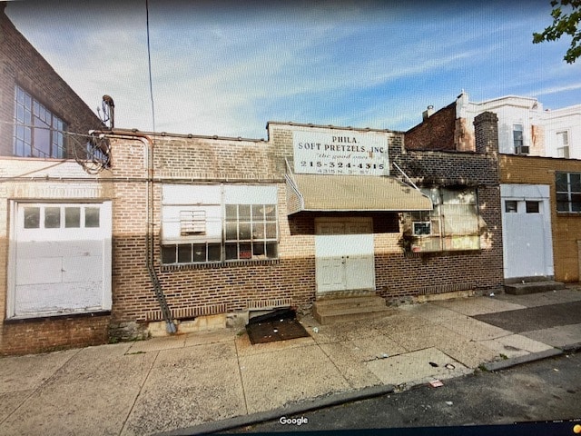
Property Record
4311 N 3Rd St, Philadelphia, PA 19140
Current Lease Availabilities
NEARBY LISTINGS FOR SALE OR LEASE
Property Detail
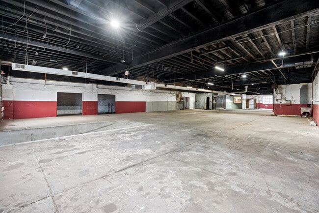
4311 N 3Rd St
884341077
793 N BRISTOL ST
Warehouse
Philadelphia
X
Pennsylvania
42091C0395G
90
2024
0.02 AC
2026
Lower North Philly
019800
Philadelphia
946 SF
Philadelphia-Camden-Wilmington, PA-NJ-DE-MD
DEMOGRAPHICS near 4311 N 3Rd St
1 Mile
3 Mile
5 Mile
2024 Total Population
44,311
445,310
921,676
2029 Population
42,298
432,639
897,313
Pop Growth 2024-2029
(4.54%)
(2.85%)
(2.64%)
Average Age
36
37
38
2024 Total Households
14,938
166,443
371,712
HH Growth 2024-2029
(4.81%)
(2.99%)
(2.72%)
Median Household Inc
$30,463
$37,214
$50,690
Avg Household Size
2.80
2.50
2.30
2024 Avg HH Vehicles
1.00
1.00
1.00
Median Home Value
$83,589
$145,196
$197,626
Median Year Built
1946
1947
1949
Nearby Places
- Restaurants
- Banks
- Shops
- Fitness
- Groceries
PUBLIC TRANSPORTATION
COMMUTER RAIL
Olney (R8 - Southeastern Pennsylvania Transportation Authority Regional Rail (SEPTA Regional Rail))
DRIVE
WALK
Distance
Olney (R8 - Southeastern Pennsylvania Transportation Authority Regional Rail (SEPTA Regional Rail))
5 min
1.5 mi
Wayne Junction (R1 - Southeastern Pennsylvania Transportation Authority Regional Rail (SEPTA Regional Rail), R2 - Southeastern Pennsylvania Transportation Authority Regional Rail (SEPTA Regional Rail), R3 - Southeastern Pennsylvania Transportation Authority Regional Rail (SEPTA Regional Rail), R5 - Southeastern Pennsylvania Transportation Authority Regional Rail (SEPTA Regional Rail), R7 - Southeastern Pennsylvania Transportation Authority Regional Rail (SEPTA Regional Rail), R8 - Southeastern Pennsylvania Transportation Authority Regional Rail (SEPTA Regional Rail))
DRIVE
WALK
Distance
Wayne Junction (R1 - Southeastern Pennsylvania Transportation Authority Regional Rail (SEPTA Regional Rail), R2 - Southeastern Pennsylvania Transportation Authority Regional Rail (SEPTA Regional Rail), R3 - Southeastern Pennsylvania Transportation Authority Regional Rail (SEPTA Regional Rail), R5 - Southeastern Pennsylvania Transportation Authority Regional Rail (SEPTA Regional Rail), R7 - Southeastern Pennsylvania Transportation Authority Regional Rail (SEPTA Regional Rail), R8 - Southeastern Pennsylvania Transportation Authority Regional Rail (SEPTA Regional Rail))
5 min
2.0 mi
AIRPORT
Philadelphia International
DRIVE
WALK
Distance
Philadelphia International
30 min
16.9 mi
Trenton Mercer
DRIVE
WALK
Distance
Trenton Mercer
47 min
30.8 mi
Freight Ports
Port of Philadelphia
DRIVE
WALK
Distance
Port of Philadelphia
10 min
4.6 mi
Nearby Properties
Address
Land Use
TOTAL SIZE
Lot Size
Zoning
Address
Land Use
TOTAL SIZE
Lot Size
Zoning
1.88 AC
SPINS
Address
Land Use
TOTAL SIZE
Lot Size
Zoning
461,286 SF
2.64 AC
CMX4
Address
Land Use
TOTAL SIZE
Lot Size
Zoning
455,889 SF
33 AC
I2
Address
Land Use
TOTAL SIZE
Lot Size
Zoning
285,615 SF
1.46 AC
SPINS
Address
Land Use
TOTAL SIZE
Lot Size
Zoning
96,574 SF
2.42 AC
RM2
Address
Land Use
TOTAL SIZE
Lot Size
Zoning
22,648 SF
38.69 AC
RM3
Address
Land Use
TOTAL SIZE
Lot Size
Zoning
485,616 SF
8.96 AC
CMX3
Address
Land Use
TOTAL SIZE
Lot Size
Zoning
242,655 SF
3.29 AC
CMX3
Address
Land Use
TOTAL SIZE
Lot Size
Zoning
425,535 SF
4.60 AC
RM3
Address
Land Use
TOTAL SIZE
Lot Size
Zoning
3,590 SF
50 AC
SPPOA
Address
Land Use
TOTAL SIZE
Lot Size
Zoning
121,578 SF
3.13 AC
RSA3
Address
Land Use
TOTAL SIZE
Lot Size
Zoning
324,477 SF
1.99 AC
CMX4
Address
Land Use
TOTAL SIZE
Lot Size
Zoning
287,286 SF
1.26 AC
CMX5
Address
Land Use
TOTAL SIZE
Lot Size
Zoning
293,510 SF
7.03 AC
SPINS
Address
Land Use
TOTAL SIZE
Lot Size
Zoning
17,886 SF
80 AC
SPPOA
Address
Land Use
TOTAL SIZE
Lot Size
Zoning
164,412 SF
4.44 AC
SPINS
Address
Land Use
TOTAL SIZE
Lot Size
Zoning
829,504 SF
4.77 AC
SPINS
Address
Land Use
TOTAL SIZE
Lot Size
Zoning
128,164 SF
6.82 AC
SPINS
Address
Land Use
TOTAL SIZE
Lot Size
Zoning
218,960 SF
1.55 AC
RM2
Address
Land Use
TOTAL SIZE
Lot Size
Zoning
425,128 SF
23 AC
RSA5
Address
Land Use
TOTAL SIZE
Lot Size
Zoning
504,972 SF
16.30 AC
RM2
Address
Land Use
TOTAL SIZE
Lot Size
Zoning
425,000 SF
2.08 AC
SPINS
Address
Land Use
TOTAL SIZE
Lot Size
Zoning
500,000 SF
2.30 AC
CMX3
Address
Land Use
TOTAL SIZE
Lot Size
Zoning
218,030 SF
23.75 AC
CA2
Address
Land Use
TOTAL SIZE
Lot Size
Zoning
124,418 SF
2.80 AC
SPINS
Address
Land Use
TOTAL SIZE
Lot Size
Zoning
238,378 SF
18 AC
CA1
Address
Land Use
TOTAL SIZE
Lot Size
Zoning
293,734 SF
4.42 AC
ICMX
Address
Land Use
TOTAL SIZE
Lot Size
Zoning
235,276 SF
1.88 AC
CMX2.5
Address
Land Use
TOTAL SIZE
Lot Size
Zoning
2,500,000 SF
134.14 AC
I2
Address
Land Use
TOTAL SIZE
Lot Size
Zoning
561,600 SF
11.28 AC
CMX3
The World's #1 Commercial Real Estate Marketplace
Connect with us
© 2025 CoStar Group
The information above has been obtained from sources believed reliable. While we do not doubt its accuracy we have not verified it and make no guarantee, warranty or representation about it. It is your responsibility to independently confirm its accuracy and completeness. Any projections, opinions, assumptions, or estimates used are for example only and do not represent the current or future performance of the property. The value of this transaction to you depends on tax and other factors which should be evaluated by your tax, financial, and legal advisors. You and your advisors should conduct a careful, independent investigation of the property to determine to your satisfaction the suitability of the property for your needs.