Property Record
4311 Samuell Blvd, Dallas, TX 75228

NEARBY LISTINGS FOR SALE OR LEASE
-
-
View all Dallas listings for sale on LoopNet.com
Property Detail
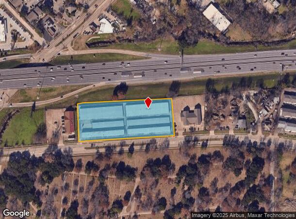
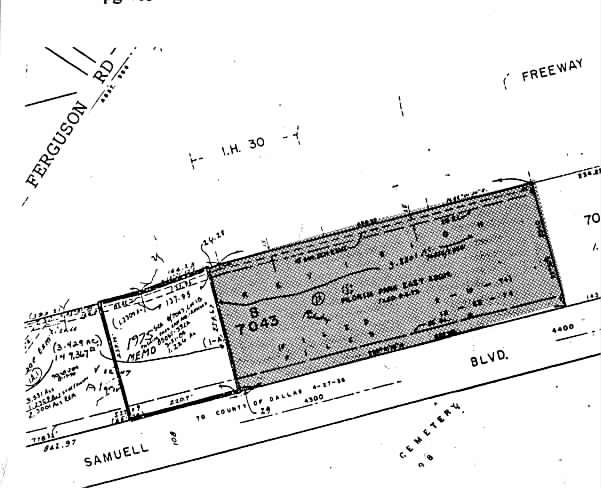
4311 Samuell Blvd
Dallas-Fort Worth-Arlington, TX
Pilgrim Park East
00000664212500000
PILGRIM PARK EAST BLK B/7043 PT LOT 1A ACS 3.820 THORNTON FRWY TO SAMUELL BLVD INT202200083015 DD03222022 CO-DC 7043 00B 01A00 3DA7043 00B
Publicstorage
Dallas
X
Texas
48113C0365K
1a
2024
3.82 AC
2025
Southeast Dallas
008402
Dallas/Ft Worth
94,560 SF
DEMOGRAPHICS near 4311 Samuell Blvd
1 Mile
3 Mile
5 Mile
2024 Total Population
10,930
117,361
378,931
2029 Population
10,820
117,075
378,740
Pop Growth 2024-2029
(1.01%)
(0.24%)
(0.05%)
Average Age
37
37
36
2024 Total Households
4,184
44,672
161,089
HH Growth 2024-2029
(1.22%)
(0.34%)
+ 0.24%
Median Household Inc
$61,858
$56,972
$66,467
Avg Household Size
2.60
2.50
2.30
2024 Avg HH Vehicles
2.00
2.00
2.00
Median Home Value
$289,322
$313,103
$294,011
Median Year Built
1967
1969
1978
Nearby Places
Map Layers
Map Styles
 Street
 Aerial
- Restaurants
- Banks
- Shops
- Fitness
- Groceries
PUBLIC TRANSPORTATION
COMMUTER RAIL
Victory Station (DART LIGHT RAIL - GREEN LINE - Dallas Area Rapid Transit (DART), DART LIGHT RAIL - ORANGE LINE - Dallas Area Rapid Transit (DART), TRINITY RAILWAY - Dallas Area Rapid Transit (DART))
DRIVE
WALK
Distance
Victory Station (DART LIGHT RAIL - GREEN LINE - Dallas Area Rapid Transit (DART), DART LIGHT RAIL - ORANGE LINE - Dallas Area Rapid Transit (DART), TRINITY RAILWAY - Dallas Area Rapid Transit (DART))
11 min
6.7 mi
Medical/Market Ctr Station (TRINITY RAILWAY - Dallas Area Rapid Transit (DART))
DRIVE
WALK
Distance
Medical/Market Ctr Station (TRINITY RAILWAY - Dallas Area Rapid Transit (DART))
15 min
8.6 mi
AIRPORT
Dallas Love Field
DRIVE
WALK
Distance
Dallas Love Field
20 min
10.0 mi
Dallas-Fort Worth International
DRIVE
WALK
Distance
Dallas-Fort Worth International
35 min
26.1 mi
Freight Ports
Port of Shreveport
DRIVE
WALK
Distance
Port of Shreveport
205 min
191.9 mi
Nearby Properties
Address
Land Use
TOTAL SIZE
Lot Size
Zoning
Address
Land Use
TOTAL SIZE
Lot Size
Zoning
372,564 SF
13.34 AC
Z164
Address
Land Use
TOTAL SIZE
Lot Size
Zoning
634,210 SF
73.19 AC
Z298
Address
Land Use
TOTAL SIZE
Lot Size
Zoning
32,530 SF
0.02 AC
Z239
Address
Land Use
TOTAL SIZE
Lot Size
Zoning
392,842 SF
16.79 AC
Z164
Address
Land Use
TOTAL SIZE
Lot Size
Zoning
397,809 SF
18.04 AC
Z298
Address
Land Use
TOTAL SIZE
Lot Size
Zoning
544,700 SF
29.75 AC
Z125
Address
Land Use
TOTAL SIZE
Lot Size
Zoning
239,221 SF
11.01 AC
Z164
Address
Land Use
TOTAL SIZE
Lot Size
Zoning
368,350 SF
1.21 AC
Z59
Address
Land Use
TOTAL SIZE
Lot Size
Zoning
252,473 SF
7.28 AC
Z165
Address
Land Use
TOTAL SIZE
Lot Size
Zoning
245,023 SF
6.84 AC
Z164
Address
Land Use
TOTAL SIZE
Lot Size
Zoning
247,421 SF
3.96 AC
Z133
Address
Land Use
TOTAL SIZE
Lot Size
Zoning
97,000 SF
12.57 AC
Z239
Address
Land Use
TOTAL SIZE
Lot Size
Zoning
509,014 SF
30.82 AC
Z31
Address
Land Use
TOTAL SIZE
Lot Size
Zoning
349,156 SF
10.86 AC
Z59
Address
Land Use
TOTAL SIZE
Lot Size
Zoning
196,386 SF
7.24 AC
Z164
Address
Land Use
TOTAL SIZE
Lot Size
Zoning
244,575 SF
9.91 AC
Z164
Address
Land Use
TOTAL SIZE
Lot Size
Zoning
441,696 SF
30.72 AC
Z31
Address
Land Use
TOTAL SIZE
Lot Size
Zoning
397,800 SF
25.51 AC
Z125
Address
Land Use
TOTAL SIZE
Lot Size
Zoning
174,353 SF
12.64 AC
Z248
Address
Land Use
TOTAL SIZE
Lot Size
Zoning
171,348 SF
5.70 AC
Z164
Address
Land Use
TOTAL SIZE
Lot Size
Zoning
289,172 SF
12.56 AC
Z164
Address
Land Use
TOTAL SIZE
Lot Size
Zoning
110,327 SF
4.12 AC
Z239
Address
Land Use
TOTAL SIZE
Lot Size
Zoning
228,857 SF
21.91 AC
Z298
Address
Land Use
TOTAL SIZE
Lot Size
Zoning
110,708 SF
16.79 AC
Z298
Address
Land Use
TOTAL SIZE
Lot Size
Zoning
196,470 SF
9.64 AC
Z163
Address
Land Use
TOTAL SIZE
Lot Size
Zoning
175,380 SF
6.79 AC
Z164
Address
Land Use
TOTAL SIZE
Lot Size
Zoning
329,692 SF
64.89 AC
Z31
Address
Land Use
TOTAL SIZE
Lot Size
Zoning
89,165 SF
9.60 AC
Z248
Address
Land Use
TOTAL SIZE
Lot Size
Zoning
104,006 SF
4.35 AC
Z164
Address
Land Use
TOTAL SIZE
Lot Size
Zoning
230,304 SF
10.03 AC
Z248
The World's #1 Commercial Real Estate Marketplace
Connect with us
© 2025 CoStar Group
The information above has been obtained from sources believed reliable. While we do not doubt its accuracy we have not verified it and make no guarantee, warranty or representation about it. It is your responsibility to independently confirm its accuracy and completeness. Any projections, opinions, assumptions, or estimates used are for example only and do not represent the current or future performance of the property. The value of this transaction to you depends on tax and other factors which should be evaluated by your tax, financial, and legal advisors. You and your advisors should conduct a careful, independent investigation of the property to determine to your satisfaction the suitability of the property for your needs.